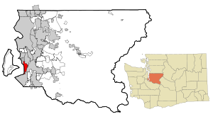
Country:
 USA
USARegion:
City:
Latitude and Longitude:
Time Zone:
Postal Code:
IP information under different IP Channel
ip-api
Country
Region
City
ASN
Time Zone
ISP
Blacklist
Proxy
Latitude
Longitude
Postal
Route
IPinfo
Country
Region
City
ASN
Time Zone
ISP
Blacklist
Proxy
Latitude
Longitude
Postal
Route
MaxMind
Country
Region
City
ASN
Time Zone
ISP
Blacklist
Proxy
Latitude
Longitude
Postal
Route
Luminati
Country
USRegion
wa
City
kent
ASN
Time Zone
America/Los_Angeles
ISP
AS-CHOOPA
Latitude
Longitude
Postal
db-ip
Country
Region
City
ASN
Time Zone
ISP
Blacklist
Proxy
Latitude
Longitude
Postal
Route
ipdata
Country
Region
City
ASN
Time Zone
ISP
Blacklist
Proxy
Latitude
Longitude
Postal
Route
Popular places and events near this IP address
Des Moines, Washington
City in Washington, United States
Distance: Approx. 2693 meters
Latitude and longitude: 47.39416667,-122.31805556
Des Moines ( də-MOYNZ) is a city in King County, Washington, United States. The population was 32,888 as of the 2020 census. The city is located on the east shore of Puget Sound, near the center of the Seattle metropolitan area.

Saltwater State Park
Distance: Approx. 2682 meters
Latitude and longitude: 47.37277778,-122.32333333
Saltwater State Park is a 137 acres (0.55 km2) plot of second-growth timber on Puget Sound in the city of Des Moines, Washington, United States. The main attraction is 1,445 feet (440 m) of saltwater beachfront, including a sandy swimming beach in the southwest corner, and rocky tideflats along the west with a submerged artificial reef that is popular with scuba divers. Overlooked by most visitors is the steep ravine of McSorley (formerly Smith) Creek which winds inland in a gentle "S" curve joined by three tributary streams.

Mount Rainier High School
Public high school in Des Moines, Washington, United States
Distance: Approx. 2662 meters
Latitude and longitude: 47.400125,-122.307916
Mount Rainier High School is a secondary school in Des Moines, Washington, United States; named for Mount Rainier which can be seen quite well from the school on a clear day. Mount Rainier serves approximately 1700 students and has been active since 1957. It was created to handle the overflow from nearby Highline High School, the district's first high school located in Burien, Washington.
Highline College
Community college in Des Moines, Washington, US
Distance: Approx. 1311 meters
Latitude and longitude: 47.38861111,-122.30083333
Highline College is a public community college in Des Moines, Washington. Highline was founded in 1961 as the first community college in King County, Washington. The main campus covers 80 acres (320,000 m2).
Evergreen Lutheran High School
Wisconsin Synod Lutheran high school in Tacoma, Washington
Distance: Approx. 1811 meters
Latitude and longitude: 47.3688,-122.307
Evergreen Lutheran High School (commonly shortened to "Evergreen") is an American private secondary school owned and operated by the Pacific Northwest Lutheran High School Association. It is affiliated with the Wisconsin Evangelical Lutheran Synod and Evangelical Lutheran Synod (WELS and ELS), and is located in Tacoma, Washington. Evergreen Lutheran High School is supported by The Evergreen Lutheran School System (TELSS) which comprises Evangelical Lutheran Synod (ELS) and Wisconsin Evangelical Lutheran Synod (WELS) churches and primary schools in the Puget Sound and Pacific Northwest area.
1965 Puget Sound earthquake
Earthquake in Washington
Distance: Approx. 2389 meters
Latitude and longitude: 47.4,-122.3
The 1965 Puget Sound earthquake occurred at 08:28 AM PDT (15:28 UTC) on April 29 within the Puget Sound region of Washington state. It had a magnitude of 6.7 on the moment magnitude scale and a maximum perceived intensity of VIII (Severe) on the Mercalli intensity scale. It caused the deaths of seven people and about $12.5–28 million in damage.
Cottonwood Grove Park
Distance: Approx. 1650 meters
Latitude and longitude: 47.38805556,-122.27111111
Cottonwood Grove Park is a .77-acre (0.31-hectare) park in the city of Kent, Washington. It is located on the banks of the Green River off Frager Road, at approximately the 23800 block South. In March 1986, remains from a victim of serial killer Gary Ridgway (the Green River Killer) were found in the park.
Kent Des Moines station
Future light rail station in Kent, Washington
Distance: Approx. 1083 meters
Latitude and longitude: 47.3892,-122.293
Kent Des Moines station is a future station on Sound Transit's Federal Way Link Extension, part of the Link light rail system. It is to be located in western Kent, Washington near Highline College. It is scheduled to open in 2026 as part of the extension of the 1 Line to Federal Way Transit Center.
Star Lake station
Future light rail station in Kent, Washington
Distance: Approx. 2418 meters
Latitude and longitude: 47.3588,-122.2975
Star Lake is a future light rail station in southwestern Kent, Washington, United States. It is part of the Link light rail system, operated by Sound Transit, and is being constructed for the Federal Way Link Extension. The station will be located at the existing Star Lake Park and Ride, adjacent to the intersection of Interstate 5 and South 272nd Street.
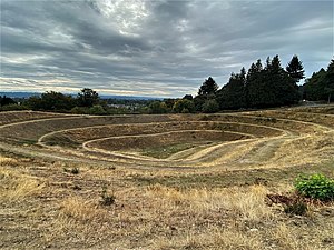
Robert Morris Earthwork
Distance: Approx. 3113 meters
Latitude and longitude: 47.407501,-122.283607
The Robert Morris Earthwork is a 1979 public art earthworks installation in Seatac, Washington by Robert Morris. The area surrounding the piece, a former gravel pit overlooking the Kent Valley outside of Seattle, has been rapidly filled in with urban growth, leading to efforts to both protect it and to enhance public access and enjoyment. The earthwork was the result of a King County government symposium titled Earthworks: Land Reclamation as Sculpture.
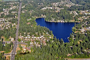
Star Lake (Washington)
Lake in King County, Washington
Distance: Approx. 2776 meters
Latitude and longitude: 47.354909,-122.287071
Star Lake is located in southern King County, Washington in the Lakeland North census-designated place. It is one of two large lakes in Lakeland North, alongside Lake Dolloff. Interstate 5 runs just to the west of the lake.

Lake Fenwick
Lake in Kent, Washington
Distance: Approx. 2073 meters
Latitude and longitude: 47.36583333,-122.27111111
Lake Fenwick is located in King County, Washington, United States, mostly within the city of Kent. The lake is known for its recreational opportunities including fishing and a large public park. The lake has suffered from poor water quality, algae, and infestation by aquatic weeds.
Weather in this IP's area
few clouds
17 Celsius
17 Celsius
16 Celsius
18 Celsius
1015 hPa
73 %
1015 hPa
1000 hPa
10000 meters
4.12 m/s
350 degree
20 %
06:51:24
19:14:53