104.225.213.59 - IP Lookup: Free IP Address Lookup, Postal Code Lookup, IP Location Lookup, IP ASN, Public IP
Country:
 USA
USARegion:
City:
Location:
Time Zone:
Postal Code:
ISP:
ASN:
language:
User-Agent:
Proxy IP:
Blacklist:
IP information under different IP Channel
ip-api
Country
Region
City
ASN
Time Zone
ISP
Blacklist
Proxy
Latitude
Longitude
Postal
Route
db-ip
Country
Region
City
ASN
Time Zone
ISP
Blacklist
Proxy
Latitude
Longitude
Postal
Route
IPinfo
Country
Region
City
ASN
Time Zone
ISP
Blacklist
Proxy
Latitude
Longitude
Postal
Route
IP2Location
104.225.213.59Country
usRegion
missouri
City
saint louis
Time Zone
America/Chicago
ISP
Language
User-Agent
Latitude
Longitude
Postal
ipdata
Country
Region
City
ASN
Time Zone
ISP
Blacklist
Proxy
Latitude
Longitude
Postal
Route
Popular places and events near this IP address

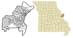
St. Louis County, Missouri
County in Missouri, United States
Distance: Approx. 2719 meters
Latitude and longitude: 38.64,-90.44
St. Louis County is located in eastern Missouri. It is bounded by the City of St.
Country Life Acres, Missouri
Village in Missouri, United States
Distance: Approx. 1322 meters
Latitude and longitude: 38.62472222,-90.45527778
Country Life Acres is a village in St. Louis County, Missouri, United States. The population was 72 at the 2020 census.

Crystal Lake Park, Missouri
City in Missouri, United States
Distance: Approx. 1283 meters
Latitude and longitude: 38.62111111,-90.43194444
Crystal Lake Park is a Missouri Class 4 city in St. Louis County, Missouri, United States. The population was 508 at the 2020 census.

Des Peres, Missouri
City in Missouri, United States
Distance: Approx. 2064 meters
Latitude and longitude: 38.5975,-90.44805556
Des Peres (English: ) is a city in west St. Louis County, Missouri, United States. The population was 8,373 at the 2010 census.
Frontenac, Missouri
City in Missouri, United States
Distance: Approx. 2768 meters
Latitude and longitude: 38.63,-90.41888889
Frontenac is a city in St. Louis County, Missouri, United States. The population was 3,612 at the 2020 census.

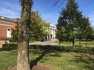
Moog Center for Deaf Education
School in St. Louis, Missouri, USA
Distance: Approx. 2338 meters
Latitude and longitude: 38.63619,-90.45206
The Moog Center for Deaf Education is an American school in St. Louis, Missouri, founded in 1996 by oralist educator Jean Sachar Moog. The Moog Center is an independent, not-for-profit school that provides education services to children with hearing loss and their families from birth to early elementary years.

Visitation Academy of St. Louis
Private, all-girls school in Town and Country, St. Louis, Missouri, United States
Distance: Approx. 2334 meters
Latitude and longitude: 38.63666667,-90.44138889
Visitation Academy of St. Louis is a private, all-girls, Roman Catholic school in Town and Country, Missouri (St. Louis postal address), in the Archdiocese of Saint Louis.

West County Center
Shopping mall in Des Peres, Missouri, St. Louis
Distance: Approx. 1488 meters
Latitude and longitude: 38.60265,-90.4474
West County Center is a shopping mall located in Des Peres, Missouri, a suburb of St. Louis. The original mall was built in 1969.

Temple Emanuel (Creve Coeur, Missouri)
Reform synagogue in Missouri, United States
Distance: Approx. 2846 meters
Latitude and longitude: 38.6414,-90.4474
Temple Emanuel is a Reform Jewish synagogue located at 12166 Conway Road, near the corner of New Ballas Road, in Creve Coeur, Missouri, in the United States. Organized in 1956, it is affiliated with the Union for Reform Judaism (UAHC). It has a membership of 300 families.

Missouri Baptist Medical Center
Hospital in Missouri, United States
Distance: Approx. 2257 meters
Latitude and longitude: 38.63613,-90.44691
Missouri Baptist Medical Center, known locally as MoBap, is a hospital in Town and Country, Missouri. Its origins were in 1884 when Dr. William H. Mayfield opened his home to patients.

Des Peres Presbyterian Church
Historic church in Missouri, United States
Distance: Approx. 2313 meters
Latitude and longitude: 38.62277778,-90.42
Des Peres Presbyterian Church (Old Des Peres Church;Old Stone Church) is a historic church on 2255 Geyer Road in Frontenac, Missouri. It was started in 1834 and was added to the National Register in 1978. Elijah Parish Lovejoy was an early pastor of the church while also serving as an editor of the abolitionist St.
Kirkwood School District
School district in Missouri
Distance: Approx. 2834 meters
Latitude and longitude: 38.600458,-90.4192
The Kirkwood R-7 School District is a public school district headquartered in Kirkwood, Missouri.
Weather in this IP's area
broken clouds
-1 Celsius
-4 Celsius
-1 Celsius
-0 Celsius
1029 hPa
70 %
1029 hPa
1008 hPa
10000 meters
3.09 m/s
330 degree
75 %