Country:
 USA
USARegion:
City:
Latitude and Longitude:
Time Zone:
Postal Code:
IP information under different IP Channel
ip-api
Country
Region
City
ASN
Time Zone
ISP
Blacklist
Proxy
Latitude
Longitude
Postal
Route
IPinfo
Country
Region
City
ASN
Time Zone
ISP
Blacklist
Proxy
Latitude
Longitude
Postal
Route
MaxMind
Country
Region
City
ASN
Time Zone
ISP
Blacklist
Proxy
Latitude
Longitude
Postal
Route
Luminati
Country
USRegion
nc
City
durham
ASN
Time Zone
America/New_York
ISP
NETACTUATE
Latitude
Longitude
Postal
db-ip
Country
Region
City
ASN
Time Zone
ISP
Blacklist
Proxy
Latitude
Longitude
Postal
Route
ipdata
Country
Region
City
ASN
Time Zone
ISP
Blacklist
Proxy
Latitude
Longitude
Postal
Route
Popular places and events near this IP address
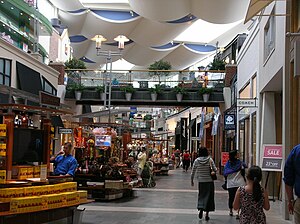
The Streets at Southpoint
Shopping mall
Distance: Approx. 2072 meters
Latitude and longitude: 35.90443333,-78.94183056
The Streets at Southpoint is a shopping mall in Durham, North Carolina. Located near I-40, on Fayetteville Road, the mall was developed by Urban Retail Properties and is currently owned and managed by Brookfield Properties, a subsidiary of Brookfield Asset Management. The Streets at Southpoint opened in 2002.
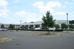
Hillside High School (Durham, North Carolina)
American public school in North Carolina
Distance: Approx. 4617 meters
Latitude and longitude: 35.95305556,-78.90361111
Hillside High School (abbreviated HHS) is a four-year high school located in Durham, North Carolina. Hillside is one of seven high schools in the Durham Public Schools system. Of more than 300 historically black high schools that once operated in the state before desegregation, only five remain today, with Hillside being the oldest.

Charles E. Jordan High School
American public school in North Carolina
Distance: Approx. 3697 meters
Latitude and longitude: 35.9225,-78.9623
Charles E. Jordan High School (generally referred to as Jordan) is located in Durham, North Carolina, United States. It is one of seven high schools in Durham Public Schools. It is located on Garrett Road near Hope Valley Road in southwest Durham.
Mount Zion Christian Academy
American, private, christian school in North Carolina
Distance: Approx. 4834 meters
Latitude and longitude: 35.9559,-78.9063
Mount Zion Christian Academy (MZCA) is a private, college preparatory, non-denominational, co-educational Christian day school (grades K–12) and boarding school (grades 9–12) located in Durham, North Carolina. The Academy is most noted for its successful prep basketball program. The prep program has produced many college players, International players and NBA players.
Hope Valley, Durham, North Carolina
Historic district in North Carolina, United States
Distance: Approx. 4455 meters
Latitude and longitude: 35.94888889,-78.94777778
Hope Valley was the first full-fledged country club community in the suburbs of Durham, Durham County, North Carolina. It is developed around an 18-hole Donald Ross golf course. Created in 1925-26 just before the stock market crash of 1929, Hope Valley remained a unique rural colony until after World War II. Well outside the city limits Hope Valley was situated between Durham and Chapel Hill, and their university campuses, Duke and UNC Chapel Hill.
Blands, North Carolina
Unincorporated community in North Carolina, United States
Distance: Approx. 4298 meters
Latitude and longitude: 35.88805556,-78.95722222
Blands is an unincorporated community in southwestern Durham County, North Carolina, on the intersection of North Carolina Highway 751 and Stagecoach Road, at an elevation of 236 feet (72 m).

Research Triangle High School
American charter school in North Carolina
Distance: Approx. 4855 meters
Latitude and longitude: 35.89506,-78.8743
Research Triangle High School, commonly abbreviated RTHS, is a charter school with a STEM focus located in Research Triangle Park, North Carolina. The school opened in August 2012 with an initial class of 160 freshmen, and now enrolls approximately 590 students in grades 9–12.

Wiley and Elizabeth Forbus House
Historic house in North Carolina, United States
Distance: Approx. 4996 meters
Latitude and longitude: 35.95194444,-78.95305556
Wiley and Elizabeth Forbus House is a historic home located at Durham, Durham County, North Carolina. It was built between 1931 and 1933, and is a two-story, Norman Provincial style brick dwelling. It consists of a central hip-roofed block flanked by side gabled wings.
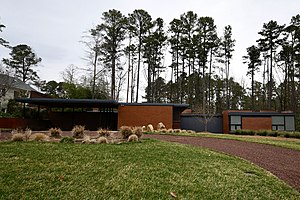
John C. and Binford Carr House
Historic house in North Carolina, United States
Distance: Approx. 4691 meters
Latitude and longitude: 35.94666667,-78.95611111
John C. and Binford Carr House is a historic home located in the Hope Valley Historic District of Durham, North Carolina. It was built in 1958, and is a one-story, T-shaped brick, steel, and glass Modern Movement style dwelling with a flat roof. It originally had 2,337 square feet and employs a Japanese aesthetic with a courtyard plan, a copper door with a simple copper appliqué design, and two sets of Shoji rice paper doors.
Charles DeWitt Watts
American surgeon and activist
Distance: Approx. 5027 meters
Latitude and longitude: 35.959,-78.913
Charles DeWitt Watts (September 21, 1917 – July 12, 2004) was an African-American surgeon and activist for the poor. Watts was the first surgeon of African-American ancestry in North Carolina. Earning his medical degree in 1943 from Howard University College, he was the first African-American board-certified surgeon to serve in North Carolina.

Elion-Hitchings Building
Building in North Carolina, U.S.
Distance: Approx. 4806 meters
Latitude and longitude: 35.911971,-78.869282
The Elion-Hitchings Building on Cornwallis Road in Research Triangle Park, North Carolina, U.S. was an architecturally significant brutalist building designed by Paul Rudolph and completed in 1972 as the headquarters for Burroughs Wellcome. Part of the original building and a later addition were torn down, and despite opposition, the rest of the building was demolished in January 2021.
White Rock Baptist Church
Historic African American Church that played an important role in the Civil Rights movement.
Distance: Approx. 4901 meters
Latitude and longitude: 35.9575,-78.91083333
White Rock Baptist Church is a historically African American church that was founded in Durham, North Carolina, in 1866. The congregation first met in the home of Margaret Ruffin Faucette in Durham's Hayti neighborhood. The Reverends Zuck Horton and Samuel Daddy Hunt were the first ministers to lead the congregation.
Weather in this IP's area
heavy intensity rain
19 Celsius
19 Celsius
18 Celsius
20 Celsius
1015 hPa
97 %
1015 hPa
1002 hPa
3219 meters
6.69 m/s
12.35 m/s
30 degree
100 %
06:59:25
19:21:30