104.218.68.237 - IP Lookup: Free IP Address Lookup, Postal Code Lookup, IP Location Lookup, IP ASN, Public IP
Country:
 USA
USARegion:
City:
Location:
Time Zone:
Postal Code:
ISP:
ASN:
language:
User-Agent:
Proxy IP:
Blacklist:
IP information under different IP Channel
ip-api
Country
Region
City
ASN
Time Zone
ISP
Blacklist
Proxy
Latitude
Longitude
Postal
Route
db-ip
Country
Region
City
ASN
Time Zone
ISP
Blacklist
Proxy
Latitude
Longitude
Postal
Route
IPinfo
Country
Region
City
ASN
Time Zone
ISP
Blacklist
Proxy
Latitude
Longitude
Postal
Route
IP2Location
104.218.68.237Country
usRegion
nebraska
City
bayard
Time Zone
America/Denver
ISP
Language
User-Agent
Latitude
Longitude
Postal
ipdata
Country
Region
City
ASN
Time Zone
ISP
Blacklist
Proxy
Latitude
Longitude
Postal
Route
Popular places and events near this IP address

Bayard, Nebraska
City in Nebraska, United States
Distance: Approx. 262 meters
Latitude and longitude: 41.75722222,-103.32305556
Bayard is a city in Morrill County, Nebraska, United States. The population was 1,140 at the 2020 census.
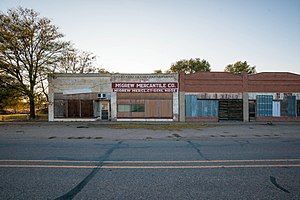
McGrew, Nebraska
Village in Scotts Bluff County, Nebraska, United States
Distance: Approx. 7775 meters
Latitude and longitude: 41.74777778,-103.41722222
McGrew is a village in Scotts Bluff County, Nebraska, United States. It is part of the Scottsbluff, Nebraska Micropolitan Statistical Area. The population was 105 at the 2010 census.
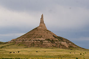
Chimney Rock National Historic Site
Historic site in Nebraska, United States
Distance: Approx. 6065 meters
Latitude and longitude: 41.70361111,-103.34833333
Chimney Rock is a prominent geological rock formation in Morrill County in western Nebraska. Rising nearly 300 feet (91 m) above the surrounding North Platte River valley, the peak of Chimney Rock is 4,228 feet (1,289 m) above sea level. The formation served as a landmark along the Oregon Trail, the California Trail, and the Mormon Trail during the mid-19th century.

Atkins, Nebraska
Unincorporated community in Nebraska, United States
Distance: Approx. 9680 meters
Latitude and longitude: 41.72388889,-103.21527778
Atkins is an unincorporated community in Morrill County, Nebraska, United States.
Bradley, Nebraska
Unincorporated Community in Nebraska, United States
Distance: Approx. 5117 meters
Latitude and longitude: 41.77027778,-103.38222222
Bradley is an unincorporated community in Scotts Bluff County, Nebraska, in the United States.
Weather in this IP's area
overcast clouds
6 Celsius
1 Celsius
6 Celsius
6 Celsius
998 hPa
26 %
998 hPa
868 hPa
10000 meters
10.79 m/s
19.1 m/s
268 degree
86 %