Country:
Region:
City:
Latitude and Longitude:
Time Zone:
Postal Code:
IP information under different IP Channel
ip-api
Country
Region
City
ASN
Time Zone
ISP
Blacklist
Proxy
Latitude
Longitude
Postal
Route
Luminati
Country
Region
ny
City
newyork
ASN
Time Zone
America/New_York
ISP
CROWNCASTLE-AS46887
Latitude
Longitude
Postal
IPinfo
Country
Region
City
ASN
Time Zone
ISP
Blacklist
Proxy
Latitude
Longitude
Postal
Route
db-ip
Country
Region
City
ASN
Time Zone
ISP
Blacklist
Proxy
Latitude
Longitude
Postal
Route
ipdata
Country
Region
City
ASN
Time Zone
ISP
Blacklist
Proxy
Latitude
Longitude
Postal
Route
Popular places and events near this IP address

North River (Hudson River)
Section of the Hudson River between New York City and New Jersey
Distance: Approx. 591 meters
Latitude and longitude: 40.78666667,-73.99194444
North River (Dutch: Noort Rivier) is an alternative name for the southernmost portion of the Hudson River in the vicinity of New York City and northeastern New Jersey in the United States.

Riverside South, Manhattan
Building complex in New York City
Distance: Approx. 693 meters
Latitude and longitude: 40.778,-73.989
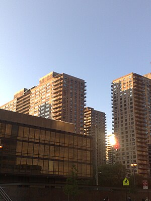
Riverside South is an urban development project in the Lincoln Square neighborhood of the Upper West Side of Manhattan, New York City, United States. Developed by the businessman Donald Trump in collaboration with six civic associations, the largely residential complex is on 57 acres (23 ha) of land along the Hudson River between 59th Street and 72nd Street. The $3 billion project, which replaced a New York Central Railroad yard known as the 60th Street Yard, includes multiple residential towers and a extension of Riverside Park.

New York Central Railroad 69th Street Transfer Bridge
Historic dock in Manhattan, New York
Distance: Approx. 570 meters
Latitude and longitude: 40.779209,-73.989626
The 69th Street Transfer Bridge, part of the West Side Line of the New York Central Railroad, was a dock for car floats which allowed the transfer of railroad cars from the rail line to car floats which crossed the Hudson River to the Weehawken Yards in New Jersey. Its innovative linkspan design kept the boxcars from falling into the river while being loaded. After it fell into disuse, it was in danger of being torn down and removed, but around the year 2000, during renovations of Riverside Park, following the example of Gantry Plaza State Park, it became a prominent feature of the park.

Lincoln Towers
Apartment complex in Manhattan, New York
Distance: Approx. 894 meters
Latitude and longitude: 40.777,-73.987
Lincoln Towers is an apartment complex on the Upper West Side of the New York City borough of Manhattan that consists of six buildings with eight addresses on a 20-acre (81,000 m2) campus.

Septuagesimo Uno
Public park in Manhattan, New York
Distance: Approx. 998 meters
Latitude and longitude: 40.77866667,-73.98430556
Septuagesimo Uno is a 0.04-acre (160 m2) park in the Upper West Side of the New York City borough of Manhattan. It is located on 71st Street between West End Avenue to the west and the intersection of Broadway and Amsterdam Avenue to the east. The park's name is Latin for "seventy-first".
79th Street Boat Basin
Marina in Manhattan, New York
Distance: Approx. 961 meters
Latitude and longitude: 40.78611111,-73.98527778
The 79th Street Boat Basin is a marina located in the Hudson River on the Upper West Side of Manhattan in New York City, within Riverside Park at the western end of 79th Street. Maintained and operated by the New York City Department of Parks and Recreation, it is the only facility in the city that allows year-round residency in boats, so it is a hub for houseboats in New York City. The marina closed for rebuilding in 2021 and was still closed as of July 2024.

Manhattan Day School
Distance: Approx. 938 meters
Latitude and longitude: 40.78202778,-73.98416944
Manhattan Day School, often referred to as MDS, is a co-educational Modern Orthodox Jewish yeshiva elementary school located on the Upper West Side of Manhattan. It was founded in 1943 as Yeshivat Ohr Torah Community School, the first Jewish all-day independent school on the West Side of Manhattan. The rabbis and congregants of Congregation Ohab Zedek and The Jewish Center helped Dr.

Charles M. Schwab House
Demolished mansion in Manhattan, New York
Distance: Approx. 916 meters
Latitude and longitude: 40.7811,-73.9845
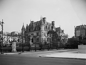
The Charles M. Schwab House (also called Riverside) was a 75-room mansion on Riverside Drive, between 73rd and 74th Streets, on the Upper West Side of Manhattan in New York City. It was constructed for steel magnate Charles M. Schwab. The home was considered to be the classic example of a "white elephant", as it was built on the "wrong" side of Central Park away from the more fashionable Upper East Side.
The Level Club
United States historic place
Distance: Approx. 1027 meters
Latitude and longitude: 40.78027778,-73.98333333
The Level Club is a residential building at 253 West 73rd Street on the Upper West Side of Manhattan in New York City. It was built as a men's club by a group of Freemasons in 1927; it served this original function for just about three years. Afterwards, the building was used, in turn, as a hotel and a drug re-hab center.

Battle of Bull's Ferry
1780 battle of the American Revolutionary War
Distance: Approx. 874 meters
Latitude and longitude: 40.789,-74
The Battle of Bull's Ferry on 20 and 21 July 1780 saw two American brigades under Brigadier-General Anthony Wayne attack a party of Loyalists led by Thomas Ward. The Loyalists successfully defended a blockhouse against an ineffective bombardment by four American artillery pieces and a failed attempt to storm the position by Wayne's troops. During the action, American light dragoons under Major Henry Lee III drove off a large number of cattle that were kept in the area for the use of the British forces stationed in New York City.

Eleanor Roosevelt Monument
Sculpture in Manhattan, New York, U.S.
Distance: Approx. 816 meters
Latitude and longitude: 40.78065,-73.98579
The Eleanor Roosevelt Monument is located at the southeast corner of New York City's Riverside Park. It was the first work of public art in New York City to be dedicated to an American woman and, according to the Eleanor Roosevelt Monument Fund, which provided much of the funding for the project, it was the first work of public art to be dedicated to an American president's wife. The centerpiece of the monument is a bronze statue of Eleanor Roosevelt.

One Riverside Park
Residential skyscraper in Manhattan, New York
Distance: Approx. 938 meters
Latitude and longitude: 40.774117,-73.991373
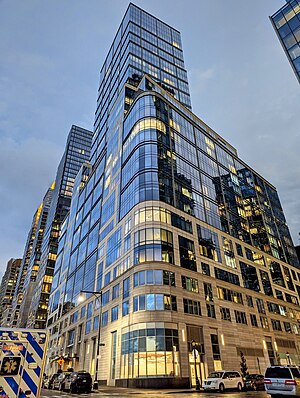
One Riverside Park is a skyscraper at 40 Riverside Boulevard in Riverside South, on the Upper West Side neighborhood of Manhattan, New York City. Its name was later changed to 50 Riverside Boulevard following media reports related to the development's "poor door". The building consists of 33 floors containing 219 residential units.
Weather in this IP's area
clear sky
17 Celsius
16 Celsius
16 Celsius
18 Celsius
1010 hPa
50 %
1010 hPa
1010 hPa
10000 meters
8.23 m/s
300 degree
06:47:11
16:35:39

