Country:
 Canada
Region:
City:
Latitude and Longitude:
Time Zone:
Postal Code:
IP information under different IP Channel
ip-api
Country
Region
City
ASN
Time Zone
ISP
Blacklist
Proxy
Latitude
Longitude
Postal
Route
IPinfo
Country
Region
City
ASN
Time Zone
ISP
Blacklist
Proxy
Latitude
Longitude
Postal
Route
MaxMind
Country
Region
City
ASN
Time Zone
ISP
Blacklist
Proxy
Latitude
Longitude
Postal
Route
Luminati
Country
CARegion
qc
City
leseboulements
ASN
Time Zone
America/Toronto
ISP
CC-3272
Latitude
Longitude
Postal
db-ip
Country
Region
City
ASN
Time Zone
ISP
Blacklist
Proxy
Latitude
Longitude
Postal
Route
ipdata
Country
Region
City
ASN
Time Zone
ISP
Blacklist
Proxy
Latitude
Longitude
Postal
Route
Popular places and events near this IP address
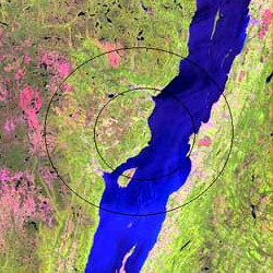
Charlevoix impact structure
Asteroid impact site in Quebec, Canada
Distance: Approx. 5777 meters
Latitude and longitude: 47.53333333,-70.3
The Charlevoix impact structure is a large eroded meteorite impact structure in the Charlevoix region of Quebec, Canada. Only part of the impact structure is exposed at the surface, the rest lying beneath the Saint Lawrence River.
1997 Les Éboulements bus accident
Disaster in Quebec, Canada in 1997
Distance: Approx. 2600 meters
Latitude and longitude: 47.46311389,-70.33946944
The 1997 Les Éboulements bus accident, also known as the St. Joseph Bus Accident, occurred on Thanksgiving Day, October 13, 1997, in Les Éboulements (St-Joseph-de-la-Rive), Quebec, Canada. 44 died as a result of the crash, making it the deadliest traffic collision in Canadian history.
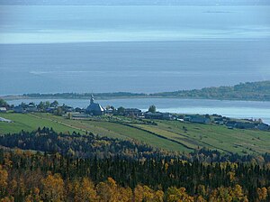
Les Éboulements
Municipality in Quebec, Canada
Distance: Approx. 581 meters
Latitude and longitude: 47.48333333,-70.31666667
Les Éboulements is a municipality in the Capitale-Nationale region of Quebec, Canada. Its population centres include Les Éboulements (located along Route 362 on the plateau overlooking the Saint Lawrence River), Éboulements-Est (at the feet of Mount Éboulements), Cap-aux-Oies, Sainte-Marie-de-Charlevoix, and Saint-Joseph-de-la-Rive (47°27′30″N 70°22′05″W on the shores of the Saint Lawrence facing Saint-Bernard-sur-Mer). Saint-Joseph-de-la-Rive, formerly known as Les Éboulements-en-Bas and Quai-des-Éboulements, is the departure point for ferries to L'Isle-aux-Coudres.
Rivière du Premier Rang
River in Charlevoix Regional County Municipality, Quebec, Canada
Distance: Approx. 8281 meters
Latitude and longitude: 47.55778,-70.33945
The Rivière du Premier Rang (English: First Row River) is a tributary of the west bank of the Jean-Noël River flowing on the north bank of the Saint Lawrence River, in the municipalities of Saint-Hilarion and Les Éboulements, in the MRC of Charlevoix Regional County Municipality, in the administrative region of Capitale-Nationale, in the province of Quebec, in Canada. The southern part of this small valley is accessible by the chemin du 1er Rang de Saint-Hilarion and the chemin du rang Saint-Nicolas (south side of the river) of Les Éboulements. The upper part is served by Chemin Principal de Saint-Hilarion and chemin des Pins.
Armand-Jude River
River in Charlevoix Regional County Municipality, Quebec, Canada
Distance: Approx. 5628 meters
Latitude and longitude: 47.52278,-70.3725
The Armand-Jude River is a tributary of the north bank of the rivière du Seigneur on the northwest bank of the Saint Lawrence river. This stream flows in the municipality of Les Éboulements, in the Charlevoix Regional County Municipality, in the administrative region of Capitale-Nationale, in the province of Quebec, in Canada. The valley of this stream is mainly served by the path of Saint-Hilarion which goes north to the east side.
Rivière du Seigneur
River in Charlevoix Regional County Municipality, Quebec, Canada
Distance: Approx. 2642 meters
Latitude and longitude: 47.46278,-70.33972
The rivière du Seigneur (English: River of the Lord) is a tributary of the northwest shore of the St. Lawrence River, in the municipality of Les Éboulements, in the Charlevoix Regional County Municipality, in the administrative region of Capitale-Nationale, in the province of Quebec, in Canada. The upper part of this small valley is accessible by the chemin du rang Sainte-Marie and by the chemin du rang Sainte-Catherine.
Rivière des Boudreault
River in Charlevoix Regional County Municipality, Quebec, Canada
Distance: Approx. 4222 meters
Latitude and longitude: 47.45667,-70.36305
The Rivière des Boudreault (English: Boudreault's River) is a tributary of the northwest shore of the St. Lawrence River, in the municipality of Les Éboulements, in the Charlevoix Regional County Municipality, in the administrative region of Capitale-Nationale, in the province of Quebec, in Canada. The upper part of this small valley is accessible by the chemin du rang Sainte-Marie (east–west direction).

Charlevoix Biosphere Reserve
UNESCO Biosphere Reserve in Quebec, Canada
Distance: Approx. 5777 meters
Latitude and longitude: 47.53333333,-70.3
The Charlevoix Biosphere Reserve is part of the Man and the Biosphere Program of the UNESCO. It is managed by the Charlevoix Biosphere Reserve Corporation. In Canada, the Canadian Commission for UNESCO deals with reservations. In addition, there is also the Canadian Association of Biosphere Reservesé Canada currently has 19 biosphere reserves.
Weather in this IP's area
clear sky
12 Celsius
11 Celsius
10 Celsius
12 Celsius
1029 hPa
81 %
1029 hPa
997 hPa
10000 meters
2.77 m/s
3.6 m/s
246 degree
2 %
07:04:44
17:47:38