Country:
 Belgium
Region:
City:
Latitude and Longitude:
Time Zone:
Postal Code:
IP information under different IP Channel
ip-api
Country
Region
City
ASN
Time Zone
ISP
Blacklist
Proxy
Latitude
Longitude
Postal
Route
IPinfo
Country
Region
City
ASN
Time Zone
ISP
Blacklist
Proxy
Latitude
Longitude
Postal
Route
MaxMind
Country
Region
City
ASN
Time Zone
ISP
Blacklist
Proxy
Latitude
Longitude
Postal
Route
Luminati
Country
BERegion
bru
City
brussels
ASN
Time Zone
Europe/Brussels
ISP
GOOGLE-CLOUD-PLATFORM
Latitude
Longitude
Postal
db-ip
Country
Region
City
ASN
Time Zone
ISP
Blacklist
Proxy
Latitude
Longitude
Postal
Route
ipdata
Country
Region
City
ASN
Time Zone
ISP
Blacklist
Proxy
Latitude
Longitude
Postal
Route
Popular places and events near this IP address

Steenokkerzeel
Municipality in Flemish Community, Belgium
Distance: Approx. 2805 meters
Latitude and longitude: 50.91666667,4.51666667
Steenokkerzeel (Dutch pronunciation: [ˌsteːnˈɔkərzeːl]) is a municipality located in the Belgian province of Flemish Brabant. The municipality comprises the towns of Melsbroek, Perk and Steenokkerzeel proper. On December 31, 2010 Steenokkerzeel had a total population of 11,580.

Kortenberg
Municipality in Flemish Community, Belgium
Distance: Approx. 3887 meters
Latitude and longitude: 50.88333333,4.53333333
Kortenberg (Dutch pronunciation: [ˈkɔrtə(m)bɛr(ə)x]; French: Cortenbergh) is a Belgian municipality located in the province of Flemish Brabant, about halfway between the cities of Brussels and Leuven. The municipality comprises the subdivisions or deelgemeenten of Erps-Kwerps, Everberg, Kortenberg proper and Meerbeek. On 1 January 2013 Kortenberg had a total population of 19,393.

Brussels Airport
International airport serving Brussels, Belgium
Distance: Approx. 92 meters
Latitude and longitude: 50.90138889,4.48444444
Brussels Airport (Dutch: Luchthaven Brussel, French: Aéroport de Bruxelles) (IATA: BRU, ICAO: EBBR) — also informally called Brussels-National Airport (Luchthaven Brussel-Nationaal, Aéroport de Bruxelles-National) or Brussels-Zaventem Airport (Luchthaven Brussel-Zaventem, Aéroport de Bruxelles-Zaventem) — is an international airport in the municipality of Zaventem in Flemish Brabant, 6.5 nautical miles (12.0 km; 7.5 mi) northeast of Brussels, Belgium. In 2019, more than 26 million passengers arrived or departed at Brussels Airport, making it the 26th busiest airport in Europe. It is home to around 260 companies, together directly employing 20,000 people and serves as the home base for Brussels Airlines and TUI fly Belgium.
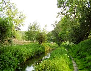
Woluwe
Stream in Brussels, Belgium
Distance: Approx. 3168 meters
Latitude and longitude: 50.88333333,4.45
The Woluwe (Dutch pronunciation: [ˈʋoːlyʋə]; French pronunciation: [wɔlywe]) is a stream that goes through several municipalities in the south-east and east of Brussels, Belgium, and is a right tributary of the Senne in Vilvoorde. The Kleine (little) Maalbeek is a tributary of the Woluwe in Kraainem. Many ponds formed along the stream over time, among which the Mellaerts Ponds still exist.

Sabena Flight 548
1961 fatal crash of a Boeing 707 in Belgium
Distance: Approx. 3655 meters
Latitude and longitude: 50.9209,4.5268
Sabena Flight 548 was a Boeing 707-329 flight operated by Sabena that crashed en route from New York City to Brussels, Belgium on 15 February 1961. The flight, which had originated at Idlewild International Airport, crashed on approach to Brussels Airport, killing all 72 people on board and one person on the ground. The fatalities included the entire United States figure skating team, which was traveling to the World Figure Skating Championships in Prague, Czechoslovakia.

Diegem
Distance: Approx. 3580 meters
Latitude and longitude: 50.894232,4.435623
Diegem is a town in the municipality of Machelen, in the province of Flemish Brabant, Belgium. Diegem's postal code is 1831. The official language of Diegem is Dutch, as in the rest of Flanders.
Melsbroek Air Base
Airport in Steenokkerzeel
Distance: Approx. 92 meters
Latitude and longitude: 50.90138889,4.48444444
Melsbroek Air Base (ICAO: EBMB) is a Belgian Air Component facility in Steenokkerzeel, 6.5 NM (12.0 km; 7.5 mi) northeast of Brussels, the capital of Belgium. It is located on the northern side of Brussels Airport, with which it shares runways and ground and air control facilities.
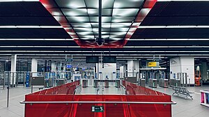
Brussels Airport-Zaventem railway station
Railway station in Flemish Brabant, Belgium
Distance: Approx. 413 meters
Latitude and longitude: 50.89722222,4.48472222
Brussels Airport-Zaventem railway station (Dutch: Station Brussels Airport-Zaventem; French: Gare de Brussels Airport-Zaventem) is a railway station located beneath Brussels Airport in Zaventem, Flemish Brabant, Belgium. The station opened in 1958 on railway line 36C; in 2012, the new line 25N was added. It was formerly called Brussels-National-Airport railway station (Dutch: Station Brussel-Nationaal-Luchthaven; French: Gare de Bruxelles-National-Aéroport) until April 2016.

Nossegem
Distance: Approx. 2205 meters
Latitude and longitude: 50.88333333,4.5
Nossegem is a town located near Brussels, the capital of Belgium. It is part of Zaventem municipality, in the Flemish Brabant province. In 2005, the Nossegem Curve was opened, which connects Brussels Airport with the railway in the direction of Leuven.
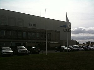
Sabena Flight Academy
Distance: Approx. 1354 meters
Latitude and longitude: 50.90270833,4.50456667
CAE Oxford Aviation Academy Brussels - Sabena Flight Academy is an aviation training organisation created in 1953, and located in Steenokkerzeel (Belgium). The school is now part of CAE Global Academy. The training is performed in Brussels, in Mesa at CAE Oxford Aviation Academy Phoenix (formerly Sabena Airline Training Center).

Brussels Airport diamond heist
2013 diamond heist
Distance: Approx. 92 meters
Latitude and longitude: 50.90138889,4.48444444
On 18 February 2013, eight masked gunmen in two cars with police markings stole approximately €38,000,000 (US$50,000,000, £33,000,000) worth of diamonds from a Swiss-bound Fokker 100 operated by Helvetic Airways on the apron at Brussels Airport, Belgium, just before 20:00 CET. The heist was accomplished without a single shot being fired.

Vilvoorde railway station
Railway station in Flemish Brabant, Belgium
Distance: Approx. 2776 meters
Latitude and longitude: 50.92416667,4.49972222
Vilvoorde railway station (Dutch: Station Vilvoorde; French: Gare de Vilvorde) is a railway station in Vilvoorde, Flemish Brabant, Belgium. The station opened on 5 May 1835 on the country's first railway, from Brussels to Mechelen; later to become railway lines 25 and 27. The train services are operated by the National Railway Company of Belgium (NMBS/SNCB).
Weather in this IP's area
clear sky
14 Celsius
14 Celsius
14 Celsius
15 Celsius
1027 hPa
82 %
1027 hPa
1022 hPa
10000 meters
3.6 m/s
360 degree
07:19:25
19:54:25