Country:
Region:
City:
Latitude and Longitude:
Time Zone:
Postal Code:
IP information under different IP Channel
ip-api
Country
Region
City
ASN
Time Zone
ISP
Blacklist
Proxy
Latitude
Longitude
Postal
Route
Luminati
Country
Region
or
City
thedalles
ASN
Time Zone
America/Los_Angeles
ISP
GOOGLE-CLOUD-PLATFORM
Latitude
Longitude
Postal
IPinfo
Country
Region
City
ASN
Time Zone
ISP
Blacklist
Proxy
Latitude
Longitude
Postal
Route
db-ip
Country
Region
City
ASN
Time Zone
ISP
Blacklist
Proxy
Latitude
Longitude
Postal
Route
ipdata
Country
Region
City
ASN
Time Zone
ISP
Blacklist
Proxy
Latitude
Longitude
Postal
Route
Popular places and events near this IP address

The Dalles Carnegie Library
United States historic place
Distance: Approx. 725 meters
Latitude and longitude: 45.599983,-121.183617
The Dalles Carnegie Library is a historic former library building located in The Dalles, Oregon, United States. It is one of the thousands of libraries whose construction was funded by Andrew Carnegie. The construction grant of $10,000 was approved in March 1907, and it was dedicated in September 1910.
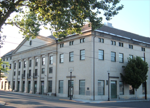
The Dalles Civic Auditorium
United States historic place
Distance: Approx. 649 meters
Latitude and longitude: 45.599796,-121.182098
The Dalles Civic Auditorium is a historic building on the National Register of Historic Places located at the corner of Fourth and Federal streets in The Dalles, Oregon. It is currently owned by the Civic Auditorium Historic Preservation Committee, a non-profit corporation formed specifically for the purpose of purchasing it from the City of The Dalles to save it from scheduled demolition, restore it, and operate it as a local and regional cultural center. "The Civic," as it is most commonly called, was once an important center of cultural and recreational activity for its community and region, and after more than a decade of dereliction and disuse, has been partially restored with plans in place for complete rehabilitation.

Fort Dalles
US Army outpost
Distance: Approx. 725 meters
Latitude and longitude: 45.5997222,-121.1841667
Fort Dalles was a United States Army outpost located on the Columbia River at the present location of The Dalles, Oregon, in the United States. Built when Oregon was a territory, the post was used mainly for dealing with wars with Native Americans. The post was first known as Camp Drum and then Fort Drum.
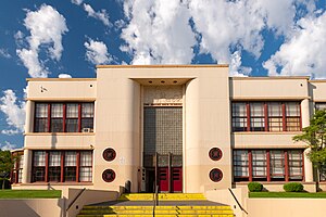
The Dalles High School
School in Oregon, United States
Distance: Approx. 716 meters
Latitude and longitude: 45.5958,-121.1876
The Dalles High School (TDHS), formerly The Dalles Wahtonka High School (TDW) is a public high school located in The Dalles, Oregon, United States. It houses students from both The Dalles and the adjacent town of Mosier.

Edward F. Sharp Residential Ensemble
Historic house in Oregon, United States
Distance: Approx. 573 meters
Latitude and longitude: 45.599113,-121.18185
The Edward F. Sharp Residential Ensemble, also known as the Sharp Family Residential Ensemble, is a set of three adjacent historic houses in The Dalles, Oregon, United States. Edward Sharp (1865–1954) was the county surveyor and roadmaster whose work underlies much of the development in The Dalles and Wasco County. As the official surveyor for the Eastern Oregon Land Company, he also conducted important early surveys across large stretches of Oregon and Idaho.
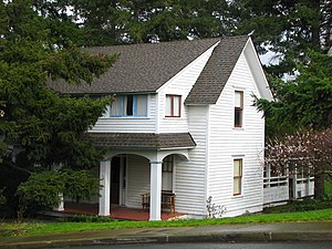
Fulton–Taylor House
Historic house in Oregon, United States
Distance: Approx. 565 meters
Latitude and longitude: 45.597913,-121.183966
The Fulton–Taylor House is a historic house located in The Dalles, Oregon, United States. Built and modified in phases between circa 1858 and circa 1930, this house is only one of a few remaining houses of similar age and style in The Dalles. James Fulton (in residence 1864 – 1881) emigrated to Oregon on the Oregon Trail, and eventually established himself as a cattle rancher, leader of the settler militia, and a state legislator.

Heimrich–Seufert House
Historic house in Oregon, United States
Distance: Approx. 635 meters
Latitude and longitude: 45.596722,-121.18611
The Heimrich–Seufert House (also known as the John G. Heimrich House or Edward Seufert House) is a historic house in The Dalles, Oregon, United States.
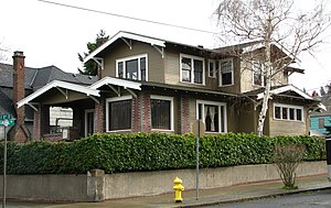
John and Murta Van Dellen House
Historic house in Oregon, United States
Distance: Approx. 499 meters
Latitude and longitude: 45.597112,-121.18381
The John and Murta Van Dellen House is a historic house located in The Dalles, Oregon, United States. Built in 1920, it is the outstanding example of a California bungalow in The Dalles. Original owner John Van Dellen was a prosperous lumber yard owner, and made use of the finest local building materials and craftsmanship in constructing his house.
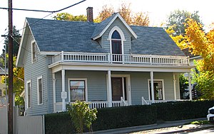
Orlando Humason House
Historic house in Oregon, United States
Distance: Approx. 736 meters
Latitude and longitude: 45.597573,-121.18696
The Orlando Humason House is a historic house located in The Dalles, Oregon, United States. Humason (1828–1875), the "Father of Wasco County", lived in this modest Gothic Revival house from its construction in 1860 until his death. Originally from Ohio, he worked in law, prospecting, agriculture, and journalism, prior to settling in The Dalles as a prosperous merchant and river transport businessman.

The Dalles Mint
Building in Oregon, US
Distance: Approx. 462 meters
Latitude and longitude: 45.598431,-121.176716
The Dalles Mint was to be a branch of the United States Mint in The Dalles in Oregon. Partially constructed in 1869, the planned two-story structure was never completed and the mint was never put into operation. Located in the downtown area of the city, the building was given to the state before it was sold to the public.
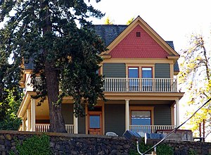
Joseph D. and Margaret Kelly House
Historic house in Oregon, United States
Distance: Approx. 328 meters
Latitude and longitude: 45.597436,-121.178181
The Joseph D. and Margaret Kelly House is a historic residence in The Dalles, Oregon, United States. Joseph Kelly, a highly successful farmer during the establishment of wheat as a major cash crop in Wasco County, retired young to this 1908 blufftop house and continued his career as a landlord and businessman. He and his wife Margaret, a teacher and member of another important wheat family, became a prominent philanthropic figures in The Dalles.
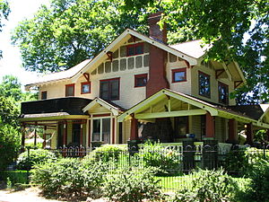
Dr. J. A. Reuter House
Historic house in Oregon, United States
Distance: Approx. 430 meters
Latitude and longitude: 45.596845,-121.182984
The Dr. J. A. Reuter House is a historic house in The Dalles, Oregon, United States. John Alexander Reuter (1876–1954) practiced medicine in The Dalles for 44 years (1902–1946), joining a partnership that established the city's first hospital (1901) and nursing school, as well as a large private clinic (1937).
Weather in this IP's area
overcast clouds
12 Celsius
11 Celsius
11 Celsius
14 Celsius
1017 hPa
78 %
1017 hPa
1009 hPa
10000 meters
5.36 m/s
10.73 m/s
291 degree
99 %
06:49:26
16:47:08