Country:
 USA
USARegion:
City:
Latitude and Longitude:
Time Zone:
Postal Code:
IP information under different IP Channel
ip-api
Country
Region
City
ASN
Time Zone
ISP
Blacklist
Proxy
Latitude
Longitude
Postal
Route
IPinfo
Country
Region
City
ASN
Time Zone
ISP
Blacklist
Proxy
Latitude
Longitude
Postal
Route
MaxMind
Country
Region
City
ASN
Time Zone
ISP
Blacklist
Proxy
Latitude
Longitude
Postal
Route
Luminati
Country
USRegion
sc
City
northcharleston
ASN
Time Zone
America/New_York
ISP
GOOGLE-CLOUD-PLATFORM
Latitude
Longitude
Postal
db-ip
Country
Region
City
ASN
Time Zone
ISP
Blacklist
Proxy
Latitude
Longitude
Postal
Route
ipdata
Country
Region
City
ASN
Time Zone
ISP
Blacklist
Proxy
Latitude
Longitude
Postal
Route
Popular places and events near this IP address
North Charleston, South Carolina
City in South Carolina, United States
Distance: Approx. 982 meters
Latitude and longitude: 32.88527778,-80.01694444
North Charleston is a city in Berkeley, Charleston, and Dorchester counties in the U.S. state of South Carolina. As of the 2020 census, North Charleston had a population of 114,852, making it the third-most populous city in the state, and the 248th-most populous city in the United States. North Charleston is a principal city within the Charleston-North Charleston, SC Metropolitan Statistical Area, which had an estimated population of 849,417 in 2023.
Charleston County School of the Arts
School in Charleston, South Carolina, United States
Distance: Approx. 1404 meters
Latitude and longitude: 32.884597,-80.00092
Charleston County School of the Arts (SOA) is a public magnet school located in North Charleston, South Carolina and is considered part of the Charleston County School District. It was founded in 1995 by Rose Maree Jordan Myers, who served as principal until 2007.
Academic Magnet High School
Public magnet high school in North Charleston, (Charleston County, South Carolina, United States
Distance: Approx. 1556 meters
Latitude and longitude: 32.88583333,-80
Academic Magnet High School (AMHS) is a high school (grades 9–12) in North Charleston, South Carolina, United States. The school enrolls students through an admissions process based on middle school grades, test scores, teacher recommendations, and a written essay.

North Charleston Coliseum
Multi-purpose arena in South Carolina, United States
Distance: Approx. 1553 meters
Latitude and longitude: 32.8656,-80.0224
The North Charleston Coliseum is a multi-purpose arena in North Charleston, South Carolina. It is part of the North Charleston Convention Center Complex, which also includes a performing arts center and convention center. It is owned by the City of North Charleston and managed by ASM Global.

1886 Charleston earthquake
Earthquake in South Carolina, United States
Distance: Approx. 2824 meters
Latitude and longitude: 32.9,-80
The 1886 Charleston earthquake in South Carolina occurred about 9:50 p.m. local time August 31. It caused 60 deaths and $5–6 million ($186.51 million in 2023) in damage to 2,000 buildings in the Southeastern United States.
North Charleston station
Distance: Approx. 1422 meters
Latitude and longitude: 32.87472222,-79.99805556
The North Charleston Intermodal Transportation Center is an intermodal transit station in North Charleston, South Carolina, United States. It serves as the Amtrak train station for the Greater Charleston area as well as a bus terminus for the Charleston Area Regional Transportation Authority (CARTA) and Southeastern Stages, a regional intercity bus common carrier. The street address is 4565 Gaynor Avenue, and is located in the Liberty Hill neighborhood.

Charles Towne Square
Shopping mall in South Carolina, United States
Distance: Approx. 151 meters
Latitude and longitude: 32.87722222,-80.01138889
Charles Towne Square was an indoor shopping mall located in North Charleston, South Carolina opened in 1976 by developer Melvin Simon & Associates. It was most noted for its large "town square" style clock and children's train ride during Christmas time. The mall's tenants included original anchors Montgomery Ward, JCPenney and Edward's, a local department store which would later be sold to Kuhn's-Big K and renamed "Big K-Edwards." Big K-Edwards closed and Wilson's Catalog Showrooms moved into the space.
North Charleston Air Force Station
Closed United States Air Force General Surveillance Radar station
Distance: Approx. 2228 meters
Latitude and longitude: 32.89555556,-80.02222222
North Charleston Air Force Station (ADC ID: M-113 NORAD ID: Z-113) is a closed United States Air Force General Surveillance Radar station. It is located in the City of North Charleston, South Carolina. It was closed in 1980.
Bonds-Wilson High School
Public, segregated (until 1971) school
Distance: Approx. 1404 meters
Latitude and longitude: 32.884597,-80.00092
Bonds-Wilson High School was a high school open from 1950 to 1985 in the predominantly African-American community of Liberty Hill in North Charleston, South Carolina, United States. The school's campus became part of a 1950s project to build mostly African-American schools in South Carolina. The school was integrated in 1971 and included students from surrounding neighborhoods, as well as mostly white students bused from the nearby Charleston Air Force Base.
Killing of Walter Scott
2015 fatal shooting in North Charleston, South Carolina
Distance: Approx. 2353 meters
Latitude and longitude: 32.8982,-80.0145
On April 4, 2015, Walter Scott, a 50-year-old black man, was fatally shot by Michael Slager, a local police officer in North Charleston, South Carolina, United States. Slager had stopped Scott for a non-functioning brake light. Slager was charged with murder after a video surfaced showing him shooting Scott from behind while Scott was fleeing, which contradicted Slager's report of the incident.
North Charleston High School
Public high school in North Charleston, South Carolina, United States
Distance: Approx. 3229 meters
Latitude and longitude: 32.8805,-79.9787
North Charleston High School (NCHS) is a public high school in North Charleston, South Carolina, United States. It is a part of the Charleston County School District (CCSD). The school previously used the 5,000-seat Attaway-Heinsohn Stadium, named after Alvin F. Heinsohn and Hubert H. Attaway, built in the 1950s for $160,000, and dedicated in 1956.
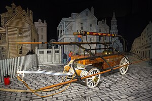
North Charleston Fire Museum
Fire Museum in North Charleston, SC
Distance: Approx. 873 meters
Latitude and longitude: 32.8707,-80.0184
The North Charleston Fire Museum and Educational Center is a fire museum in North Charleston, South Carolina, displaying a collection of fire fighting vehicles dating back to the 1780s. On permanent loan from the American LaFrance Company, which was headquartered nearby until its closure in 2014, the 20,000 square feet (1,900 m2) facility displays more than 20 restored vehicles, interactive exhibits and simulators. Established in 2007 by the city of North Charleston, the museum is a popular rainy day activity for tourists.
Weather in this IP's area
broken clouds
21 Celsius
22 Celsius
20 Celsius
23 Celsius
1013 hPa
94 %
1013 hPa
1012 hPa
10000 meters
75 %
06:58:59
19:37:11