104.192.248.26 - IP Lookup: Free IP Address Lookup, Postal Code Lookup, IP Location Lookup, IP ASN, Public IP
Country:
Region:
City:
Location:
Time Zone:
Postal Code:
IP information under different IP Channel
ip-api
Country
Region
City
ASN
Time Zone
ISP
Blacklist
Proxy
Latitude
Longitude
Postal
Route
Luminati
Country
Region
in
City
indianapolis
ASN
Time Zone
America/Indiana/Indianapolis
ISP
IPL-INTERNET1
Latitude
Longitude
Postal
IPinfo
Country
Region
City
ASN
Time Zone
ISP
Blacklist
Proxy
Latitude
Longitude
Postal
Route
IP2Location
104.192.248.26Country
Region
indiana
City
indianapolis
Time Zone
America/Indiana/Indianapolis
ISP
Language
User-Agent
Latitude
Longitude
Postal
db-ip
Country
Region
City
ASN
Time Zone
ISP
Blacklist
Proxy
Latitude
Longitude
Postal
Route
ipdata
Country
Region
City
ASN
Time Zone
ISP
Blacklist
Proxy
Latitude
Longitude
Postal
Route
Popular places and events near this IP address

United States District Court for the Southern District of Indiana
United States federal district court in Indiana
Distance: Approx. 187 meters
Latitude and longitude: 39.77055556,-86.15694444
The United States District Court for the Southern District of Indiana (in case citations, S.D. Ind.) is a federal district court in Indiana. It was created in 1928 by an act of Congress that split Indiana into two separate districts, northern and southern. The Southern District is divided into four divisions, Indianapolis, Terre Haute, Evansville, and New Albany.
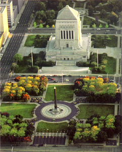
Indiana World War Memorial Plaza
Historic district in Indianapolis, Indiana, U.S.
Distance: Approx. 162 meters
Latitude and longitude: 39.77361111,-86.15694444
The Indiana World War Memorial Plaza is an urban feature and war memorial located in downtown Indianapolis, Indiana, United States, originally built to honor the veterans of World War I. It was conceived in 1919 as a location for the national headquarters of the American Legion and a memorial to the state's and nation's veterans. The original five-block plaza is bounded by Meridian Street (west), St. Clair Street (north), Pennsylvania Street (east), and New York Street (south).
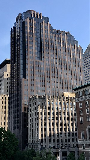
300 North Meridian
High-rise office building in Indianapolis, Indiana, U.S.
Distance: Approx. 181 meters
Latitude and longitude: 39.77138889,-86.15833333
300 North Meridian is a high rise in Indianapolis, Indiana. Construction started in 1987, financed by Browning Investments. The architects, Haldeman Miller Bregman Hamann (now BOKA Powell), built the outside with brownish-reddish granite and black windows, and capped the skyscraper with a copper-colored dome.

AT&T Building (Indianapolis)
High-rise office building in Indianapolis, Indiana, U.S.
Distance: Approx. 218 meters
Latitude and longitude: 39.77092778,-86.15843333
The AT&T Building is a high rise located at 240 North Meridian Street in Indianapolis, Indiana. It was opened in 1932 and is 22 stories tall. It is primarily used for office space and is the headquarters for AT&T in Indiana.
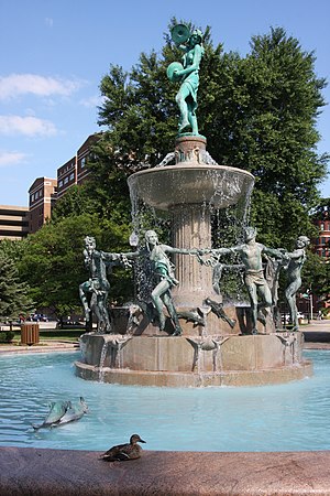
Depew Memorial Fountain
Fountain in Indianapolis, Indiana, U.S.
Distance: Approx. 47 meters
Latitude and longitude: 39.77194444,-86.15694444
Depew Memorial Fountain is a freestanding fountain completed in 1919 and located in University Park in downtown Indianapolis, Indiana, within the Indiana World War Memorial Plaza.

Birch Bayh Federal Building and United States Courthouse
United States historic place
Distance: Approx. 187 meters
Latitude and longitude: 39.77055556,-86.15694444
The Birch Bayh Federal Building and U.S. Courthouse, formerly known as the U.S. Courthouse and Post Office and as the Federal Building, is a courthouse of the United States District Court for the Southern District of Indiana, located in Indianapolis. It is a distinguished example of Beaux-Arts architecture, and was listed in the National Register of Historic Places in 1974. Constructed from 1902 to 1905, the United States District Court for the District of Indiana met here until it was subdivided in 1928; the United States Circuit Court for the District of Indiana met here until that court was abolished in 1912.
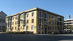
The Colonial (Indianapolis, Indiana)
United States historic place
Distance: Approx. 210 meters
Latitude and longitude: 39.77277778,-86.15416667
The Colonial is a historic apartment building located at Indianapolis, Indiana, United States. It was built in 1900, and is a three-story, eight bay by ten bay, Classical Revival style yellow brick building. It features a variety of terracotta decorative elements and two-story bay windows on the upper floors.: Part 2, p.
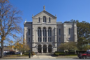
Roberts Park Methodist Episcopal Church
Historic church in Indiana, United States
Distance: Approx. 232 meters
Latitude and longitude: 39.77277778,-86.15388889
Roberts Park Methodist Episcopal Church, whose present-day name is Roberts Park United Methodist Church, was dedicated on August 27, 1876, making it one of the oldest church remaining in downtown Indianapolis. Diedrich A. Bohlen, a German-born architect who immigrated to Indianapolis in the 1850s, designed this early example of Romanesque Revival architecture. The church is considered one of Bohlen's major works.
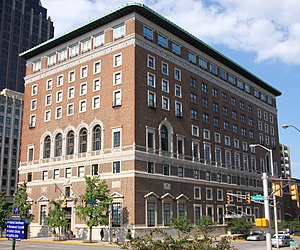
Indianapolis Athletic Club
United States historic place
Distance: Approx. 114 meters
Latitude and longitude: 39.7725,-86.15777778
The Indianapolis Athletic Club was founded in 1886 and quickly became a premiere private club for Indiana businessmen and society elite. It was especially active in Indiana Democratic politics. Credited with fielding one of the first football teams in Indiana and hosting many of the earliest games, it also promoted baseball and boxing matches.

The Blacherne
Apartment building in Indiana, US
Distance: Approx. 148 meters
Latitude and longitude: 39.77277778,-86.15805556
The Blacherne is a historic apartment building located in Indianapolis, Indiana, United States. It was built in 1895 and is a large seven-story, 6 bay by 15 bay, red pressed brick building on a limestone foundation. It features two circular projecting bays at the corners and a semicircular limestone Romanesque Revival style entry portal.: Part 1, p.
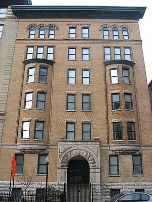
The Savoy (Indianapolis, Indiana)
United States historic place
Distance: Approx. 214 meters
Latitude and longitude: 39.77277778,-86.15888889
The Savoy is a historic apartment building located at Indianapolis, Indiana. It was built in 1898, and is a six-story, three-bay-wide, buff-colored brick building on a raised basement. It has rock faced arched entrance, oriel windows on the second through fourth floors, Romanesque Revival style arched windows on the top floor, and a projecting cornice.: Part 1, p.

Colfax Memorial
Sculpture in Indianapolis, Indiana, U.S.
Distance: Approx. 28 meters
Latitude and longitude: 39.772,-86.1567
The Colfax Memorial is an outdoor sculpture of Schuyler Colfax, installed in Indianapolis, Indiana.
Weather in this IP's area
broken clouds
4 Celsius
0 Celsius
3 Celsius
5 Celsius
1011 hPa
87 %
1011 hPa
984 hPa
10000 meters
5.66 m/s
280 degree
75 %