Country:
 Canada
Region:
City:
Latitude and Longitude:
Time Zone:
Postal Code:
IP information under different IP Channel
ip-api
Country
Region
City
ASN
Time Zone
ISP
Blacklist
Proxy
Latitude
Longitude
Postal
Route
IPinfo
Country
Region
City
ASN
Time Zone
ISP
Blacklist
Proxy
Latitude
Longitude
Postal
Route
MaxMind
Country
Region
City
ASN
Time Zone
ISP
Blacklist
Proxy
Latitude
Longitude
Postal
Route
Luminati
Country
CAASN
Time Zone
America/Toronto
ISP
ROGERS-COMMUNICATIONS
Latitude
Longitude
Postal
db-ip
Country
Region
City
ASN
Time Zone
ISP
Blacklist
Proxy
Latitude
Longitude
Postal
Route
ipdata
Country
Region
City
ASN
Time Zone
ISP
Blacklist
Proxy
Latitude
Longitude
Postal
Route
Popular places and events near this IP address

Ottawa West—Nepean
Federal electoral district in Ontario, Canada
Distance: Approx. 757 meters
Latitude and longitude: 45.35,-75.78333333
Ottawa West—Nepean (French: Ottawa-Ouest—Nepean) is a federal electoral district in Ontario, Canada, that has been represented in the House of Commons of Canada since 1997.
Pinecrest Public School
Elementary school in Ottawa, Ontario, Canada
Distance: Approx. 625 meters
Latitude and longitude: 45.343859,-75.784904
Pinecrest Public School is a public elementary school in Ottawa, Ontario, Canada.
Ottawa–Rideau
Electoral district in Ontario, Canada
Distance: Approx. 757 meters
Latitude and longitude: 45.35,-75.78333333
Ottawa–Rideau was a short lived provincial electoral district in Ottawa, Ontario. It elected one member to the Legislative Assembly of Ontario. It was created in 1987 and was abolished in 1999 into Ottawa South, Nepean–Carleton, Ottawa West–Nepean and Ottawa Centre.
St. Paul High School (Ottawa)
Separate high school in Ottawa, Ontario, Canada
Distance: Approx. 557 meters
Latitude and longitude: 45.341741,-75.792779
St. Paul High School is a Catholic high school in Ottawa, Ontario, Canada.
Ottawa West—Nepean (provincial electoral district)
Provincial electoral district of Ontario
Distance: Approx. 757 meters
Latitude and longitude: 45.35,-75.78333333
Ottawa West—Nepean (French: Ottawa-Ouest–Nepean) is a provincial electoral district in eastern Ontario, Canada. It elects one member to the Legislative Assembly of Ontario. The riding is represented in the Ontario legislature by the NDP's Chandra Pasma.
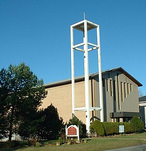
St. Stephen's Anglican Church (Ottawa)
Church
Distance: Approx. 900 meters
Latitude and longitude: 45.35458,-75.79438
St. Stephen's Anglican Church is an Anglican Church of Canada parish in Ottawa, Ontario, Canada.
Qualicum-Graham Park
Distance: Approx. 1114 meters
Latitude and longitude: 45.33893,-75.80077
Qualicum-Graham Park or Qualicum is a suburban neighbourhood in College Ward in the City of Ottawa, Ontario, Canada. It is located in the former City of Nepean in the west end of the city. Many of the residences in the area are executive homes situated on large lots (100x100) being built in the 1960s.
Redwood, Ottawa
Neighbourhood in Ottawa, Ontario, Canada
Distance: Approx. 273 meters
Latitude and longitude: 45.344545,-75.793476
Redwood is a neighbourhood located in Ottawa's west end. The boundaries of the neighbourhood is Greenbank Road to the east, Baseline Road to the south, Morrison Drive (old Ottawa-Nepean border line) to the west and Highway 417 to the north. Its sister neighbourhoods are Qualicum, Leslie Park, and Queensway Terrace.
Foster Farm
Neighbourhood in Ottawa, Ontario, Canada
Distance: Approx. 484 meters
Latitude and longitude: 45.35,-75.79583333
Foster Farm, nicknamed "the Farm", is a neighbourhood in the Britannia area of Bay Ward in the west end of Ottawa, Ontario, Canada. It is roughly bounded to the north by Richmond Road, to the east by Pinecrest Road, to the west by the former Ottawa/Nepean city limits and the south by the Highway 417, the Queensway. It is bordered by Fairfield Heights, Queensway Terrace North, Redwood, Michele Heights.

Queensway Terrace South
Neighbourhood in Ottawa, Ontario, Canada
Distance: Approx. 576 meters
Latitude and longitude: 45.34527778,-75.78472222
Queensway Terrace South is a neighbourhood in College Ward in the west end of Ottawa, Ontario, Canada. It used to be part of Queensway Terrace but in 1967, Highway 417 was built and split apart into Queensway Terrace North and South. The borders are to the east Southwood Drive, to the south Baseline Road, Queensway (Highway 417) to the north and Greenbank Road to the west.

Ridgeview, Ottawa
Neighbourhood in Ottawa, Ontario, Canada
Distance: Approx. 1012 meters
Latitude and longitude: 45.348,-75.779
Ridgeview is a neighbourhood in College Ward in the west end of Ottawa, Ontario, Canada. It is bordered to the south by Baseline Road, to the east by Cobden Road, to the North by the Queensway, and to the west by Southwood Drive. It was developed in the 1960s along with Parkway Park.

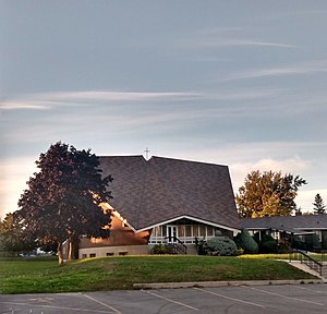
Britannia United Church
Church in Ottawa, Ontario
Distance: Approx. 801 meters
Latitude and longitude: 45.35388889,-75.79222222
Britannia United Church is a United Church of Canada congregation in Ottawa, Ontario, Canada. One of Ottawa's oldest congregations, members had been meeting in homes since 1869. The Britannia Heights Methodist Church formed in 1873.
Weather in this IP's area
clear sky
13 Celsius
12 Celsius
11 Celsius
14 Celsius
1032 hPa
62 %
1032 hPa
1024 hPa
10000 meters
2.57 m/s
290 degree
07:23:40
18:12:26