Country:
 USA
USARegion:
City:
Latitude and Longitude:
Time Zone:
Postal Code:
IP information under different IP Channel
ip-api
Country
Region
City
ASN
Time Zone
ISP
Blacklist
Proxy
Latitude
Longitude
Postal
Route
IPinfo
Country
Region
City
ASN
Time Zone
ISP
Blacklist
Proxy
Latitude
Longitude
Postal
Route
MaxMind
Country
Region
City
ASN
Time Zone
ISP
Blacklist
Proxy
Latitude
Longitude
Postal
Route
Luminati
db-ip
Country
Region
City
ASN
Time Zone
ISP
Blacklist
Proxy
Latitude
Longitude
Postal
Route
ipdata
Country
Region
City
ASN
Time Zone
ISP
Blacklist
Proxy
Latitude
Longitude
Postal
Route
Popular places and events near this IP address
American Registry for Internet Numbers
Regional Internet Registry representing North America and the Caribbean
Distance: Approx. 798 meters
Latitude and longitude: 38.91052778,-77.44325
The American Registry for Internet Numbers (ARIN) is the regional Internet registry for the United States, Canada, and many Caribbean and North Atlantic islands. ARIN manages the distribution of Internet number resources, including IPv4 and IPv6 address space and AS numbers. ARIN opened for business on December 22, 1997 after incorporating on April 18, 1997.
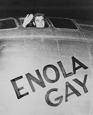
Enola Gay
US Army Air Forces Boeing B-29 airplane that dropped the first atomic bomb
Distance: Approx. 721 meters
Latitude and longitude: 38.9108,-77.4442
The Enola Gay () is a Boeing B-29 Superfortress bomber, named after Enola Gay Tibbets, the mother of the pilot, Colonel Paul Tibbets. On 6 August 1945, during the final stages of World War II, it became the first aircraft to drop an atomic bomb in warfare. The bomb, code-named "Little Boy", was targeted at the city of Hiroshima, Japan, and destroyed about three-quarters of the city.

National Reconnaissance Office
US intelligence agency in charge of satellite intelligence
Distance: Approx. 3095 meters
Latitude and longitude: 38.88194444,-77.45027778
The National Reconnaissance Office (NRO) is a member of the United States Intelligence Community and an agency of the United States Department of Defense which designs, builds, launches, and operates the reconnaissance satellites of the U.S. federal government. It provides satellite intelligence to several government agencies, particularly signals intelligence (SIGINT) to the NSA, imagery intelligence (IMINT) to the NGA, and measurement and signature intelligence (MASINT) to the DIA. The NRO announced in 2023 that it plans within the following decade to quadruple the number of satellites it operates and increase the number of signals and images it delivers by a factor of ten. NRO is considered, along with the Central Intelligence Agency (CIA), National Security Agency (NSA), Defense Intelligence Agency (DIA), and National Geospatial-Intelligence Agency (NGA), to be one of the "big five" U.S. intelligence agencies.

Steven F. Udvar-Hazy Center
Aviation museum in Virginia, U.S.
Distance: Approx. 738 meters
Latitude and longitude: 38.91138889,-77.44416667
The Steven F. Udvar-Hazy Center, also called the Udvar-Hazy Center, is the Smithsonian National Air and Space Museum (NASM)'s annex at Dulles International Airport in the Chantilly area of Fairfax County, Virginia. It holds numerous exhibits, including the Space Shuttle Discovery, the Enola Gay, and the Boeing 367-80, the main prototype for the popular Boeing 707 airliner. The 760,000-square-foot (71,000 m2; 17-acre; 7.1 ha) facility was made possible by a $65 million donation in October 1999 to the Smithsonian Institution by Steven F. Udvar-Házy, an immigrant from Hungary and co-founder of the International Lease Finance Corporation, an aircraft leasing corporation.

Westfield High School (Virginia)
High school in Chantilly, Virginia, United States
Distance: Approx. 2904 meters
Latitude and longitude: 38.88527778,-77.46416667
Westfield High School is a public high school in unincorporated Fairfax County, Virginia, United States, west of the Chantilly CDP. It is a part of Fairfax County Public Schools (FCPS), serving students from the communities including Chantilly and Centreville as well as areas with Herndon addresses in grades 9–12. Opened in 2000, it is the head of the Westfield High School Pyramid in Cluster VIII. Westfield's main building has the same layout as South County High School (Fairfax County, Virginia). At 3,260 students, it is one of the largest four-year high schools in the Commonwealth of Virginia.
The Meteoritical Society
Distance: Approx. 89 meters
Latitude and longitude: 38.90890833,-77.45224722
The Meteoritical Society is a non-profit scholarly organization founded in 1933 to promote research and education in planetary science with emphasis on studies of meteorites and other extraterrestrial materials that further our understanding of the origin and history of the Solar System.
National Captioning Institute
American nonprofit organization
Distance: Approx. 405 meters
Latitude and longitude: 38.90885,-77.447857
The National Captioning Institute, Inc. (NCI) is a 501(c)(3) nonprofit organization that provides real-time and off-line closed captioning, subtitling and translation, described video, web captioning, and Spanish captioning for television and films. Created in 1979 and headquartered in Chantilly, Virginia, the organization was the first to caption live TV and home video, and holds the trademark on the display icon featuring a simple geometric rendering of a television set merged with a speech balloon to indicate that a program is captioned by National Captioning Institute.
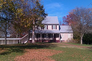
Sully Historic Site
Historic house in Virginia, United States
Distance: Approx. 1757 meters
Latitude and longitude: 38.90805556,-77.43222222
Sully Historic Site, is both a Virginia landmark and nationally registered historic place in Chantilly, Virginia. The earliest recorded claim to the land was made by the Doeg. Later the Lee family of Virginia owned the land from 1725 to 1839.

CIA University
Training facility of the U.S. Central Intelligence Agency
Distance: Approx. 2362 meters
Latitude and longitude: 38.9178,-77.4272
CIA University (CIAU) is the primary education facility of the U.S. Central Intelligence Agency (CIA). Founded in 2002 and located in Chantilly, Virginia, the school holds courses on various intelligence-related subjects, ranging from chemical weapons manufacturing to foreign languages. Students include CIA new hires, experienced officers, support staff, and individuals from other U.S. intelligence agencies.

Church of the Epiphany (Virginia)
Church in Virginia , United States
Distance: Approx. 2391 meters
Latitude and longitude: 38.89777778,-77.42944444
The Church of the Epiphany is an Anglican church located in Chantilly, Virginia. It emphasizes "Encountering God through beautiful worship and believing prayer, building a multigenerational congregation that loves children and families and equipping every member to share the good news of Jesus Christ." Notable ministries and activities include a yearly free "Sports Camp" in Herndon for elementary-age students, bi-weekly worship and other ministry activities at the Arbor Terrace memory care home in Chantilly, and monthly donations of food that go home with students in need at Coates Elementary School in Herndon. Each year, Epiphany designates the congregation's Christmas Eve offering to a special project, alternating between supporting mission outside of the United States and meeting local needs in Fairfax County.
NAVWAR Space Field Activity
Echelon III activity of the United States Navy
Distance: Approx. 3095 meters
Latitude and longitude: 38.88194444,-77.45027778
The NAVWAR Space Field Activity (NSFA) is one of three Echelon III activities under the Naval Information Warfare Systems Command (NAVWARSYSCOM) of the United States Navy, co-located with the National Reconnaissance Office (NRO) in Chantilly, Virginia. The activity was established to coordinate naval space and warfare systems activities within the National Reconnaissance Office. NSFA personnel provide naval warfare and acquisition expertise to national reconnaissance programs, coordinate naval space research, development, and acquisition activities with those same national reconnaissance programs, and provide and coordinate training and tools to enable the fleet to use national space capabilities.
Sully Square, Virginia
Census-designated place in Virginia
Distance: Approx. 2547 meters
Latitude and longitude: 38.918,-77.425
Sully Square is a census designated place in Fairfax County, Virginia, United States.
Weather in this IP's area
broken clouds
19 Celsius
19 Celsius
18 Celsius
21 Celsius
1012 hPa
58 %
1012 hPa
1002 hPa
10000 meters
5.14 m/s
320 degree
75 %
07:11:41
18:43:01