Country:
 Netherlands
Region:
City:
Latitude and Longitude:
Time Zone:
Postal Code:
IP information under different IP Channel
ip-api
Country
Region
City
ASN
Time Zone
ISP
Blacklist
Proxy
Latitude
Longitude
Postal
Route
IPinfo
Country
Region
City
ASN
Time Zone
ISP
Blacklist
Proxy
Latitude
Longitude
Postal
Route
MaxMind
Country
Region
City
ASN
Time Zone
ISP
Blacklist
Proxy
Latitude
Longitude
Postal
Route
Luminati
Country
 US
USRegion
va
ASN
Time Zone
America/New_York
ISP
M247 Europe SRL
Latitude
Longitude
Postal
db-ip
Country
Region
City
ASN
Time Zone
ISP
Blacklist
Proxy
Latitude
Longitude
Postal
Route
ipdata
Country
Region
City
ASN
Time Zone
ISP
Blacklist
Proxy
Latitude
Longitude
Postal
Route
Popular places and events near this IP address

Batavian Republic
Dutch predecessor state, 1795–1806
Distance: Approx. 429 meters
Latitude and longitude: 52.06666667,4.3
The Batavian Republic (Dutch: Bataafse Republiek; French: République Batave) was the successor state to the Republic of the Seven United Netherlands. It was proclaimed on 19 January 1795 and ended on 5 June 1806, with the accession of Louis Bonaparte to the Dutch throne. From October 1801 onward, it was known as the Batavian Commonwealth (Dutch: Bataafs Gemenebest).
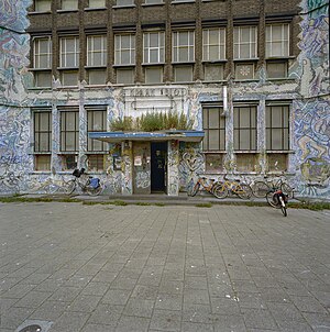
De Blauwe Aanslag
Demolished building in The Hague
Distance: Approx. 73 meters
Latitude and longitude: 52.07111,4.30111
De Blauwe Aanslag was a squat and self-managed social centre in the Dutch city of The Hague. The oldest part of the building was built in 1886. The large building formerly housed tax offices and was occupied in 1980.

The Hague Center
District of The Hague in South Holland, Netherlands
Distance: Approx. 835 meters
Latitude and longitude: 52.0706,4.3129
The City Center of The Hague (Dutch: Centrum) is the oldest and, with a population of 104,658 inhabitants (as of 1 January 2018), the second largest of The Hague's eight districts, consisting of nine neighbourhoods. Two railways stations can be found in the city center: Den Haag Centraal and Den Haag Hollands Spoor.

Paard van Troje
Venue in The Hague, Netherlands
Distance: Approx. 661 meters
Latitude and longitude: 52.07472222,4.3075
Paard van Troje (Dutch for Trojan Horse), since 2016 known as PAARD, is a venue in The Hague, Netherlands founded in 1972 18 June with the support of the alderman of culture from The Hague. Currently located at the Prinsegracht.

Grote Markt RandstadRail station
RandstadRail station and tram stop in The Hague
Distance: Approx. 752 meters
Latitude and longitude: 52.075,4.30888889
Grote Markt is a RandstadRail station in central The Hague, Netherlands. It opened on 16 October 2004 as part of The Hague's new tram tunnel. The station is near by the Grote Marktstraat where's the main shopping centre from The Hague.

Brouwersgracht RandstadRail station
Railway station in The Hague, Netherlands
Distance: Approx. 409 meters
Latitude and longitude: 52.07361111,4.30388889
Brouwersgracht is a RandstadRail stop in The Hague, Netherlands.
HMC Westeinde RandstadRail station
Distance: Approx. 268 meters
Latitude and longitude: 52.07277778,4.29944444
HMC Westeinde is a RandstadRail stop in The Hague, Netherlands.

Monstersestraat RandstadRail station
Distance: Approx. 646 meters
Latitude and longitude: 52.07305556,4.29222222
Monstersestraat is a RandstadRail stop in The Hague, Netherlands.
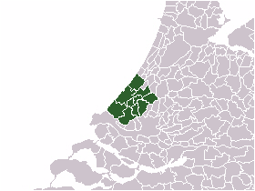
Haaglanden
Former official urban region in the Netherlands
Distance: Approx. 590 meters
Latitude and longitude: 52.0658,4.2967
Parts of this article have been translated from the Dutch version of this page Haaglanden (Dutch pronunciation: [ˈɦaːxlɑndə(n)], literally Haguelands) was a conurbation surrounding The Hague in the Netherlands from 1992 until 2015. The city's position as the country's seat of government made the region prominent in the Netherlands. Located on the west coast of the province of South Holland, the region had a population of 1,050,543 in September 2013, and covered an area of 405 km².

Adrianus Jacobus Zuyderland
Model of Vincent van Gogh
Distance: Approx. 439 meters
Latitude and longitude: 52.0719,4.3067
Adrianus Jacobus Zuyderland was Vincent van Gogh's favorite model during his Hague period. He appears in dozens of drawings, easily identified by his bald head and prominent white whiskers, and he was the model for the drawing which was the basis for van Gogh's later iconic painting At Eternity's Gate.

Boterwaag
Weigh house in The Hague
Distance: Approx. 759 meters
Latitude and longitude: 52.07527778,4.30861111
The Boterwaag is a former weigh house for butter in The Hague, Netherlands. The right half is a café.

Design Museum Dedel
Museum in The Hague, the Netherlands
Distance: Approx. 705 meters
Latitude and longitude: 52.07516389,4.30766944
Design Museum Dedel is a museum located in The Hague. The museum hosts thematic exhibitions of two-dimensional design, including graphic design, posters, wallpaper - and has included posters from the collection of the former Poster Museum in Hoorn and objects (including posters) from the collection of the ReclameArsenaal. The museum was opened on July 1, 2019 by Mrs.
Weather in this IP's area
few clouds
15 Celsius
15 Celsius
14 Celsius
16 Celsius
997 hPa
92 %
997 hPa
996 hPa
10000 meters
6.17 m/s
210 degree
20 %
07:55:51
19:04:22