Country:
 USA
USARegion:
City:
Latitude and Longitude:
Time Zone:
Postal Code:
IP information under different IP Channel
ip-api
Country
Region
City
ASN
Time Zone
ISP
Blacklist
Proxy
Latitude
Longitude
Postal
Route
IPinfo
Country
Region
City
ASN
Time Zone
ISP
Blacklist
Proxy
Latitude
Longitude
Postal
Route
MaxMind
Country
Region
City
ASN
Time Zone
ISP
Blacklist
Proxy
Latitude
Longitude
Postal
Route
Luminati
Country
USASN
Time Zone
America/Chicago
ISP
AS-WAVE-1
Latitude
Longitude
Postal
db-ip
Country
Region
City
ASN
Time Zone
ISP
Blacklist
Proxy
Latitude
Longitude
Postal
Route
ipdata
Country
Region
City
ASN
Time Zone
ISP
Blacklist
Proxy
Latitude
Longitude
Postal
Route
Popular places and events near this IP address

San Jose, California
City in California, United States
Distance: Approx. 248 meters
Latitude and longitude: 37.33611111,-121.89055556
San Jose, officially the City of San José (Spanish for 'Saint Joseph' SAN hoh-ZAY, -SAY; Spanish: [saŋ xoˈse]), is the largest city in Northern California by both population and area. With a 2022 population of 971,233, it is the most populous city in both the Bay Area and the San Jose–San Francisco–Oakland Combined Statistical Area—which in 2022 had a population of 7.5 million and 9.0 million respectively—the third-most populous city in California after Los Angeles and San Diego, and the 13th-most populous in the United States. Located in the center of the Santa Clara Valley on the southern shore of San Francisco Bay, San Jose covers an area of 179.97 sq mi (466.1 km2).
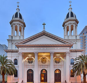
Cathedral Basilica of St. Joseph (San Jose)
Historic church in California, United States
Distance: Approx. 106 meters
Latitude and longitude: 37.334036,-121.890816
The Cathedral Basilica of St. Joseph (Spanish: Catedral Basílica de San José) is a historic Catholic church in Downtown San Jose that serves as the cathedral for the Diocese of San José in California, with the distinction of minor basilica. The basilica is named for Saint Joseph, patron saint of the Catholic Church and the namesake of San Jose, California.

San Jose Museum of Art
Contemporary art museum in San Jose, California, U.S.
Distance: Approx. 165 meters
Latitude and longitude: 37.333488,-121.890364
The San José Museum of Art (SJMA) is a modern and contemporary art museum in downtown San Jose, California, United States. Founded in 1969, the museum holds a permanent collection with an emphasis on West Coast artists of the 20th and 21st centuries. It is located at Circle of Palms Plaza, beside Plaza de César Chávez.

Tower 55
Commercial offices, Data center in San Jose, California
Distance: Approx. 35 meters
Latitude and longitude: 37.3342,-121.8916
Tower 55 (formerly the Market Post Tower; also known as the Gold Building or simply 55 South Market) is a 15-story building at the corner of South Market Street and Post Street in downtown San Jose, California. Built in 1985 as the Market Post Tower, it was designed to provide a mix of office and retail space. When first built, the building was controversial due to its gold-colored glass exterior, which produced high light and heat reflection.
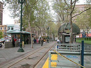
Santa Clara station (VTA)
VTA light rail station in San Jose, California
Distance: Approx. 251 meters
Latitude and longitude: 37.3358,-121.89
Santa Clara station is a light rail station operated by Santa Clara Valley Transportation Authority (VTA) located in the Historic District of Downtown San Jose, California on 1st and 2nd Streets just south of Santa Clara Street. The northbound platform is on 1st Street; the southbound platform is on 2nd Street. The platforms are connected via a pedestrian paseo called Fountain Alley.
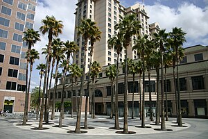
Circle of Palms Plaza
Plaza in San Jose, California, US
Distance: Approx. 227 meters
Latitude and longitude: 37.33343,-121.889627
The Circle of Palms Plaza is located in downtown San Jose, California. It is composed of a ring of palm trees encircling a California State Seal, and designates the California Historical Marker 461, the site of California's first state capital from 1849 to 1851.

Bank of Italy Building (San Jose, California)
Commercial offices in San Jose, California
Distance: Approx. 251 meters
Latitude and longitude: 37.3358,-121.89
The Bank of Italy Building is a 14-story, 77.72 m (255.0 ft) Renaissance Revival high-rise built in 1925 in downtown San Jose, California. This building became the second home to the first branch of the Bank of Italy, founded in San Francisco in 1904, which later became the Bank of America. The first location of the Bank of Italy in San Jose, was on the corner of Santa Clara St.
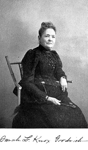
Sarah Knox-Goodrich
American suffragist
Distance: Approx. 254 meters
Latitude and longitude: 37.33560278,-121.88973611
Sarah L. Knox-Goodrich (February 14, 1825 – October 30, 1903) was a women's rights activist who worked for women's suffrage in California in the late nineteenth century. Her first husband, William Knox, was a business man, banker, and state politician. Her second husband, Levi Goodrich, was an architect in Southern California.

San Jose electric light tower
Distance: Approx. 144 meters
Latitude and longitude: 37.335488,-121.892074
The San Jose electric light tower, also known as Owen's Electric Tower after its creator and chief booster, was constructed in 1881 at an intersection in downtown San Jose, California, as a "high light" or moonlight tower to light the city using arc lights. A pioneer use of electricity for municipal lighting, it was later strung with incandescent bulbs and was destroyed in a storm in December 1915. A half-size replica stands at History Park at Kelley Park.

Qmunity District
Neighborhood of San Jose in California, United States
Distance: Approx. 146 meters
Latitude and longitude: 37.334937,-121.890634
The Qmunity District is a gay neighborhood located in Downtown San Jose, California.
San Jose Chamber of Commerce
Distance: Approx. 94 meters
Latitude and longitude: 37.335,-121.89166667
The San Jose Chamber of Commerce, is a chamber of commerce representing business interests in the Greater San Jose, California Area. It is the largest chamber of commerce in the Silicon Valley region. Founded in 1886, the chamber has played a role in the development of the local economy and politics.
Market Street Chinatown
Neighborhood of San Jose in Santa Clara, California, United States
Distance: Approx. 224 meters
Latitude and longitude: 37.33333333,-121.88972222
Market Street Chinatown (Chinese: 孖結街唐人埠) or Plaza Chinatown refers to two successive Chinatowns in San Jose, California, during the 19th century. Both were destroyed by arson with the tacit support of officials. The site was rediscovered during a 1980s redevelopment project, shedding light on an era when San Jose led the state of California in anti-Chinese violence.
Weather in this IP's area
clear sky
16 Celsius
16 Celsius
13 Celsius
18 Celsius
1011 hPa
84 %
1011 hPa
1008 hPa
10000 meters
0.89 m/s
1.34 m/s
283 degree
06:44:27
19:25:58