Country:
 Canada
Region:
City:
Latitude and Longitude:
Time Zone:
Postal Code:
IP information under different IP Channel
ip-api
Country
Region
City
ASN
Time Zone
ISP
Blacklist
Proxy
Latitude
Longitude
Postal
Route
IPinfo
Country
Region
City
ASN
Time Zone
ISP
Blacklist
Proxy
Latitude
Longitude
Postal
Route
MaxMind
Country
Region
City
ASN
Time Zone
ISP
Blacklist
Proxy
Latitude
Longitude
Postal
Route
Luminati
Country
CAASN
Time Zone
America/Toronto
ISP
FIBRENOIRE-INTERNET
Latitude
Longitude
Postal
db-ip
Country
Region
City
ASN
Time Zone
ISP
Blacklist
Proxy
Latitude
Longitude
Postal
Route
ipdata
Country
Region
City
ASN
Time Zone
ISP
Blacklist
Proxy
Latitude
Longitude
Postal
Route
Popular places and events near this IP address
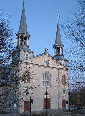
Charlesbourg, Quebec City
Borough of Quebec City in Canada
Distance: Approx. 1511 meters
Latitude and longitude: 46.867,-71.267
Charlesbourg is a borough of Quebec City, in the northeastern part of the city, west of the borough of Beauport.
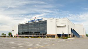
Colisée de Québec
Multi-purpose arena in Quebec City
Distance: Approx. 5832 meters
Latitude and longitude: 46.83083333,-71.24638889
Colisée de Québec (later known as Colisée Pepsi, meaning "Pepsi Coliseum") was a multi-purpose arena located in Quebec City, Quebec. It was the home of the Quebec Nordiques from 1972 to 1995, during their time in the World Hockey Association and National Hockey League. It was also the home of the Quebec Remparts of the Quebec Major Junior Hockey League from 1999 until its closing in 2015.
Saint-Émile, Quebec City
Place in Quebec
Distance: Approx. 4908 meters
Latitude and longitude: 46.87075,-71.33758333
Saint-Émile is a former city in central Quebec, Canada. It was amalgamated into Quebec City on January 1, 2002. It is located within the Borough of La Haute-Saint-Charles.

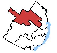
Beauport—Limoilou
Federal electoral district in Quebec, Canada
Distance: Approx. 5834 meters
Latitude and longitude: 46.842,-71.221
Beauport—Limoilou is a federal electoral district in Quebec City, Quebec, Canada, that has been represented in the House of Commons of Canada since 2004. The riding was created in 2003 as "Beauport" from parts of Beauport—Montmorency—Côte-de-Beaupré—Île-d'Orléans, Quebec and Quebec East ridings. It was renamed "Beauport—Limoilou" after the 2004 election.
Charlesbourg—Haute-Saint-Charles
Federal electoral district in Quebec, Canada
Distance: Approx. 3363 meters
Latitude and longitude: 46.9,-71.307
Charlesbourg—Haute-Saint-Charles (formerly Charlesbourg and Charlesbourg—Jacques Cartier) is a federal electoral district in Quebec, Canada, that has been represented in the House of Commons of Canada since 1979.
CHRC (AM)
Former radio station in Quebec City, Quebec
Distance: Approx. 5832 meters
Latitude and longitude: 46.83083333,-71.24638889
CHRC was a French language radio station located in Quebec City, Quebec, Canada. Known as Québec 800, the station had a news/talk/sports format. Founded in 1926, it was the oldest station in Quebec City at the time of its shutdown.

Charlesbourg (provincial electoral district)
Provincial electoral district in Quebec, Canada
Distance: Approx. 1555 meters
Latitude and longitude: 46.86666667,-71.26666667
Charlesbourg is a provincial electoral district in the Capitale-Nationale region of Quebec, Canada that elects members to the National Assembly of Quebec. It consists of part of the Charlesbourg borough of Quebec City. It was created for the 1973 election from parts of Chauveau and Montmorency electoral districts.
Quebec County, Quebec
Distance: Approx. 2442 meters
Latitude and longitude: 46.86,-71.26
Quebec County was a historic county in the province of Quebec, Canada. The county included the Quebec City metropolitan area and extended northwestward. The county seat was Loretteville.
Lac-Saint-Charles–Saint-Émile
Distance: Approx. 5767 meters
Latitude and longitude: 46.88333333,-71.35
Lac-Saint-Charles–Saint-Émile is the northernmost district of Quebec City located in the borough of La Haute-Saint-Charles. The district was created following an electoral reorganization in 2009. Before the 2000–2006 municipal reorganization in Quebec, the area was occupied by the cities of Saint-Émile and Lac-Saint-Charles.

Rivière des Roches (rivière du Berger)
Tributary of Saint-Charles River in Québec, Canada
Distance: Approx. 2090 meters
Latitude and longitude: 46.89555556,-71.28888889
The Rivière des Roches is a tributary of the rivière du Berger flowing in the sectors Beauport and Charlesbourg in Quebec City, in the region of Capitale-Nationale, in the province of Quebec, in Canada. Taking its source in the Lac des Roches, it has a length of approximately 5.3 km. The valley of the Roches river does not have a road except its upper part which is served east of Lac des Roches by Arthur-Drolet road and northeast by Lac-des-Roches road.
Rivière des Sept Ponts
Tributary of "rivière du Berger" in Québec, Canada
Distance: Approx. 2813 meters
Latitude and longitude: 46.89666667,-71.30166667
The rivière des Sept Ponts (English: river of the seven bridges) is a tributary of the rivière du Berger flowing in the sectors of Beauport and Charlesbourg, in Quebec City, Quebec, Canada. The upper part of the valley of the Sept Ponts river does not have a road. Its lower part, downstream from Lac Bégon, is located mainly in urban areas and is mainly served by Boulevard Henri-Bourassa, Rue Sophia Melvin and Rue des Nations Est.
Lac des Roches
Lake in Capitale-Nationale, Quebec, Canada
Distance: Approx. 4941 meters
Latitude and longitude: 46.92111111,-71.25138889
The Lac des Roches (English: lake of rocks) is a freshwater body of the city of Quebec, in the region of the Capitale-Nationale, in the province of Quebec, in Canada. It is the main reserve of drinking water in the arrondissement of Charlesbourg. Lac des Roches is mainly fed by five forest streams from the surrounding mountains.
Weather in this IP's area
few clouds
11 Celsius
10 Celsius
10 Celsius
13 Celsius
1031 hPa
65 %
1031 hPa
1015 hPa
10000 meters
1.54 m/s
20 %
07:07:41
17:52:17