104.156.164.35 - IP Lookup: Free IP Address Lookup, Postal Code Lookup, IP Location Lookup, IP ASN, Public IP
Country:
Region:
City:
Location:
Time Zone:
Postal Code:
ISP:
ASN:
language:
User-Agent:
Proxy IP:
Blacklist:
IP information under different IP Channel
ip-api
Country
Region
City
ASN
Time Zone
ISP
Blacklist
Proxy
Latitude
Longitude
Postal
Route
db-ip
Country
Region
City
ASN
Time Zone
ISP
Blacklist
Proxy
Latitude
Longitude
Postal
Route
IPinfo
Country
Region
City
ASN
Time Zone
ISP
Blacklist
Proxy
Latitude
Longitude
Postal
Route
IP2Location
104.156.164.35Country
Region
california
City
goleta
Time Zone
America/Los_Angeles
ISP
Language
User-Agent
Latitude
Longitude
Postal
ipdata
Country
Region
City
ASN
Time Zone
ISP
Blacklist
Proxy
Latitude
Longitude
Postal
Route
Popular places and events near this IP address

Deckers Brands
Consumer retail company
Distance: Approx. 458 meters
Latitude and longitude: 34.4296,-119.86202
Deckers Outdoor Corporation, doing business as Deckers Brands, is a footwear designer and distributor based in Goleta, California, United States. It was founded in 1973 by University of California, Santa Barbara alumni Doug Otto and Karl F. Lopker. In 1975, the company was incorporated in California under the name Deckers Corporation.
Harder Stadium
Stadium in Santa Barbara, California, US
Distance: Approx. 1709 meters
Latitude and longitude: 34.42,-119.854
Harder Stadium is a 17,000-seat, outdoor multi-purpose stadium on the west coast of the United States, on the campus of the University of California, Santa Barbara in Santa Barbara, California. It serves as the on-campus soccer stadium for both the UC Santa Barbara Gauchos men's and women's programs and also for Santa Barbara Sky of the USL Championship beginning 2026. Currently used occasionally by the university's club rugby and lacrosse teams, it was originally the home of the defunct football program.
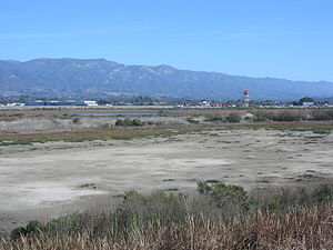
Goleta Slough
Wetland in Santa Barbara County, California
Distance: Approx. 1758 meters
Latitude and longitude: 34.42382222,-119.84746111
The Goleta Slough is an area of estuary, tidal creeks, tidal marsh, and wetlands near Goleta, California, United States. It primarily consists of the filled and unfilled remnants of the historic inner Goleta Bay about 8 miles (13 km) west of Santa Barbara. The slough empties into the Pacific Ocean through an intermittently closed mouth at Goleta Beach County Park just east of the UCSB campus and Isla Vista.

Dos Pueblos High School
Public school in Goleta, California, United States
Distance: Approx. 1581 meters
Latitude and longitude: 34.43812,-119.87876
Dos Pueblos High School is a public high school located in Goleta, California, northwest of Santa Barbara. Located adjacent to the foothills on the edge of the Goleta Valley in an area known as El Encanto Heights, it serves a student body of approximately 2,300 in grades 9-12. It is one of three comprehensive high schools in the Santa Barbara Unified School District.

Las Cumbres Observatory
Nonprofit organization and astronomical observatory
Distance: Approx. 124 meters
Latitude and longitude: 34.4327,-119.863
Las Cumbres Observatory (LCO) is a network of astronomical observatories run by a non-profit private operating foundation directed by the technologist Wayne Rosing. Its offices are in Goleta, California. The telescopes are located at both northern and southern hemisphere sites distributed in longitude around the Earth.

Stow House
Historic house in California, United States
Distance: Approx. 1466 meters
Latitude and longitude: 34.44277778,-119.85083333
The Stow House is a U.S. historical landmark in Goleta, California. Formerly the headquarters of Rancho La Patera, the Stow House, in the Carpenter Gothic style, is now the headquarters of the Goleta Valley Historical Society which preserves, interprets, and fosters appreciation for the history of the Goleta Valley.

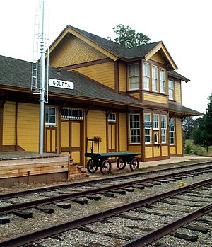
Goleta Depot
Distance: Approx. 1296 meters
Latitude and longitude: 34.44222222,-119.85277778
Goleta Depot is a train station building in Goleta, California constructed by the Southern Pacific Railroad in 1901, as part of the completion of the Coast Route linking Los Angeles and San Francisco. It is a Southern Pacific standard design Two Story Combination Depot No. 22.

UGG (brand)
Australian fashion company
Distance: Approx. 458 meters
Latitude and longitude: 34.4296,-119.86202
UGG is an American fashion company primarily known for its sheepskin boots, founded in 1978 by Brian Smith in California. UGG also sells apparel, accessories, and home textiles.

Direct Relief
Charitable organization
Distance: Approx. 1808 meters
Latitude and longitude: 34.43734,-119.8432121
Direct Relief (formerly known as Direct Relief International) is a nonprofit humanitarian organization whose mission is to improve the lives of people in poverty or emergency situations by providing the appropriate medical resources. The charity provides emergency medical assistance and disaster relief in the United States and internationally. Direct Relief does not accept government funding but instead relies on private, charitable contributions and donated medicine and supplies.

Goleta station
Railway station in Goleta, California, US
Distance: Approx. 1827 meters
Latitude and longitude: 34.4377,-119.8431
Goleta station is a passenger rail station in the city of Goleta, California. It is served by the Amtrak Pacific Surfliner; it is the northern terminal for three of those round trips. Trains terminating in Goleta are stored on a storage track adjacent to the station.

Caesar Uyesaka Stadium
Baseball stadium in Santa Barbara, California
Distance: Approx. 1909 meters
Latitude and longitude: 34.418609,-119.852536
Caesar Uyesaka Stadium is a baseball stadium in Santa Barbara, California. It is the home field of the UC Santa Barbara Gauchos baseball team as well as the Santa Barbara Foresters.
La Patera, California
Unincorporated community in California, United States
Distance: Approx. 1900 meters
Latitude and longitude: 34.4375,-119.84222222
La Patera (Spanish for "The Place of Ducks") was a historical locale in what is now the area of Goleta, California. Prior to European settlement, the area was inhabited by the Chumash, who had a settlement in the area named Saspilil. The Portolá expedition reached the area in August 1769 and gave it the name Laguna, but this was later changed to La Patera owing to the abundant ducks inhabiting the area's wetlands.
Weather in this IP's area
clear sky
21 Celsius
19 Celsius
20 Celsius
24 Celsius
1025 hPa
17 %
1025 hPa
1004 hPa
10000 meters

