Country:
 USA
USARegion:
City:
Latitude and Longitude:
Time Zone:
Postal Code:
IP information under different IP Channel
ip-api
Country
Region
City
ASN
Time Zone
ISP
Blacklist
Proxy
Latitude
Longitude
Postal
Route
IPinfo
Country
Region
City
ASN
Time Zone
ISP
Blacklist
Proxy
Latitude
Longitude
Postal
Route
MaxMind
Country
Region
City
ASN
Time Zone
ISP
Blacklist
Proxy
Latitude
Longitude
Postal
Route
Luminati
Country
USRegion
il
City
vandalia
ASN
Time Zone
America/Chicago
ISP
COGENT-174
Latitude
Longitude
Postal
db-ip
Country
Region
City
ASN
Time Zone
ISP
Blacklist
Proxy
Latitude
Longitude
Postal
Route
ipdata
Country
Region
City
ASN
Time Zone
ISP
Blacklist
Proxy
Latitude
Longitude
Postal
Route
Popular places and events near this IP address

Vandalia, Illinois
City in Illinois, United States
Distance: Approx. 3969 meters
Latitude and longitude: 38.97527778,-89.11166667
Vandalia is a city in and the county seat of Fayette County, Illinois, United States. At the 2020 Census, the population was 7,458. Vandalia is on the Kaskaskia River, and 60 miles (97 km) northeast of the St.
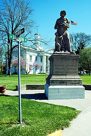
Vandalia State House State Historic Site
United States historic place
Distance: Approx. 2365 meters
Latitude and longitude: 38.96111111,-89.09388889
The Vandalia State House, built in 1836, is the fourth capitol building of the U.S. state of Illinois. It is also the oldest capitol building in Illinois to survive, as the first, second, and third capitol buildings have all disappeared. The brick Federal style state house has been operated by the state of Illinois as a monument of Illinois' pioneer years since 1933.

Little Brick House
Historic house in Illinois, United States
Distance: Approx. 3057 meters
Latitude and longitude: 38.96805556,-89.10194444
Little Brick House is a restored 1860s middle-class home in Vandalia, Illinois, located in Fayette County. The home is the only house in Vandalia to be listed on the National Register of Historic Places. It has been listed as such since 1973.

First Presbyterian Church (Vandalia, Illinois)
Historic church in Illinois, United States
Distance: Approx. 3057 meters
Latitude and longitude: 38.96805556,-89.10194444
The First Presbyterian Church is a museum and former Presbyterian church located at 301 W. Main St. in Vandalia, Illinois. The church was built in 1868 on the site of the first Protestant church in Illinois.

Bear Grove Township, Fayette County, Illinois
Township in Illinois, United States
Distance: Approx. 8134 meters
Latitude and longitude: 38.96055556,-89.19138889
Bear Grove Township is one of twenty townships in Fayette County, Illinois, USA. As of the 2020 census, its population was 553 and it contained 232 housing units. The township was originally known as Johnson Township.

Vandalia Township, Fayette County, Illinois
Township in Illinois, United States
Distance: Approx. 2020 meters
Latitude and longitude: 38.95555556,-89.08777778
Vandalia Township is one of twenty townships in Fayette County, Illinois, USA. As of the 2020 census, its population was 6,364 and it contained 3,069 housing units.
Bluff City, Fayette County, Illinois
Unincorporated community in Illinois, United States
Distance: Approx. 5392 meters
Latitude and longitude: 38.96388889,-89.04638889
Bluff City is an unincorporated community in Fayette County, Illinois, United States. This community is located two miles east of Vandalia on the historic road of U.S. Route 40.
Hagarstown, Illinois
Unincorporated community in Illinois, United States
Distance: Approx. 5838 meters
Latitude and longitude: 38.94333333,-89.16833333
Hagarstown is an unincorporated community in Fayette County, Illinois, United States. Hagarstown is 4.5 miles (7.2 km) southwest of Vandalia. Hagarstown has a post office with ZIP code 62247.
WPMB
Radio station in Vandalia, Illinois
Distance: Approx. 2685 meters
Latitude and longitude: 38.95777778,-89.12277778
WPMB 1500 AM is a radio station licensed to Vandalia, Illinois. The station broadcasts an adult contemporary format and is owned by Cromwell Radio Group, through licensee The Cromwell Group, Inc. of Illinois.
Vandalia Correctional Center
Distance: Approx. 7672 meters
Latitude and longitude: 39.009422,-89.096364
The Vandalia Correctional Institution is a minimum-security state prison for men located in Vandalia, Fayette County, Illinois, owned and operated by the Illinois Department of Corrections. The facility was first opened in 1921. In 2011 the prison watchdog group John Howard Association released a report highly critical of conditions at Vandalia.
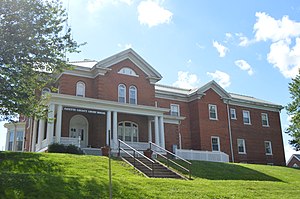
Fayette County Courthouse (Illinois)
Local government building in the United States
Distance: Approx. 2164 meters
Latitude and longitude: 38.96,-89.09944444
The Fayette County Courthouse is a government building in Vandalia, the county seat of Fayette County, Illinois, United States. Converted from a residence in the 1930s, it succeeded a former state capitol as the courthouse for Fayette County.
Vandalia Municipal Airport
Airport in Vandalia, IL, US
Distance: Approx. 8029 meters
Latitude and longitude: 38.99111111,-89.16722222
Vandalia Municipal Airport (IATA: VLA, ICAO: KVLA, FAA: VLA) is a civil, public use airport located 3 miles northwest of Vandalia, Illinois. The airport is publicly owned by the Vandalia Park District, which also manages the fixed-base operator (FBO) on the field.
Weather in this IP's area
clear sky
17 Celsius
16 Celsius
16 Celsius
18 Celsius
1031 hPa
42 %
1031 hPa
1014 hPa
10000 meters
4.11 m/s
5.35 m/s
161 degree
07:09:12
18:13:21