Country:
 Belgium
Region:
City:
Latitude and Longitude:
Time Zone:
Postal Code:
IP information under different IP Channel
ip-api
Country
Region
City
ASN
Time Zone
ISP
Blacklist
Proxy
Latitude
Longitude
Postal
Route
IPinfo
Country
Region
City
ASN
Time Zone
ISP
Blacklist
Proxy
Latitude
Longitude
Postal
Route
MaxMind
Country
Region
City
ASN
Time Zone
ISP
Blacklist
Proxy
Latitude
Longitude
Postal
Route
Luminati
Country
BEASN
Time Zone
Europe/Brussels
ISP
Google Switzerland GmbH
Latitude
Longitude
Postal
db-ip
Country
Region
City
ASN
Time Zone
ISP
Blacklist
Proxy
Latitude
Longitude
Postal
Route
ipdata
Country
Region
City
ASN
Time Zone
ISP
Blacklist
Proxy
Latitude
Longitude
Postal
Route
Popular places and events near this IP address

Etterbeek
Municipality of the Brussels-Capital Region, Belgium
Distance: Approx. 845 meters
Latitude and longitude: 50.83333333,4.38333333
Etterbeek (French: [etœʁbek, -bɛk] ; Dutch: [ˈɛtərˌbeːk] ) is one of the 19 municipalities of the Brussels-Capital Region, Belgium. Located in the eastern part of the region, it is bordered by the municipalities of Auderghem, the City of Brussels, Ixelles, Schaerbeek, Woluwe-Saint-Lambert and Woluwe-Saint-Pierre. In common with all of Brussels' municipalities, it is legally bilingual (French–Dutch).
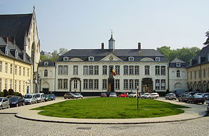
La Cambre Abbey
Former abbey in Brussels, Belgium
Distance: Approx. 898 meters
Latitude and longitude: 50.81888889,4.37416667
La Cambre Abbey (French: Abbaye de La Cambre, pronounced [a.be.i d(ə) la kɑ̃bʁ]) or Ter Kameren Abbey (Dutch: Abdij Ter Kameren) is a former Cistercian abbey in the City of Brussels, Belgium. It is located in the Maelbeek valley between the Bois de la Cambre/Ter Kamerenbos and the Ixelles Ponds. The abbey church is a Catholic parish of the Archdiocese of Mechelen–Brussels and home to a community of Norbertine canons, while other parts of the monastery house the headquarters of the Belgian National Geographic Institute (NGI) and La Cambre, a prestigious visual arts school.
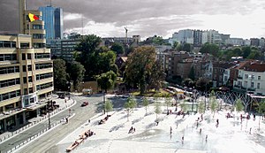
Place Eugène Flagey
Square in Brussels, Belgium
Distance: Approx. 596 meters
Latitude and longitude: 50.82777778,4.37222222
The Place Eugène Flagey (French: [plas øʒɛn flaʒɛ]) or Eugène Flageyplein (Dutch), usually shortened to the Place Flagey, or Flagey by locals, is a square in the Brussels municipality of Ixelles, Belgium. It bears the name of a former mayor of Ixelles, Eugène Flagey. With ten streets converging there, the Place Flagey is one of the best connected crossroads in the city, directly adjacent to the neighbouring Ixelles Ponds.

Ixelles Ponds
Park in Ixelles, Belgium
Distance: Approx. 552 meters
Latitude and longitude: 50.82361111,4.37333333
The Ixelles Ponds (French: Étangs d'Ixelles) or Elsene Ponds (Dutch: Vijvers van Elsene) are two freshwater ponds in the Brussels municipality of Ixelles, Belgium. The ponds we can see today are those spared by a 19th-century campaign of drying the wetlands of the Maelbeek valley between La Cambre Abbey and the Place Eugène Flagey/Eugène Flageyplein. The two long and narrow ponds, whose total lengths are approximately 700 metres (2,300 ft), and widths are approximately 50 metres (160 ft), are aligned on a roughly North–South axis and are separated by a narrow strip of land.

Etterbeek railway station
Railway station in Brussels, Belgium
Distance: Approx. 774 meters
Latitude and longitude: 50.82222222,4.38944444
Etterbeek railway station (French: Gare d'Etterbeek; Dutch: Station Etterbeek) is a railway station in Brussels, Belgium, operated by the National Railway Company of Belgium (NMBS/SNCB). The station is named after the municipality of Etterbeek, though it is located in neighbouring Ixelles, at the Couronne/Kroon crossroad on the Greater Ring. It first opened in 1880, and was, as of 2007, the 29th most used railway station in Belgium, with 5,565 passengers per day.
Institut Saint-André
Independent mixed primary and secondary school in Brussels, Belgium
Distance: Approx. 739 meters
Latitude and longitude: 50.819444,4.378542
Institut Saint-André is a French speaking Catholic free school ("ecole libre" - a subsidized state school in Belgium), situated in Ixelles, Brussels, Belgium. Commonly called "Saint-André" by students, it is composed of two campuses. The primary and "maternelle" (preschool) share a site on Chaussée de Boondael, while the secondary school is found on the nearby Avenue de l'Hippodrome.

Sterner's Studio
Historic Art Nouveau house in Brussels, Belgium
Distance: Approx. 692 meters
Latitude and longitude: 50.8244,4.3707
The House and Workshop of master glassmaker Sterner (French: Maison et Atelier du maître-verrier Sterner; Dutch: Atelier en Woning van meester glasmaker Sterner) in Brussels, Belgium, is the former town house and workshop of the master glassworker Clas Grüner Sterner. It was designed by the architect Ernest Delune, and built between 1893 and 1902, in Art Nouveau style. The house is located at 6, rue du Lac/Meerstraat in the municipality of Ixelles, not far from the Ixelles Ponds.

Germoir railway station
Railway station in Brussels, Belgium
Distance: Approx. 516 meters
Latitude and longitude: 50.83055556,4.37888889
Germoir railway station (French: Gare de Germoir) or Mouterij railway station (Dutch: Station Mouterij) is a railway station in the municipality of Ixelles in Brussels, Belgium. The station opened on 14 December 2015 on line 161. The train services are operated by the National Railway Company of Belgium (NMBS/SNCB).

Museum of Ixelles
Art museum in Brussels, Belgium
Distance: Approx. 845 meters
Latitude and longitude: 50.83166667,4.37222222
The Museum of Ixelles (French: Musée d'Ixelles; Dutch: Museum van Elsene), also called the (Municipal) Museum of Fine Arts of Ixelles (French: Musée (communal) des Beaux-Arts d'Ixelles; Dutch: (Gemeentelijk) Museum voor Schone Kunsten van Elsene), is a municipal art museum in Brussels, Belgium, focusing on Belgian art from the 19th and 20th centuries. The museum is located at 71, rue Jean Van Volsem/Jean Van Volsemstraat in Ixelles. It is served by the bus stops Musée d'Ixelles/Museum van Elsene (on line 71) and Malibran (on lines 38 and 60).

Hôtel Max Hallet
Historic Art Nouveau house in Brussels, Belgium
Distance: Approx. 847 meters
Latitude and longitude: 50.82238889,4.36961111
The Hôtel Max Hallet (French: Hôtel Max Hallet, Dutch: Hotel Max Hallet) is a historic town house in Brussels, Belgium. It was designed by Victor Horta, and built between 1903 and 1906, in Art Nouveau style. It is located at 346, avenue Louise/Louizalaan, not far from the Hôtel Solvay, another remarkable Art Nouveau building by Horta.

Sciensano
Belgian national institute
Distance: Approx. 216 meters
Latitude and longitude: 50.824308,4.381724
Sciensano is a research institute and the national public health institute of Belgium. It is a so-called federal scientific institution that operates under the authority of the federal minister of Public Health and the federal minister of Agriculture of Belgium. Sciensano's core business is scientific research in the fields of public health, animal health and food safety.

Flagey Building
Art Deco building, now a cultural centre, in Brussels, Belgium
Distance: Approx. 528 meters
Latitude and longitude: 50.82666667,4.37277778
The Flagey Building (French: Bâtiment Flagey; Dutch: Flageygebouw), also known as the Radio House (French: Maison de la Radio; Dutch: Radiohuis), is a building located in Ixelles, a municipality of Brussels, Belgium, housing the Flagey cultural centre. It is located on the south-western corner of Place Eugène Flagey/Eugène Flageyplein, with its main entrance on the Place Sainte-Croix/Heilig-Kruisplein. The building, parts of which are listed, was designed by the architect Joseph Diongre and completed in 1938 in Streamline Moderne, an international style of Art Deco.
Weather in this IP's area
light rain
11 Celsius
11 Celsius
10 Celsius
13 Celsius
1011 hPa
90 %
1011 hPa
1001 hPa
10000 meters
3.09 m/s
120 degree
08:07:24
18:48:12