Country:
Region:
City:
Latitude and Longitude:
Time Zone:
Postal Code:
IP information under different IP Channel
ip-api
Country
Region
City
ASN
Time Zone
ISP
Blacklist
Proxy
Latitude
Longitude
Postal
Route
Luminati
Country
Region
ny
City
newyork
ASN
Time Zone
America/New_York
ISP
PILOT
Latitude
Longitude
Postal
IPinfo
Country
Region
City
ASN
Time Zone
ISP
Blacklist
Proxy
Latitude
Longitude
Postal
Route
db-ip
Country
Region
City
ASN
Time Zone
ISP
Blacklist
Proxy
Latitude
Longitude
Postal
Route
ipdata
Country
Region
City
ASN
Time Zone
ISP
Blacklist
Proxy
Latitude
Longitude
Postal
Route
Popular places and events near this IP address

E-Trade
American financial services company
Distance: Approx. 33 meters
Latitude and longitude: 40.76,-73.981
E*TRADE from Morgan Stanley, a subsidiary of Morgan Stanley, offers an electronic trading platform to trade financial assets.

Carnegie Corporation of New York
American philanthropic fund
Distance: Approx. 91 meters
Latitude and longitude: 40.76,-73.98
The Carnegie Corporation of New York is a philanthropic fund established by Andrew Carnegie in 1911 to support education programs across the United States, and later the world. Since its founding, the Carnegie Corporation has endowed or otherwise helped establish institutions including the United States National Research Council, Harvard University's Davis Center for Russian and Eurasian Studies (formerly known as the Russian Research Center), the Carnegie libraries, the University of Chicago Graduate Library School, and the Children's Television Workshop (now Sesame Workshop). It also has funded the Carnegie Endowment for International Peace (CEIP), the Carnegie Foundation for the Advancement of Teaching (CFAT), and the Carnegie Institution for Science (CIS).
Toots Shor's Restaurant
Restaurant in New York, United States
Distance: Approx. 135 meters
Latitude and longitude: 40.76083333,-73.98044444
Toots Shor's Restaurant was a restaurant and lounge owned and operated by Bernard "Toots" Shor at 51 West 51st Street in Manhattan during the 1940s and 1950s. It was known for its oversized circular bar. It was frequented by celebrities, and together with the 21 Club, the Stork Club, Delmonico's and El Morocco was one of the places to see and be seen.

1271 Avenue of the Americas
Office skyscraper in Manhattan, New York
Distance: Approx. 96 meters
Latitude and longitude: 40.76055556,-73.98111111
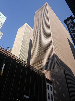
1271 Avenue of the Americas (formerly known as the Time & Life Building) is a 48-story skyscraper on Sixth Avenue (Avenue of the Americas), between 50th and 51st streets, in the Midtown Manhattan neighborhood of New York City. Designed by architect Wallace Harrison of Harrison, Abramovitz, and Harris, the building was developed between 1956 and 1960 as part of Rockefeller Center. The building's eight-story base partially wraps around its 48-story main shaft.
Center Theatre (New York City)
Former theatre in Manhattan, New York
Distance: Approx. 116 meters
Latitude and longitude: 40.7587,-73.9806
The Center Theatre was a theater located at 1230 Sixth Avenue, the southeast corner of West 49th Street in Rockefeller Center in New York City. Seating 3,500, it was originally designed as a movie palace in 1932 and later achieved fame as a showcase for live musical ice-skating spectacles.

47th–50th Streets–Rockefeller Center station
New York City Subway station in Manhattan
Distance: Approx. 126 meters
Latitude and longitude: 40.758603,-73.981376
The 47th–50th Streets–Rockefeller Center station (formerly 47th Street–50th Street–Rockefeller Center) is an express station on the IND Sixth Avenue Line of the New York City Subway. It is located along Sixth Avenue (Avenue of the Americas) between 47th and 50th Streets, on the west side of Rockefeller Center. The station is served by the D and F trains at all times, the B and M trains on weekdays, and the <F> train during rush hours in the peak direction.

1251 Avenue of the Americas
Office skyscraper in Manhattan, New York
Distance: Approx. 47 meters
Latitude and longitude: 40.76,-73.98138889
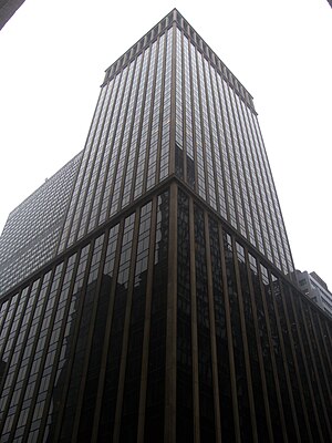
1251 Avenue of the Americas (formerly known as the Exxon Building) is a skyscraper on Sixth Avenue (also known as Avenue of the Americas), between 49th and 50th Streets, in the Midtown Manhattan neighborhood of New York City. It is owned by Mitsui Fudosan. The structure is built in the international style and looks like a simple cuboid devoid of any ornamentation.

1221 Avenue of the Americas
Office skyscraper in Manhattan, New York
Distance: Approx. 82 meters
Latitude and longitude: 40.75916667,-73.98166667
1221 Avenue of the Americas (formerly also known as the McGraw-Hill Building) is an international-style skyscraper at 1221 Sixth Avenue (also known as the Avenue of the Americas) in Midtown Manhattan, New York City. The 51-floor structure has a seven-story base and a simple, cuboid massing. The facade has no decoration and consists of red granite piers alternating with glass stripes to underline the tower's verticality.
50th Street station (IRT Sixth Avenue Line)
Former Manhattan Railway elevated station (closed 1938)
Distance: Approx. 51 meters
Latitude and longitude: 40.759875,-73.98043611
The 50th Street station was a station on the demolished IRT Sixth Avenue Line in Manhattan, New York City. It had two tracks and two side platforms. It was served by trains from the IRT Sixth Avenue Line and opened on June 5, 1878.
Playhouse Theatre (New York City)
Former theatre in Manhattan, New York
Distance: Approx. 130 meters
Latitude and longitude: 40.75944444,-73.9825
The Playhouse Theatre was a Broadway theater at 137 West 48th Street in midtown Manhattan, New York City. Charles A. Rich was the architect. It was built in 1911 for producer William A. Brady who also owned the nearby 48th Street Theatre.
Belmont Theatre
Former theater in New York City
Distance: Approx. 99 meters
Latitude and longitude: 40.75916667,-73.98194444
The Belmont Theatre, also known during its existence as the Norworth Theatre and the Theatre Parisien, was a Broadway theatre located at 125 W. 48th St., New York, New York. It was designed by architect Eugene De Rosa. It was active as a Broadway theatre from 1918 through 1933.

Oceana (restaurant)
Restaurant in New York City
Distance: Approx. 110 meters
Latitude and longitude: 40.75977778,-73.98230556
Oceana is a restaurant in New York City. The restaurant opened in 2009 and serves seafood.
Weather in this IP's area
clear sky
18 Celsius
17 Celsius
16 Celsius
19 Celsius
1012 hPa
37 %
1012 hPa
1009 hPa
10000 meters
6.17 m/s
10.29 m/s
270 degree
06:35:10
16:44:19