Country:
 USA
USARegion:
City:
Latitude and Longitude:
Time Zone:
Postal Code:
IP information under different IP Channel
ip-api
Country
Region
City
ASN
Time Zone
ISP
Blacklist
Proxy
Latitude
Longitude
Postal
Route
IPinfo
Country
Region
City
ASN
Time Zone
ISP
Blacklist
Proxy
Latitude
Longitude
Postal
Route
MaxMind
Country
Region
City
ASN
Time Zone
ISP
Blacklist
Proxy
Latitude
Longitude
Postal
Route
Luminati
Country
USRegion
ga
City
lithiasprings
ASN
Time Zone
America/New_York
ISP
Akamai International B.V.
Latitude
Longitude
Postal
db-ip
Country
Region
City
ASN
Time Zone
ISP
Blacklist
Proxy
Latitude
Longitude
Postal
Route
ipdata
Country
Region
City
ASN
Time Zone
ISP
Blacklist
Proxy
Latitude
Longitude
Postal
Route
Popular places and events near this IP address

Austell, Georgia
City in Georgia, United States
Distance: Approx. 5691 meters
Latitude and longitude: 33.81583333,-84.63611111
Austell is a city in Cobb and Douglas counties in the U.S. state of Georgia. It is part of the Atlanta metropolitan area. As of the 2020 census, the city had a population of 7,713.

Douglasville, Georgia
City in Georgia, United States
Distance: Approx. 7264 meters
Latitude and longitude: 33.74972222,-84.72305556
The city of Douglasville is the county seat of and largest city in Douglas County, Georgia, United States. As of the 2020 census, the city had a population of 34,650, up from 30,961 in 2010 and 20,065 in 2000. Douglasville is located approximately 20 miles (32 km) west of Atlanta and is part of the Atlanta metro area.
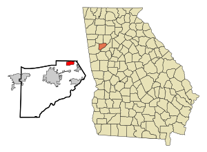
Lithia Springs, Georgia
Place in Georgia, United States
Distance: Approx. 3633 meters
Latitude and longitude: 33.79722222,-84.65611111
Lithia Springs () is an unincorporated community and census-designated place, formerly incorporated as a city, located in northeastern Douglas County, Georgia, United States. As of the 2020 census, the community had a population of 16,644. The area is named for its historic lithia mineral water springs.
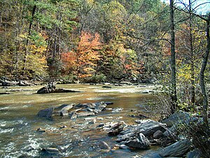
Sweetwater Creek (Chattahoochee River tributary)
River in Georgia, United States
Distance: Approx. 6566 meters
Latitude and longitude: 33.71761,-84.60549
Sweetwater Creek is a 45.6-mile-long (73.4 km) stream in the U.S. state of Georgia, west of Atlanta. It begins in southwestern Paulding County, flowing generally eastward into southwestern Cobb County, then turning south into eastern Douglas County. It is a tributary of the Chattahoochee River, and near its end it is the centerpiece of Sweetwater Creek State Park.

Sweetwater Creek State Park
State park in Georgia, United States
Distance: Approx. 1278 meters
Latitude and longitude: 33.75833333,-84.63611111
Sweetwater Creek State Park is a 2,549 acres (10.32 km2) Georgia state park in east Douglas County, 15 miles (24 km) from downtown Atlanta. The park is named after Sweetwater Creek which runs through it. Cherokee people were forcibly removed from the area and it eventually became home to the New Manchester Manufacturing Company and mill town of New Manchester.
Pebblebrook High School
Public high school in Mableton, Georgia, United States
Distance: Approx. 7509 meters
Latitude and longitude: 33.806,-84.582
Pebblebrook High School is a high school in the Cobb County School District in Mableton, Georgia, United States. The school opened in 1963, serving grades 9-12. Pebblebrook houses the Cobb County Center for Excellence in the Performing Arts, the first magnet program offered within the Cobb County School District.

South Cobb High School
Public high school in Austell, Georgia
Distance: Approx. 8545 meters
Latitude and longitude: 33.8355,-84.609
South Cobb High School is an American public high school in Austell, Georgia. Founded in 1952, it is part of the Cobb County School District. Clint Terza succeeded Ashley Hosey as principal in 2016.
Colonial Hills Christian School
Private school in Lithia Springs, Georgia, United States
Distance: Approx. 1910 meters
Latitude and longitude: 33.78111111,-84.63833333
Colonial Hills Christian School was a private Christian school located in East Point and Lithia Springs, Georgia, United States. The school was founded in 1959 and was affiliated with the Colonial Hills Baptist Church.
WellStar Douglas Hospital
Hospital in Georgia, United States
Distance: Approx. 8372 meters
Latitude and longitude: 33.7391,-84.7316
Wellstar Douglas Hospital (formerly WellStar Douglas Hospital), originally known as Douglas Hospital and Douglas General Hospital, is a medical facility in Douglasville, Georgia. It opened in 1948. The original Douglas Hospital opened with 15 patient beds.
Clarkdale, Georgia
Unincorporated community in Georgia, U.S.
Distance: Approx. 7278 meters
Latitude and longitude: 33.83083333,-84.64972222
Clarkdale is an unincorporated community west-northwest of Atlanta, Georgia, in southwestern Cobb County. It has a post office with ZIP Code 30111 and is the hometown of novelty and country singer Ray Stevens. The population in 2020 was 23,401.
Lithia Springs High School
Public high school in Lithia Springs, Georgia, United States
Distance: Approx. 1971 meters
Latitude and longitude: 33.7542,-84.6633
Lithia Springs High School is a public high school located on East County Line Road, in Lithia Springs, Georgia, United States. It is also known as Lithia Springs Comprehensive High School. It was the second high school to open in the Douglas County School District.

Beulah Grove Lodge No. 372, Free and Accepted York Masons
Historic building in Georgia, United States
Distance: Approx. 6630 meters
Latitude and longitude: 33.70666667,-84.65805556
The Beulah Grove Lodge No. 372, Free and Accepted York Masons, also known as Pleasant Grove School and Pleasant Grove Colored School, in Douglas County, Georgia near Douglasville, Georgia, was built in 1910. It was listed on the National Register of Historic Places in 2010.
Weather in this IP's area
clear sky
20 Celsius
19 Celsius
18 Celsius
21 Celsius
1028 hPa
43 %
1028 hPa
996 hPa
10000 meters
3.09 m/s
100 degree
07:46:04
19:00:52