Country:
 USA
USARegion:
City:
Latitude and Longitude:
Time Zone:
Postal Code:
IP information under different IP Channel
ip-api
Country
Region
City
ASN
Time Zone
ISP
Blacklist
Proxy
Latitude
Longitude
Postal
Route
IPinfo
Country
Region
City
ASN
Time Zone
ISP
Blacklist
Proxy
Latitude
Longitude
Postal
Route
MaxMind
Country
Region
City
ASN
Time Zone
ISP
Blacklist
Proxy
Latitude
Longitude
Postal
Route
Luminati
Country
USRegion
pa
City
pittsburgh
ASN
Time Zone
America/New_York
ISP
Akamai International B.V.
Latitude
Longitude
Postal
db-ip
Country
Region
City
ASN
Time Zone
ISP
Blacklist
Proxy
Latitude
Longitude
Postal
Route
ipdata
Country
Region
City
ASN
Time Zone
ISP
Blacklist
Proxy
Latitude
Longitude
Postal
Route
Popular places and events near this IP address

Braddock Expedition
Military expedition during French and Indian War
Distance: Approx. 72 meters
Latitude and longitude: 40.43333333,-80
The Braddock Expedition, also known as Braddock's Campaign or Braddock's Defeat, was a British military expedition which attempted to capture Fort Duquesne from the French in 1755 during the French and Indian War. The expedition, named after its commander General Edward Braddock, was defeated at the Battle of the Monongahela on July 9 and forced to retreat; Braddock was killed in action along with more than 500 of his troops. It ultimatley proved to be a major setback for the British in the early stages of the war; John Mack Faragher claimed it was one of the most disastrous defeats suffered by British forces in the 18th century.

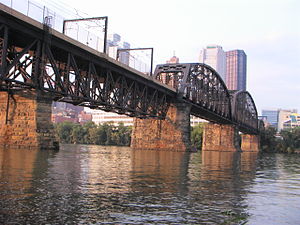
Smithfield Street Bridge
Bridge over the Monongahela River in Pittsburgh, Pennsylvania
Distance: Approx. 240 meters
Latitude and longitude: 40.43472222,-80.00222222
The Smithfield Street Bridge is a lenticular truss bridge crossing the Monongahela River in Pittsburgh, Pennsylvania, USA. The bridge was designed by Gustav Lindenthal, the engineer who later designed the Hell Gate Bridge in New York City. The Smithfield Street Bridge was built between 1881 and 1883, opening for traffic on March 19, 1883. It was widened in 1889 and widened again in 1911.

Liberty Bridge (Pittsburgh)
Bridge in Pittsburgh, Pennsylvania
Distance: Approx. 275 meters
Latitude and longitude: 40.4328,-79.9967
The Liberty Bridge, which was completed in 1928, connects downtown Pittsburgh, Pennsylvania, to the Liberty Tunnels and the South Hills neighborhoods beyond. It crosses the Monongahela River and intersects Interstate 579 (the Crosstown Boulevard) at its northern terminus. It was designed by George S. Richardson and cost $3,456,000 to build.
Panhandle Bridge
Bridge over the Monongahela River in Pittsburgh, Pennsylvania, U.S.
Distance: Approx. 158 meters
Latitude and longitude: 40.43308889,-79.99807222
The Panhandle Bridge (officially the Monongahela River Bridge) carries the three lines of the Port Authority Light Rail Network across the Monongahela River in Pittsburgh, Pennsylvania. The name comes from Pennsylvania Railroad subsidiary Pittsburgh, Cincinnati, Chicago and St. Louis Railroad, also known as the Panhandle Route, which operated over the bridge.
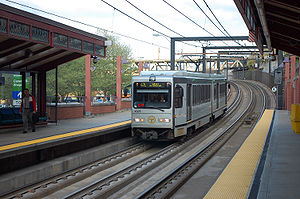
Station Square station
Distance: Approx. 398 meters
Latitude and longitude: 40.4317,-80.0033
Station Square station is an intermodal transit station in the South Shore neighborhood of Pittsburgh, Pennsylvania, located at the Station Square shopping and entertainment complex. It is served by the Red Line, Blue Line, and Silver Line of the Pittsburgh Light Rail network, and is the northern terminus of the South Busway. The station is near the Monongahela Incline and the Gateway Clipper Fleet.

Hartley-Rose Belting Company Building
United States historic place
Distance: Approx. 339 meters
Latitude and longitude: 40.43694444,-79.99972222
The Hartley-Rose Belting Company Building in Pittsburgh, Pennsylvania, is a building from 1906. It was listed on the National Register of Historic Places in 1983.

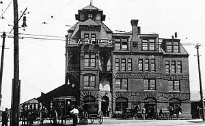
Pittsburgh & Lake Erie Railroad Station
Distance: Approx. 365 meters
Latitude and longitude: 40.43361111,-80.00388889
The Pittsburgh & Lake Erie Railroad Station, now Landry's Grand Concourse restaurant in Station Square Plaza in Pittsburgh, Pennsylvania, is an historic building that was erected in 1898. It was listed on the National Register of Historic Places in 1974.

Grant Street Station
Distance: Approx. 269 meters
Latitude and longitude: 40.43611111,-79.99833333
Grant Street Station, also known as the B&O Pittsburgh Terminal, was a passenger rail station on Grant Street downtown Pittsburgh, Pennsylvania. The Baltimore and Ohio Railroad (B&O) announced plans for it on May 3, 1955, after selling the original B&O Station bordering the Monongahela River to the state for construction of Interstate 376. It opened in 1957 to serve commuter rail traffic; all intercity traffic continued to use the Pittsburgh and Lake Erie Railroad's (P&LE) station (now called Station Square).

Chinatown, Pittsburgh
Sub-neighborhood in Allegheny County, Pennsylvania, United States
Distance: Approx. 378 meters
Latitude and longitude: 40.4369,-79.9975
The U.S. city of Pittsburgh, Pennsylvania, was home to a "small, but busy" Chinatown, located at the intersection of Grant Street and Boulevard of the Allies in Downtown Pittsburgh where only one Chinese restaurant remains. The On Leong Society was located there. According to the article, "...
Baltimore and Ohio Station (Pittsburgh)
Distance: Approx. 283 meters
Latitude and longitude: 40.4363,-80.0007
B&O Railroad Depot was one of several railroad stations in the city of Pittsburgh, Pennsylvania during the late 19th and early 20th century. The station was built in 1887, 16 years after the B&O Railroad opened its first railroad line into Pittsburgh. The station was built next to the Monongahela River.

Salvation Army Building (Pittsburgh, Pennsylvania)
Historic building in Pittsburgh, Pennsylvania
Distance: Approx. 405 meters
Latitude and longitude: 40.4375,-79.99888889
The Salvation Army Building is a historic building located at 425–435 Boulevard of the Allies in Pittsburgh, Pennsylvania. The building was constructed in 1924 with a large eastern addition in 1930 in the Late Gothic Revival style. The multi-purpose building originally housed the headquarters, residential and recreational functions for the Salvation Army of Western Pennsylvania from 1924 until 2008.

Jones & Laughlin Headquarters Building
United States historic place
Distance: Approx. 405 meters
Latitude and longitude: 40.43682,-79.99675
The former Jones and Laughlin building is located at 200 Ross Street in the Downtown neighborhood of Pittsburgh, Pennsylvania. Built in 1907 in the Jacobean Revival architectural style, the building served as the headquarters of the Jones and Laughlin Steel Company from its construction until 1952 and currently holds offices for various governmental agencies in the City of Pittsburgh. It was designated a City of Pittsburgh Historic Landmark in 2020 and was listed on the National Register of Historic Places in 2021.
Weather in this IP's area
clear sky
11 Celsius
11 Celsius
10 Celsius
12 Celsius
1018 hPa
85 %
1018 hPa
992 hPa
10000 meters
0.45 m/s
0.45 m/s
202 degree
7 %
06:53:41
19:42:23