Country:
 Israel
Region:
City:
Latitude and Longitude:
Time Zone:
Postal Code:
IP information under different IP Channel
ip-api
Country
Region
City
ASN
Time Zone
ISP
Blacklist
Proxy
Latitude
Longitude
Postal
Route
IPinfo
Country
Region
City
ASN
Time Zone
ISP
Blacklist
Proxy
Latitude
Longitude
Postal
Route
MaxMind
Country
Region
City
ASN
Time Zone
ISP
Blacklist
Proxy
Latitude
Longitude
Postal
Route
Luminati
Country
ILRegion
ha
City
haifa
ASN
Time Zone
Asia/Jerusalem
ISP
Cellcom Fixed Line Communication L.P
Latitude
Longitude
Postal
db-ip
Country
Region
City
ASN
Time Zone
ISP
Blacklist
Proxy
Latitude
Longitude
Postal
Route
ipdata
Country
Region
City
ASN
Time Zone
ISP
Blacklist
Proxy
Latitude
Longitude
Postal
Route
Popular places and events near this IP address

Universal House of Justice
Elected institution governing the worldwide Baháʼí community
Distance: Approx. 699 meters
Latitude and longitude: 32.81166667,34.9875
The Universal House of Justice (Persian: بیتالعدل اعظم) is the nine-member supreme ruling body of the Baháʼí Faith. It was envisioned by Baháʼu'lláh, the founder of the Baháʼí Faith, as an institution that could legislate on issues not already addressed in the Baháʼí writings, providing flexibility for the Baháʼí Faith to adapt to changing conditions. It was first elected in 1963, and subsequently every five years, by delegates consisting of the members of Baháʼí National Spiritual Assemblies throughout the world.

Battle of Haifa (1948)
Battle of the Arab-Israeli War
Distance: Approx. 646 meters
Latitude and longitude: 32.81551389,34.97521389
The Battle of Haifa, called by the Jewish forces Operation Bi'ur Hametz (Hebrew: מבצע ביעור חמץ "Passover Cleaning"), was a Haganah operation carried out on 21–22 April 1948 and a major event in the final stages of the civil war in Palestine, leading up to the 1948 Arab-Israeli War. The objective of the operation was the capture of the Arab neighborhoods of Haifa. The operation formed part of the 1948 Palestinian expulsion and flight, with approximately 15,000 Arab residents being displaced between April 21–22, and with only 4,000 remaining in the city by mid-May from a pre-conflict population of approximately 65,000.
Rúhíyyih Khánum
Wife of Baháʼí leader Shoghi Effendi
Distance: Approx. 485 meters
Latitude and longitude: 32.81444444,34.98694444
Amatu'l-Bahá Rúhíyyih Khánum (born Mary Sutherland Maxwell; 8 August 1910 – 19 January 2000) was an American-born Canadian Hand of the Cause of the Baháʼí Faith. She was the wife of the Ottoman-born Iranian religious figure Shoghi Effendi, who succeeded his grandfather ʻAbdu'l-Bahá to become the Guardian of the Baháʼí Faith between 1921 and 1957. Appointed as a Hand of the Cause in 1952, her primary responsibility was to expand and protect the global Baháʼí community.
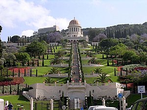
Terraces (Baháʼí)
Garden terraces around the Shrine of the Báb on Mount Carmel in Haifa, Israel
Distance: Approx. 485 meters
Latitude and longitude: 32.81444444,34.98694444
The Baháʼí Terraces, or the Hanging Gardens of Haifa, are garden terraces on Mount Carmel in Haifa, and one of the most popular tourist destinations in Israel. Completed in 2001, there are 19 terraces and more than 1,500 steps ascending the mountain. The central terrace has the Shrine of the Báb, one of the main religious sites of the Baháʼí Faith.

Baháʼí World Centre buildings
Buildings and gardens that are part of the Baháʼí World Centre in Haifa and Acre, Israel
Distance: Approx. 581 meters
Latitude and longitude: 32.81222222,34.98638889
The Baháʼí World Centre buildings are buildings that are part of the Baháʼí World Centre in Israel. The Baháʼí World Centre buildings include both the Baháʼí holy places used for pilgrimage and the international administrative bodies of the Baháʼí Faith; they comprise more than 20 different administrative offices, pilgrim buildings, libraries, archives, historical residences, and shrines. These structures are all set amidst more than 30 different gardens or individual terraces.
Ramat HaTishbi
Distance: Approx. 599 meters
Latitude and longitude: 32.81413056,34.97609167
Ramat HaTishbi (Hebrew: רמת התשבי) is a relatively small neighbourhood in Haifa, Israel, located on the western slopes of Mount Carmel, adjacent to the French Carmel neighbourhood. It includes the streets of Hatishbi, Beit El, Shounamit, and Ovadia.
Shrine of ʻAbdu'l-Bahá
Tomb under construction near Acre, Israel
Distance: Approx. 518 meters
Latitude and longitude: 32.81461111,34.98738889
The Shrine of ʻAbdu'l-Bahá is the location in Israel wherein the remains of ʻAbdu'l-Bahá, one of the central figures of the Baháʼí Faith, will be interred. Since his death in 1921, ʻAbdu'l-Bahá's remains have been located beneath one of the rooms of the Shrine of the Báb in Haifa, Israel.

Baháʼí World Centre
Spiritual and administrative centre of the Baháʼí Faith, in and around Haifa, Israel
Distance: Approx. 485 meters
Latitude and longitude: 32.81444444,34.98694444
The Baháʼí World Centre is the name given to the spiritual and administrative centre of the Baháʼí Faith, representing sites in or near the cities of Acre and Haifa, Israel. Much of the international governance and coordination of the Baháʼí Faith occurs at the Baháʼí World Centre, including global teaching plans and study and translation of the Baháʼí holy writings. The Universal House of Justice, representing the supreme governing body of the Baháʼí Faith, resides in Haifa.

Battle of Haifa (1918)
Battle of World War I
Distance: Approx. 137 meters
Latitude and longitude: 32.81666667,34.98333333
The Battle of Haifa was fought on 23 September 1918 towards the end of the Battle of Sharon which together with the Battle of Nablus formed the set piece Battle of Megiddo fought between 19 and 25 September during the last months of the Sinai and Palestine Campaign of the First World War. During the Battle of Haifa, the Indian 15th (Imperial Service) Cavalry Brigade, 5th Cavalry Division and part of the Desert Mounted Corps attacked rearguard forces of the Ottoman Empire that resulted in the capture of the towns of Haifa and Acre. This attack took place at the north western edge of the Esdraelon Plain (also known as the Jezreel Valley and the plain of Armageddon), 40–50 miles (64–80 km) from Sharon.
Timeline of Haifa
Distance: Approx. 137 meters
Latitude and longitude: 32.816667,34.983333
The following is a timeline of the history of the city of Haifa, Israel.

Monastery of Our Lady of Mount Carmel
Distance: Approx. 382 meters
Latitude and longitude: 32.8179,34.9787
The Monastery of Our Lady of Mount Carmel is a Catholic Christian monastery for Carmelite nuns that sits on the slope of Mount Carmel, in Haifa, Israel. The monastery is dedicated to Our Lady of Mount Carmel. The community of Our Lady of Mount Carmel was founded in 1892 by a group of French Carmelite nuns.
Abbas, Haifa
Neighbourhood in Haifa, Israel
Distance: Approx. 232 meters
Latitude and longitude: 32.81666667,34.98444444
Abbas (Hebrew: עבאס) is a neighborhood in the city of Haifa in northern Israel. It is located in the administrative region of Hadar, on the edge of the Mount Carmel. neighborhoods such as German Colony, Wadi Nisnas and Abbas, are largely Arab Christian.
Weather in this IP's area
few clouds
31 Celsius
35 Celsius
31 Celsius
33 Celsius
1010 hPa
60 %
1010 hPa
995 hPa
10000 meters
5.14 m/s
260 degree
20 %
06:19:29
18:56:16