Country:
 USA
USARegion:
City:
Latitude and Longitude:
Time Zone:
Postal Code:
IP information under different IP Channel
ip-api
Country
Region
City
ASN
Time Zone
ISP
Blacklist
Proxy
Latitude
Longitude
Postal
Route
IPinfo
Country
Region
City
ASN
Time Zone
ISP
Blacklist
Proxy
Latitude
Longitude
Postal
Route
MaxMind
Country
Region
City
ASN
Time Zone
ISP
Blacklist
Proxy
Latitude
Longitude
Postal
Route
Luminati
Country
USRegion
ma
City
billerica
ASN
Time Zone
America/New_York
ISP
Akamai International B.V.
Latitude
Longitude
Postal
db-ip
Country
Region
City
ASN
Time Zone
ISP
Blacklist
Proxy
Latitude
Longitude
Postal
Route
ipdata
Country
Region
City
ASN
Time Zone
ISP
Blacklist
Proxy
Latitude
Longitude
Postal
Route
Popular places and events near this IP address

Billerica, Massachusetts
Town in Massachusetts, United States
Distance: Approx. 756 meters
Latitude and longitude: 42.55833333,-71.26944444
Billerica ( ) is a town in Middlesex County, Massachusetts, United States. The population was 42,119 according to the 2020 census. It takes its name from the town of Billericay in Essex, England.
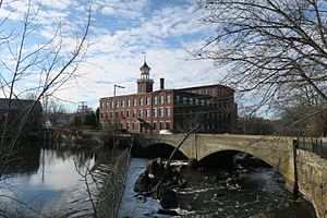
North Billerica, Massachusetts
Village of the town of Billerica, Massachusetts, US
Distance: Approx. 3064 meters
Latitude and longitude: 42.58333333,-71.28444444
North Billerica is an unincorporated village of the town of Billerica, Massachusetts, United States, one of the nine sections (hamlets) that make up the Town of Billerica. It is the home to Faulkner and Talbot mills and the North Billerica Train Depot. The Middlesex Canal was built through the village in 1783 and the Boston and Lowell Railroad was put through in the 1840s.
Merck Millipore
Deprecated brand name used by Merck Group after Millipore acquisition
Distance: Approx. 2023 meters
Latitude and longitude: 42.53841667,-71.28327778
Merck Millipore was the brand used by Merck Group's (not US-based Merck & Co.) global life science business until 2015 when the company re-branded. It was formed when Merck acquired the Millipore Corporation in 2010. Merck is a supplier to the life science industry.

Billerica Memorial High School
Public school in the United States
Distance: Approx. 691 meters
Latitude and longitude: 42.56111111,-71.27305556
Billerica Memorial High School (BMHS), formerly Howe High School, is a public secondary school in the town of Billerica, Massachusetts. It is the only high school under the purview of the Billerica Public Schools district, and serves approximately 1,600 students between grades 8 and 12. The school is supervised by a district superintendent who reports to an elected school committee for the town.

Sabbath Day House (Billerica, Massachusetts)
Historic house in Massachusetts, United States
Distance: Approx. 1018 meters
Latitude and longitude: 42.56083333,-71.2675
The Sabbath Day House is an historic house located in Billerica, Massachusetts. The main block of the 1.5-story wood-frame house was built in the mid-1760s to provide a place for parishioners to warm themselves in between the morning and afternoon services at the adjacent Congregational Church. The house was in that time maintained by a caretaker, and came into private ownership in 1818, when it was no longer needed for its original purpose.

Dutton–Holden Homestead
Historic house in Massachusetts, United States
Distance: Approx. 1535 meters
Latitude and longitude: 42.56555556,-71.26444444
The Dutton–Holden Homestead is a historic house at 28 Pond Street in Billerica, Massachusetts. The main block of this 2+1⁄2-story timber-frame house is believed to have been built between 1750 and 1770, based on structural analysis; tradition places its construction earlier, by Jonathan Dutton c. 1720.

Deacon Samuel Hill House
Historic house in Massachusetts, United States
Distance: Approx. 3041 meters
Latitude and longitude: 42.53611111,-71.30333333
The Deacon Samuel Hill House is a historic First Period house in Billerica, Massachusetts. The 2+1⁄2-story timber-frame house is estimated to have been built around 1725, based on analysis of its construction techniques. It was probably built by Deacon Samuel Hill, who inherited the property where it stood from Ralph Hill, an early settler of the area.
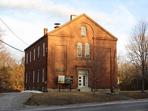
Howe School
United States historic place
Distance: Approx. 958 meters
Latitude and longitude: 42.5621,-71.2697
The Howe School is a historic school building at 390 Boston Road in Billerica, Massachusetts. This three story brick building was built in 1852 with funding from a bequest by Zadok Howe, and served the town as a secondary educational institution for 100 years. Designed by Daniel G. Bean of Lowell, the building including an innovative ventilation system for bringing warm and fresh air into the classrooms.
Shops at Billerica
Shopping mall in Billerica, Massachusetts
Distance: Approx. 1272 meters
Latitude and longitude: 42.55630556,-71.26269444
The Shops at Billerica (formerly known as Billerica Mall) is a strip mall and former enclosed shopping mall located in Billerica, Massachusetts. It was built as part of a series of malls including the Woburn Mall, and the Mystic Mall. Anchor stores include Burlington and Big Lots.

Billerica Public Library
Public library in Billerica, Massachusetts
Distance: Approx. 727 meters
Latitude and longitude: 42.5583,-71.2698
The Billerica Public Library is a public library in Billerica, Massachusetts. Since 2000, it has been located at 15 Concord Road.

Iron Horse Park
Railroad repair facility in North Billerica, Massachusetts
Distance: Approx. 3121 meters
Latitude and longitude: 42.582925,-71.26669444
Iron Horse Park (formerly known as the Billerica Repair Shops) is the name of the former repair facilities of the Boston and Maine Railroad in North Billerica, Massachusetts.
Middlesex Jail and House of Correction
Jail in Billerica, Massachusetts
Distance: Approx. 2100 meters
Latitude and longitude: 42.5554593,-71.3037852
Located in Billerica, Massachusetts The Middlesex Jail and House of Correction serves Middlesex County, Massachusetts. Men are housed here awaiting trial or serving sentences up to 2 ½ years.
Weather in this IP's area
clear sky
6 Celsius
6 Celsius
4 Celsius
7 Celsius
1033 hPa
84 %
1033 hPa
1025 hPa
10000 meters
07:02:02
17:57:58