Country:
 France
Region:
City:
Latitude and Longitude:
Time Zone:
Postal Code:
IP information under different IP Channel
ip-api
Country
Region
City
ASN
Time Zone
ISP
Blacklist
Proxy
Latitude
Longitude
Postal
Route
IPinfo
Country
Region
City
ASN
Time Zone
ISP
Blacklist
Proxy
Latitude
Longitude
Postal
Route
MaxMind
Country
Region
City
ASN
Time Zone
ISP
Blacklist
Proxy
Latitude
Longitude
Postal
Route
Luminati
Country
 US
USASN
Time Zone
America/Chicago
ISP
Akamai International B.V.
Latitude
Longitude
Postal
db-ip
Country
Region
City
ASN
Time Zone
ISP
Blacklist
Proxy
Latitude
Longitude
Postal
Route
ipdata
Country
Region
City
ASN
Time Zone
ISP
Blacklist
Proxy
Latitude
Longitude
Postal
Route
Popular places and events near this IP address
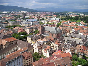
Belfort
Prefecture and commune in Bourgogne-Franche-Comté, France
Distance: Approx. 1039 meters
Latitude and longitude: 47.64,6.85
Belfort (French pronunciation: [bɛlfɔʁ] ; archaic German: Beffert, Beffort) is a city in northeastern France, situated approximately 25 km (16 mi) from the Swiss border. It is the prefecture of the Territoire de Belfort. Belfort is 400 km (250 mi) from Paris and 55 km (34 mi) from Basel.

Lion of Belfort
Monumental sculpture in France
Distance: Approx. 344 meters
Latitude and longitude: 47.63666667,6.86472222
The Lion of Belfort, in Belfort, France, is an 1880 monumental sculpture by Frédéric Auguste Bartholdi, the sculptor of the Statue of Liberty (Liberty Enlightening the World).

Siege of Belfort
Distance: Approx. 215 meters
Latitude and longitude: 47.6379,6.8628
The siege of Belfort (3 November 1870 – 18 February 1871) was a 103-day military assault and blockade of the city of Belfort, France by Prussian forces during the Franco-Prussian War. The French garrison held out until the January 1871 armistice between France and the German Empire obligated French forces to abandon the stronghold in February 1871. Belfort is located in a gap between the mountainous southern Vosges and the Jura Massif, strategically positioned as the gateway between Alsace and central France.

Arrondissement of Belfort
Arrondissement in Bourgogne-Franche-Comté, France
Distance: Approx. 4 meters
Latitude and longitude: 47.63972222,6.86388889
The arrondissement of Belfort is an arrondissement in the Bourgogne-Franche-Comté region of France. It is the only arrondissement of the Territoire de Belfort department. It has 101 communes.
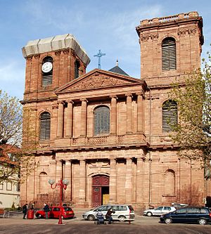
Belfort Cathedral
Distance: Approx. 121 meters
Latitude and longitude: 47.63861111,6.86388889
Belfort Cathedral, otherwise the Cathedral of Saint Christopher of Belfort (French: Cathédrale Saint-Christophe de Belfort), is a Roman Catholic church located in Belfort, Territoire de Belfort, France. The cathedral has been a national monument since 1930. It was declared a minor basilica on 9 May 1952.
Roman Catholic Diocese of Belfort-Montbéliard
Catholic diocese in France
Distance: Approx. 121 meters
Latitude and longitude: 47.63861111,6.86388889
The Diocese of Belfort–Montbéliard (Latin: Dioecesis Belfortiensis–Montis Beligardi; French: Diocèse de Belfort–Montbéliard) is a Latin Church ecclesiastical territory or diocese of the Catholic Church in France. Erected in November 1979, the diocese was split off from the metropolitan Archdiocese of Besançon and remains a suffragan diocese in its ecclesiastical province.

Fort des Basses Perches
French Fort
Distance: Approx. 1557 meters
Latitude and longitude: 47.6261,6.8687
Fort des Basses Perches, also known as Fort Valmy, was built between 1874 and 1877 in Danjoutin and Belfort in northeastern France. It is part of the first ring of fortifications around the city of Belfort. The Forts des Perches were unique among the first group in their re-use of older sites.

Fort des Hautes Perches
Distance: Approx. 1485 meters
Latitude and longitude: 47.6303,6.8779
Fort des Hautes Perches was built between 1874 and 1877 in Danjoutin and Belfort in northeastern France. It is part of the first ring of fortifications around the city of Belfort. The Forts des Perches were unique among the first group in their re-use of older sites.

Belfort station
Distance: Approx. 1030 meters
Latitude and longitude: 47.63328333,6.85395556
Belfort station (French: Gare de Belfort) is the railway station serving the town Belfort, Territoire de Belfort department, eastern France. It is situated on the Paris–Mulhouse and Belfort–Delle lines.

Belfort Synagogue
Jewish synagogue in Belfot, France
Distance: Approx. 565 meters
Latitude and longitude: 47.6381,6.8567
The Belfort Synagogue is a Jewish congregation and synagogue, located at 6, rue de l'As-de-Carreau, in the city center of Belfort, in the Bourgogne-Franche-Comté region of France. The congregation worships in the Ashkenazi rite. The Jewish community was established in the town in the 13th century.
Cantons of Belfort
Distance: Approx. 291 meters
Latitude and longitude: 47.64,6.86
The cantons of Belfort are administrative divisions of the Territoire de Belfort department, in northeastern France. Since the French canton reorganisation which came into effect in March 2015, the town of Belfort is subdivided into 3 cantons. Their seat is in Belfort.

Grand Belfort
Communauté d'agglomération in Bourgogne-Franche-Comté, France
Distance: Approx. 1258 meters
Latitude and longitude: 47.63333333,6.85
Communauté d'agglomération Grand Belfort is an intercommunal structure, centred on the city of Belfort. It is located in the Territoire de Belfort department, in the Bourgogne-Franche-Comté region, eastern France. It was created in January 2017.
Weather in this IP's area
scattered clouds
12 Celsius
12 Celsius
12 Celsius
12 Celsius
1017 hPa
96 %
1017 hPa
974 hPa
10000 meters
1.58 m/s
2.02 m/s
255 degree
37 %
07:57:22
18:37:12