104.103.127.197 - IP Lookup: Free IP Address Lookup, Postal Code Lookup, IP Location Lookup, IP ASN, Public IP
Country:
Region:
City:
Location:
Time Zone:
Postal Code:
IP information under different IP Channel
ip-api
Country
Region
City
ASN
Time Zone
ISP
Blacklist
Proxy
Latitude
Longitude
Postal
Route
Luminati
Country
Region
bc
City
vancouver
ASN
Time Zone
America/Vancouver
ISP
AKAMAI-AS
Latitude
Longitude
Postal
IPinfo
Country
Region
City
ASN
Time Zone
ISP
Blacklist
Proxy
Latitude
Longitude
Postal
Route
IP2Location
104.103.127.197Country
Region
british columbia
City
vancouver
Time Zone
America/Vancouver
ISP
Language
User-Agent
Latitude
Longitude
Postal
db-ip
Country
Region
City
ASN
Time Zone
ISP
Blacklist
Proxy
Latitude
Longitude
Postal
Route
ipdata
Country
Region
City
ASN
Time Zone
ISP
Blacklist
Proxy
Latitude
Longitude
Postal
Route
Popular places and events near this IP address
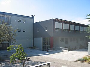
Eric Hamber Secondary School
Secondary school in Vancouver, British Columbia, Canada
Distance: Approx. 610 meters
Latitude and longitude: 49.24,-123.125
Eric Hamber Secondary School is a public secondary school located in the South Cambie neighbourhood of Vancouver, British Columbia, Canada. Eric Hamber is a comprehensive secondary school with approximately 1400 students. Each year, approximately 70% of the senior class graduate with honours standing.
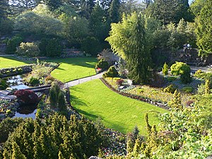
Queen Elizabeth Park, British Columbia
City park in Vancouver, British Columbia, Canada
Distance: Approx. 201 meters
Latitude and longitude: 49.24222222,-123.115
Queen Elizabeth Park is a 130-acre municipal park located in Vancouver, British Columbia, Canada. It is located on top of Little Mountain approximately 125 metres (410 ft) above sea level and is the location of former basalt quarries dug in the beginning of the twentieth century to provide materials for roads in the city.

Bloedel Floral Conservatory
Conservatory and aviary
Distance: Approx. 256 meters
Latitude and longitude: 49.2421,-123.1138
The Bloedel Floral Conservatory is a conservatory and aviary located at the top of Queen Elizabeth Park in Vancouver, British Columbia.
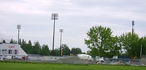
Hillcrest Park
Distance: Approx. 769 meters
Latitude and longitude: 49.244872,-123.108147
Hillcrest Park is located in the Riley Park neighbourhood of Vancouver, British Columbia. It is located immediately north of Queen Elizabeth Park and west of Riley Park. Next to Hillcrest Park is the site containing Nat Bailey Stadium, home of the Vancouver Canadians baseball team; the Millennium Sports Centre, home to both the Phoenix Gymnastics Club and the Pacific Indoor Bowls Club; and the Vancouver Racquets Club.
Little Mountain (British Columbia)
Mountain in Canada
Distance: Approx. 263 meters
Latitude and longitude: 49.24166667,-123.11333333
Little Mountain, elevation 125 m (410 ft), is a mountain in the central part of the city of Vancouver, British Columbia, Canada. The mountain is home to Queen Elizabeth Park, which sits at the top of the mountain, and Nat Bailey Stadium, which is located near the base. The mountain lends its name to the Riley Park–Little Mountain neighbourhood and to the Vancouver-Little Mountain electoral district.
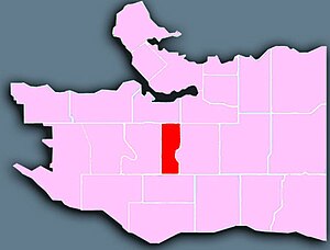
South Cambie
Distance: Approx. 695 meters
Latitude and longitude: 49.246,-123.122
South Cambie is a neighbourhood in the city of Vancouver, British Columbia, Canada, that is generally considered one of the smallest neighbourhoods in the city, both in size and in population. It is wedged between one of the city's largest parks and the upscale neighbourhood of Shaughnessy, and is known for a large cluster of medical facilities.
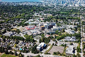
B.C. Women's Hospital & Health Centre
Hospital in British Columbia, Canada
Distance: Approx. 662 meters
Latitude and longitude: 49.243611,-123.124722
B.C. Women's Hospital & Health Centre, an agency of the Provincial Health Services Authority (PHSA), is a Canadian hospital located in Vancouver, British Columbia, Canada, specializing in women's health programs. It is the only facility in Western Canada dedicated to the health of women, newborns and families, and is the largest maternity hospital in the country. It is a teaching hospital and major provincial health care resource, and is a key component in women's health research.
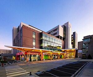
British Columbia Children's Hospital
Hospital in British Columbia, Canada
Distance: Approx. 761 meters
Latitude and longitude: 49.244444,-123.125556
British Columbia Children's Hospital is a medical facility located in Vancouver, British Columbia, and is an agency of the Provincial Health Services Authority. It specializes in health care for patients from birth to 16 years of age (possibly longer if followed by a specialist team). It is also a teaching and research facility for children's medicine.
BC Children's Hospital Foundation
Hospital in British Columbia, Canada
Distance: Approx. 761 meters
Latitude and longitude: 49.244444,-123.125556
BC Children's Hospital Foundation (BCCHF) is a Canadian non-profit registered charity that raises money to support the British Columbia Children's Hospital. The Foundation works with communities to raise funds for essentials including: life-saving equipment, research into childhood diseases, a wide range of medical staff and community child health education programs. Since 1982, BC Children's Hospital Foundation has partnered with children, families, health professionals, and other British Columbia residents to raise funds to support BC Children's Hospital, Sunny Hill Health Centre for Children, and the BC Children's Hospital Research Institute.
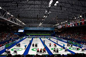
Wheelchair curling at the 2010 Winter Paralympics
Distance: Approx. 738 meters
Latitude and longitude: 49.24486111,-123.10866667
The wheelchair curling competition of the 2010 Winter Paralympics was held at the Vancouver Olympic/Paralympic Centre in Vancouver, British Columbia, Canada, from 13 March to 20 March 2010. Ten teams competed in a single event, a mixed tournament in which men and women competed together.
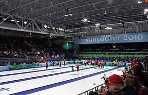
Hillcrest Centre
Athletic center in Vancouver, Canada
Distance: Approx. 748 meters
Latitude and longitude: 49.24444444,-123.10805556
The Hillcrest Centre is a community centre with ice hockey, curling rinks, and an aquatics facility, located at Hillcrest Park in Vancouver, British Columbia, Canada. Construction started in March 2007; it hosted the 2009 World Junior Curling Championships prior to the Olympics. During the 2010 Olympics, it was named the Vancouver Olympic/Paralympic Centre and had a capacity of 6,000 people to host curling at the 2010 Winter Olympics; for the 2010 Paralympics, it hosted the Wheelchair Curling event.
St. John's Vancouver
Large Anglican church in Vancouver, British Columbia, Canada
Distance: Approx. 549 meters
Latitude and longitude: 49.2371,-123.1217
St. John's Vancouver Anglican Church (known in short as "St. John's Vancouver") is an evangelical Anglican church in Vancouver, British Columbia, Canada.
Weather in this IP's area
moderate rain
5 Celsius
0 Celsius
4 Celsius
6 Celsius
989 hPa
89 %
989 hPa
977 hPa
10000 meters
7.2 m/s
60 degree
100 %