Country:
 USA
USARegion:
City:
Latitude and Longitude:
Time Zone:
Postal Code:
IP information under different IP Channel
ip-api
Country
Region
City
ASN
Time Zone
ISP
Blacklist
Proxy
Latitude
Longitude
Postal
Route
IPinfo
Country
Region
City
ASN
Time Zone
ISP
Blacklist
Proxy
Latitude
Longitude
Postal
Route
MaxMind
Country
Region
City
ASN
Time Zone
ISP
Blacklist
Proxy
Latitude
Longitude
Postal
Route
Luminati
Country
USRegion
or
City
hillsboro
ASN
Time Zone
America/Los_Angeles
ISP
Akamai International B.V.
Latitude
Longitude
Postal
db-ip
Country
Region
City
ASN
Time Zone
ISP
Blacklist
Proxy
Latitude
Longitude
Postal
Route
ipdata
Country
Region
City
ASN
Time Zone
ISP
Blacklist
Proxy
Latitude
Longitude
Postal
Route
Popular places and events near this IP address

Washington/Southeast 12th Avenue station
Distance: Approx. 2112 meters
Latitude and longitude: 45.521143,-122.969413
Washington/Southeast 12th Avenue is a light rail station on the MAX Blue Line in Hillsboro, Oregon. Hillsboro's West Precinct is near the station. Opened in 1998, it is the 17th stop westbound on the Westside MAX, and the last eastbound stop prior to crossing the Main Street Bridge.

Hillsboro Airport/Fairgrounds station
Light rail station on the Portland-area MAX Blue Line in northwest Oregon
Distance: Approx. 1970 meters
Latitude and longitude: 45.527066,-122.94611
Hillsboro Airport/Fairgrounds, formerly Fair Complex/Hillsboro Airport, is a light rail station on the MAX Blue and Red lines in Hillsboro, Oregon, United States. It is the 16th stop westbound on the Westside MAX, and the last westbound stop prior to crossing the Main Street Bridge. The station is located close to the Westside Commons – the 2019-adopted new name for the Washington County Fair Complex – and Hillsboro Airport, a major general-aviation facility in Hillsboro, and the location of the Oregon International Airshow in the summer.
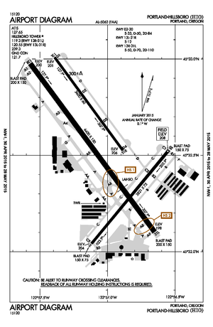
Hillsboro Airport
Airport in Hillsboro, Oregon
Distance: Approx. 1092 meters
Latitude and longitude: 45.54039389,-122.949825
Hillsboro Airport (IATA: HIO, ICAO: KHIO), also known as Portland–Hillsboro Airport, is a corporate, general aviation and flight-training airport serving the city of Hillsboro, in Washington County, Oregon, United States. It is one of three airports in the Portland, Oregon, metropolitan area owned and operated by the Port of Portland. Established in 1928, it is Oregon's second busiest airport (in terms of total aircraft operations) at over 200,000 operations annually.

Main Street Bridge (Hillsboro, Oregon)
Light-rail bridge over Main and 18th Streets in Hillsboro, Oregon
Distance: Approx. 2035 meters
Latitude and longitude: 45.521416,-122.963618
The Hillsboro Main Street Bridge is a concrete tied arch bridge located in Hillsboro, Oregon. The bridge carries light rail traffic on the MAX Blue Line over Main Street and 18th Street. Completed in 1997, the 425-foot-long (130 m) bridge was built with a 78-foot-tall (24 m) arch in the center.
Hillsboro Public Library
Library in Oregon, US
Distance: Approx. 2175 meters
Latitude and longitude: 45.54288889,-122.93627778
The Hillsboro Public Library is a two-location public library system in Hillsboro, Oregon, United States. First opened in 1914 in a Carnegie library building, the system provides services to a population area of 137,000 people. As of 2015, the system had a usage of 922,000 visits per year, with circulation nearly 3 million items per year.

TriQuint Semiconductor
American semiconductor company
Distance: Approx. 2173 meters
Latitude and longitude: 45.540308,-122.935939
TriQuint Semiconductor was a semiconductor company that designed, manufactured, and supplied high-performance RF modules, components and foundry services. The company was founded in 1985 in Beaverton, Oregon before moving to neighboring Hillsboro, Oregon. In February 2014, Greensboro, North Carolina-based RF Micro Devices and TriQuint announced a merger in which the new company would be Qorvo, Inc., with the merger completed on January 1, 2015.

Charles Shorey House
Historic house in Oregon, United States
Distance: Approx. 2142 meters
Latitude and longitude: 45.52222222,-122.97527778
The Charles Shorey House is a two-story wood home on Main Street in downtown Hillsboro, Oregon, United States. Completed circa 1908, the Queen Anne style structure was built by Charles Shorey. The building was added to the National Register of Historic Places in 1989.

Hamby Park
Distance: Approx. 1647 meters
Latitude and longitude: 45.53361111,-122.98305556
U. J. Hamby Park is a nearly seven acre municipal park in northwest Hillsboro, Oregon, United States. Opened in 1990, the park includes nature trails along a small creek as well as a basketball court and grass lawn. The park is named after the longtime Chevrolet dealership owner, whose family donated the land to the city in 1986.
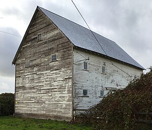
Manning–Kamna Farm
Historic house in Oregon, United States
Distance: Approx. 1680 meters
Latitude and longitude: 45.55027778,-122.97916667
The Manning–Kamna Farm is a private farm adjacent to Hillsboro in Washington County, Oregon, United States. Settled in the 1850s, ten buildings built between 1883 and 1930 still stand, including the cross-wing western farmhouse. These ten structures comprise the buildings added to the National Register of Historic Places in 2007 as an example of a farm in the region from the turn of the 20th century.

American Blimp Corporation
US airship manufacturer
Distance: Approx. 733 meters
Latitude and longitude: 45.53913,-122.95444
American Blimp Corporation (ABC) is an American privately owned Hillsboro, Oregon-based company that is the largest manufacturer of blimps in the United States. It manufactures the hardware and rigging for the Lightship and Spector brands of airships. In 2012, American Blimp Corporation and The Lightship Group were acquired by Van Wagner Communications LLC, and became referred to as the Van Wagner Airship Group.

Bicentennial Park (Hillsboro, Oregon)
Neighborhood park in Hillsboro, Oregon
Distance: Approx. 2057 meters
Latitude and longitude: 45.52166667,-122.95805556
Bicentennial Park is a neighborhood park in Hillsboro in the U.S. state of Oregon. Opened in 1976, it is named for the United States' Bicentennial and also honors the city's one-hundredth year as a city. Located at northeast 25th Avenue and Parkwood, the park covers about 4 acres (1.6 ha) and includes a water reservoir, a fire station, a playground, and a soccer field among other amenities.
Classic Aircraft Aviation Museum
Aviation museum in Hillsboro, Oregon
Distance: Approx. 1252 meters
Latitude and longitude: 45.532628,-122.951313
The Classic Aircraft Aviation Museum is an aviation museum located in Hillsboro in the U.S. state of Oregon. Started in 1998, the one of the museum's with about 5 aircraft is located at the Hillsboro Airport in the Portland metropolitan area. Aircraft at the museum are either maintained in flyable condition or are restored so that they can be flown once again.
Weather in this IP's area
clear sky
17 Celsius
17 Celsius
16 Celsius
18 Celsius
1011 hPa
89 %
1011 hPa
1004 hPa
10000 meters
2.06 m/s
240 degree
06:42:35
19:36:24