103.98.2.176 - IP Lookup: Free IP Address Lookup, Postal Code Lookup, IP Location Lookup, IP ASN, Public IP
Country:
Region:
City:
Location:
Time Zone:
Postal Code:
ISP:
ASN:
language:
User-Agent:
Proxy IP:
Blacklist:
IP information under different IP Channel
ip-api
Country
Region
City
ASN
Time Zone
ISP
Blacklist
Proxy
Latitude
Longitude
Postal
Route
db-ip
Country
Region
City
ASN
Time Zone
ISP
Blacklist
Proxy
Latitude
Longitude
Postal
Route
IPinfo
Country
Region
City
ASN
Time Zone
ISP
Blacklist
Proxy
Latitude
Longitude
Postal
Route
IP2Location
103.98.2.176Country
Region
west bengal
City
siuri
Time Zone
Asia/Kolkata
ISP
Language
User-Agent
Latitude
Longitude
Postal
ipdata
Country
Region
City
ASN
Time Zone
ISP
Blacklist
Proxy
Latitude
Longitude
Postal
Route
Popular places and events near this IP address

Birbhum district
District in West Bengal, India
Distance: Approx. 984 meters
Latitude and longitude: 23.91,87.527
Birbhum district (IPA: [biːrbʰuːm]) is an administrative unit in the Indian state of West Bengal. It is the northernmost district of Burdwan division—one of the five administrative divisions of West Bengal. The district headquarters is in Suri.

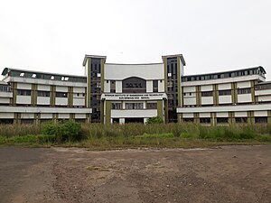
Birbhum Institute of Engineering & Technology
Distance: Approx. 2260 meters
Latitude and longitude: 23.9354803,87.5248736
Birbhum Institute of Engineering and Technology or BIET is a West Bengal government-aided engineering college in West Bengal, India. It offers different undergraduate and postgraduate courses in Engineering. It was established in 1999 by an NGO named ICARE under the guidance of educationist Padmashri Late Ramaranjan Mukherji, Ex-President of India and then Finance Minister Shri Pranab Mukherjee and Lok Sabha Speaker Shri Somnath Chatterjee.

Suri Vidyasagar College
Distance: Approx. 2085 meters
Latitude and longitude: 23.8979776,87.5328689
Suri Vidyasagar College, established in 1942, is a government affiliated college located at Suri in the Birbhum district of West Bengal. It is affiliated to University of Burdwan and teaches arts, science and commerce.
Birbhum Lok Sabha constituency
Lok Sabha constituency in West Bengal
Distance: Approx. 0 meters
Latitude and longitude: 23.9167,87.5333
Birbhum Lok Sabha constituency is one of the 543 parliamentary constituencies in India. The constituency centres on the western part of Birbhum district in West Bengal. All the seven assembly segments of No.

Suri Sadar subdivision
Subdivision in West Bengal, India
Distance: Approx. 498 meters
Latitude and longitude: 23.92,87.53
Suri Sadar subdivision is an administrative subdivision of Birbhum district in the state of West Bengal, India.
Kankagrambhukti
Distance: Approx. 0 meters
Latitude and longitude: 23.9167,87.5333
Kankagrambhukti (Bengali: কঙ্কগ্রামভুক্তি) was an ancient and medieval region/ territory spread across what are now Birbhum, Purba Bardhaman, Paschim Bardhaman and Murshidabad districts in the Indian state of West Bengal. Ancient Rarh region was divided into several smaller regions – Kankangrambhukti, Bardhamanbhukti and Dandabhukti, as part of the Gupta Empire. Kankagram was located on the banks of the Hooghly.
Birbhum Mahavidyalaya
Distance: Approx. 340 meters
Latitude and longitude: 23.9142482,87.5352983
Birbhum Mahavidyalaya, established in 1979, is a government affiliated college at Suri in the Birbhum district of West Bengal. It is affiliated to University of Burdwan and teaches arts, science and commerce.

Suri, Birbhum
City in West Bengal, India
Distance: Approx. 984 meters
Latitude and longitude: 23.91,87.527
Suri (pronounced [sIʊərɪ]) (also spelt as Siuri) is a city and a municipality in the Indian state of West Bengal. It is the headquarters of the Birbhum district.

Sree Ramkrishna Silpa Vidyapith
Distance: Approx. 2155 meters
Latitude and longitude: 23.9328385,87.5216107
Sree Ramkrishna Silpa Vidyapith , established in 1953, is a government polytechnic located in Suri, Birbhum district, West Bengal. This polytechnic is affiliated to the West Bengal State Council of Technical Education, and recognised by AICTE, New Delhi. This polytechnic offers diploma courses in Civil, Electrical, Mechanical and Pharmacy.

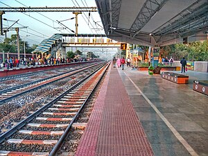
Siuri railway station
Railway station in West Bengal, India
Distance: Approx. 2948 meters
Latitude and longitude: 23.890301,87.531016
Siuri railway station (Station Code- SURI) is one of the major railway stations on Andal–Sainthia branch line under Asansol railway division. It serves Suri, the district Headquarters of Birbhum district in the Indian state of West Bengal, and the adjoining villages. The railway station is owned by Indian Railways and operated by Eastern Railway.
Kalipur, Birbhum
Village in West Bengal, India
Distance: Approx. 2914 meters
Latitude and longitude: 23.9048,87.5078
Kalipur is a Village in Suri I CD block in Suri Sadar subdivision of Birbhum district, West Bengal, India.

Suri Sadar Hospital
Hospital in West Bengal, India
Distance: Approx. 1523 meters
Latitude and longitude: 23.915044,87.518443
Suri Sadar Hospital is a district hospital situated at Suri, the District Headquarters of Birbhum district, India. It is also one of the three super-specialty hospitals built in Birbhum district. Apart from people of Suri, people of neighbouring villages and towns (such as, Rajnagar, Mohammad Bazar, Purandarpur, Sainthia etc.) and even the people of neighbouring state Jharkhand also depend on this hospital.
Weather in this IP's area
clear sky
16 Celsius
14 Celsius
16 Celsius
16 Celsius
1014 hPa
45 %
1014 hPa
1005 hPa
10000 meters
1.21 m/s
1.27 m/s
287 degree