Country:
Region:
City:
Latitude and Longitude:
Time Zone:
Postal Code:
IP information under different IP Channel
ip-api
Country
Region
City
ASN
Time Zone
ISP
Blacklist
Proxy
Latitude
Longitude
Postal
Route
Luminati
Country
ASN
Time Zone
Asia/Kolkata
ISP
YOTTA NETWORK SERVICES PRIVATE LIMITED
Latitude
Longitude
Postal
IPinfo
Country
Region
City
ASN
Time Zone
ISP
Blacklist
Proxy
Latitude
Longitude
Postal
Route
db-ip
Country
Region
City
ASN
Time Zone
ISP
Blacklist
Proxy
Latitude
Longitude
Postal
Route
ipdata
Country
Region
City
ASN
Time Zone
ISP
Blacklist
Proxy
Latitude
Longitude
Postal
Route
Popular places and events near this IP address
Jaypee Institute of Information Technology
Institute of higher education in India
Distance: Approx. 1137 meters
Latitude and longitude: 28.62980556,77.03894444
Jaypee Institute of Information Technology (JIIT) is a private deemed-to-be-university, situated in Noida, Gautam Buddha Nagar district, Uttar Pradesh, India.
Hastsal
Suburb of New Delhi, India
Distance: Approx. 2296 meters
Latitude and longitude: 28.634,77.053
Village Hastsal is a census town and village in West district in the Indian Union Territory of Delhi.

Uttam Nagar West metro station
Metro station in Delhi, India
Distance: Approx. 2999 meters
Latitude and longitude: 28.62172806,77.05569806
The Uttam Nagar West metro station is located on the Blue Line of the Delhi Metro.

Nawada metro station
Metro station in Delhi, India
Distance: Approx. 2314 meters
Latitude and longitude: 28.62019444,77.04511111
The Nawada metro station is located on the Blue Line of the Delhi Metro.

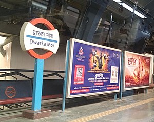
Dwarka Mor metro station
Metro station in Delhi, India
Distance: Approx. 1884 meters
Latitude and longitude: 28.61930556,77.03338889
The Dwarka Mor metro station or Dwarka Sector 15 is located on the Blue Line of the Delhi Metro. It is the nearest metro station to Netaji Subhas University of Technology and Deen Dayal Upadhyaya College.
Dwarka metro station
Metro station in Delhi, India
Distance: Approx. 2419 meters
Latitude and longitude: 28.615,77.02280556
The Dwarka is a metro station is located on the Blue Line and Grey Line of the Delhi Metro. The Station is an interchange station between the lines. Some of the Metro Services terminate here of the blue line.
Nangli Sakrawati
Village in Delhi, India
Distance: Approx. 2921 meters
Latitude and longitude: 28.6199,77.0059
Nangli Sakrawati is a village on the outskirts of Najafgarh in South West Delhi district of the National Capital Territory of Delhi.
Uttam Nagar Assembly constituency
Constituency of the Delhi legislative assembly in India
Distance: Approx. 3114 meters
Latitude and longitude: 28.619,77.055
Uttam Nagar Assembly constituency is one of the 70 Delhi Legislative Assembly constituencies of the National Capital Territory in northern India.
Matiala Assembly constituency
Legislative assembly seat in Delhi
Distance: Approx. 3562 meters
Latitude and longitude: 28.61,77.051
Matiala Assembly constituency is one of the 70 Delhi Legislative Assembly constituencies of the National Capital Territory in northern India. Gulab Singh Yadav of Aam Aadmi Party is the current MLA from Matiala.
Netaji Subhas University of Technology
State university in Dwarka, Delhi, India
Distance: Approx. 2907 meters
Latitude and longitude: 28.61097222,77.03847222
Netaji Subhas University of Technology (NSUT), formerly Netaji Subhas Institute of Technology (NSIT) is a state university located in Dwarka, Delhi, India. In 2018, the institute was granted university status, changing its name to Netaji Subhas University of Technology (NSUT).

Nangli metro station
Metro station in Delhi, India
Distance: Approx. 2799 meters
Latitude and longitude: 28.61723889,77.0104
The Nangli metro station is located on the Grey Line of the Delhi Metro. The station was opened for public on 4 October 2019. As part of Phase III of Delhi Metro, Nangli is a metro station of the Grey Line.

Mini Qutub Minar
Distance: Approx. 2296 meters
Latitude and longitude: 28.634,77.053
The Mini Qutub Minar (local: Chhota Qutub Minar, Mini Minar, Kaushal Minar, Hastsal ki Laat) is a minaret tower in Hastsal village, near Uttam Nagar in West Delhi, Delhi, India. It was built in the 1650 by Mughal emperor, Shah Jahan (reign, 1628-1658) near his hunting lodge in Hasthal. The three storeyed tower is 16.87 meters (55 feet) tall and stands on a raised octagonal platform.
Weather in this IP's area
fog
21 Celsius
22 Celsius
21 Celsius
21 Celsius
1012 hPa
88 %
1012 hPa
988 hPa
800 meters
1.54 m/s
290 degree
06:43:09
17:29:23
