Country:
Region:
City:
Latitude and Longitude:
Time Zone:
Postal Code:
IP information under different IP Channel
ip-api
Country
Region
City
ASN
Time Zone
ISP
Blacklist
Proxy
Latitude
Longitude
Postal
Route
Luminati
Country
Region
qld
City
brisbane
ASN
Time Zone
Australia/Brisbane
ISP
Leaptel
Latitude
Longitude
Postal
IPinfo
Country
Region
City
ASN
Time Zone
ISP
Blacklist
Proxy
Latitude
Longitude
Postal
Route
db-ip
Country
Region
City
ASN
Time Zone
ISP
Blacklist
Proxy
Latitude
Longitude
Postal
Route
ipdata
Country
Region
City
ASN
Time Zone
ISP
Blacklist
Proxy
Latitude
Longitude
Postal
Route
Popular places and events near this IP address
Milton railway station, Brisbane
Railway station in Brisbane, Queensland, Australia
Distance: Approx. 686 meters
Latitude and longitude: -27.4689,153.0052
Milton railway station is located on the Main line in Queensland, Australia. It serves the Brisbane suburb of Milton. The station includes a walkbridge to Lang Park and is also immediately adjacent the Castlemaine Perkins brewery.
Green Flea Markets (West End)
Distance: Approx. 414 meters
Latitude and longitude: -27.478701,153.004559
The Green Flea Markets are held every Saturday morning in Davies Park, West End, Queensland (Australia). The Market site is home to a number of giant fig trees which have recently become infected with a fungal disease (Phellinus noxius) that is spreading all over Queensland. This is particularly interesting as the treatment of the trees is threatening the existence of this unique market.

Milton Courts
Distance: Approx. 708 meters
Latitude and longitude: -27.4695,153.0006
Milton Courts (now Frew Park) was a tennis venue located in Milton, Brisbane, Australia. The complex consisted of 19 hard courts and four grass courts. The main arena seated 7,000 people and opened in 1915.

West End State School
Historic site in Queensland, Australia
Distance: Approx. 641 meters
Latitude and longitude: -27.4796,153.0081
West End State School is a heritage-listed state school at 24 Vulture Street, West End, City of Brisbane, Queensland, Australia. It was built from 1891 to 1960. It was added to the Queensland Heritage Register on 24 April 2018.
Moorlands, Auchenflower
Historic site in Queensland, Australia
Distance: Approx. 710 meters
Latitude and longitude: -27.479,152.9986
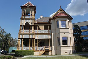
Moorlands is a heritage-listed villa at 451 Coronation Drive, Auchenflower, Queensland, Australia. It was designed by Richard Gailey and was built c. 1892 by contractor Arthur Smith. It was added to the Queensland Heritage Register on 21 August 1992.

Cook Terrace
Historic site in Queensland, Australia
Distance: Approx. 325 meters
Latitude and longitude: -27.4724,153.0057
Cook Terrace is a heritage-listed terrace house at 249 Coronation Drive, Milton, City of Brisbane, Queensland, Australia. It was built from 1888 to c. 1900. It is also known as Gloralgar Flats and Milton Terrace.

Milton House, Milton
Historic site in Queensland, Australia
Distance: Approx. 400 meters
Latitude and longitude: -27.4717,153.0058
Milton House is a heritage-listed villa at 50 McDougall Street, Milton, City of Brisbane, Queensland, Australia. It was built from c. 1852. It was added to the Queensland Heritage Register on 21 October 1992.

Gas Stripping Tower
Historic site in Queensland, Australia
Distance: Approx. 504 meters
Latitude and longitude: -27.4793,153.0026
The Gas Stripping Tower is a heritage-listed tower at 277 Montague Road, West End, Queensland, Australia. It was designed by Robert Dempster & Sons Ltd and built in 1912. It was added to the Queensland Heritage Register on 21 October 1992.

West End Gasworks
Historic site in Queensland, Australia
Distance: Approx. 658 meters
Latitude and longitude: -27.4809,153.0038
West End Gasworks is a heritage-listed gasworks at 321 Montague Road, West End, Queensland, Australia. It is also known as South Brisbane Gas and Light Company Works. It was added to the Queensland Heritage Register on 22 October 1999.

Astrea, West End
Historic site in Queensland, Australia
Distance: Approx. 612 meters
Latitude and longitude: -27.4777,153.0096
Astrea is a heritage-listed duplex (building) at 19 Bank Street, West End, Queensland, Australia. It was built c. 1888 for Fedder Jensen. It was added to the Queensland Heritage Register on 21 October 1992.
Toowong FC
Football club
Distance: Approx. 452 meters
Latitude and longitude: -27.47416667,152.99972222
Toowong FC is an Australian football (soccer) club based in Auchenflower, Queensland, Australia. The club was established in 1921, and currently plays in the Football Brisbane Men's Premier League (and reserves), Women's Capital League and City League competitions. The club also has junior teams for all ages with a strong focus on female participation.
Davies Park
Distance: Approx. 410 meters
Latitude and longitude: -27.47861111,153.005
Davies Park is a sporting venue in the suburb of West End in Brisbane, Queensland, Australia. It is grass. It is located at the corner of Jane St, Montague Road & Riverside Drive, West End.
Weather in this IP's area
moderate rain
23 Celsius
23 Celsius
22 Celsius
24 Celsius
1017 hPa
88 %
1017 hPa
1016 hPa
10000 meters
4.12 m/s
340 degree
04:54:03
18:09:04


