Country:
Region:
City:
Latitude and Longitude:
Time Zone:
Postal Code:
IP information under different IP Channel
ip-api
Country
Region
City
ASN
Time Zone
ISP
Blacklist
Proxy
Latitude
Longitude
Postal
Route
Luminati
Country
ASN
Time Zone
Asia/Jakarta
ISP
PT Bank Pembangunan Daerah Jawa Barat & Banten
Latitude
Longitude
Postal
IPinfo
Country
Region
City
ASN
Time Zone
ISP
Blacklist
Proxy
Latitude
Longitude
Postal
Route
db-ip
Country
Region
City
ASN
Time Zone
ISP
Blacklist
Proxy
Latitude
Longitude
Postal
Route
ipdata
Country
Region
City
ASN
Time Zone
ISP
Blacklist
Proxy
Latitude
Longitude
Postal
Route
Popular places and events near this IP address

Bandung
City and capital of West Java, Indonesia
Distance: Approx. 904 meters
Latitude and longitude: -6.912,107.6097
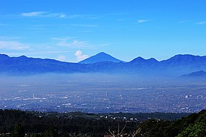
Bandung is the capital city of the West Java province of Indonesia. Located on the island of Java, Greater Bandung (Bandung Basin Metropolitan Area / BBMA) is the country's second-largest and second most populous metropolitan area, with over 11 million inhabitants. Situated 768 meters (2,520 feet) above sea level (the highest point in the North area is at an altitude of 1,050 meters (3,445 feet), and the lowest in the South at 675 meters (2,215 feet) above sea level), approximately 140 kilometres (87 miles) southeast of Jakarta, Bandung has cooler year-round temperatures than most other Indonesian cities.

SMU St. Angela
Private school in Bandung, West Java, Indonesia
Distance: Approx. 889 meters
Latitude and longitude: -6.91205556,107.61044444
Santa Angela is a private Catholic school located at Jalan Merdeka 24 Bandung, West Java. It was founded by Dutch Ursuline nuns in 1905. It is listed as a local heritage site, preventing unauthorised changed to the building's structure.

Braga Street
Distance: Approx. 271 meters
Latitude and longitude: -6.91805556,107.60955556
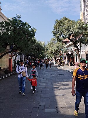
Braga Street (Indonesian: Jalan Braga, Sundanese: ᮏᮜᮔ᮪ ᮘᮢᮌ) is a street in the center of Bandung, Indonesia, famous in 1920s colonial Indonesia as a promenade street. A European ambiance of chic cafes, boutiques, and restaurants along the street propelled Bandung to attain the Dutch nickname Parijs van Java ("Paris of Java"). Braga Street begins on a T-junction with Asia-Afrika Street (formerly De Groote Postweg), running north until the city council (balaikota).
Hotel Savoy Homann
Hotel in Bandung, Indonesia
Distance: Approx. 243 meters
Latitude and longitude: -6.92211,107.61036
The Hotel Savoy Homann is a historic four stars hotel located on Asia Afrika Street, Bandung, Indonesia. It was built in 1939, replacing the 19th century Homann Hotel. Designed by the Dutch architect Albert Aalbers, the hotel features art deco exterior and interior, and historic furniture.

Bandung metropolitan area
Metropolitan area in West Java, Indonesia
Distance: Approx. 667 meters
Latitude and longitude: -6.92388889,107.60638889
The Bandung Metropolitan Area, officially called the Bandung Basin (Sundanese: ᮎᮨᮊᮥᮍᮔ᮪ ᮘᮔ᮪ᮓᮥᮀ, romanized: Cekungan Bandung); or Greater Bandung (Bandung Raya), is a metropolitan area surrounding the city of Bandung, West Java, Indonesia. It was home to over nine million people in mid 2023 and is composed of regencies and cities previously part of the Dutch East Indies era "Central Priangan Residency" administration. Due to ongoing development in urban areas between Bandung, Kertajati International Airport, Aerotropolis and Patimban International Seaport, the West Java provincial government and the Regional Planning Board (BAPPEDA) has prepared and publicized a blueprint for a newly defined (extended) Bandung Metropolitan area with a total area more than 5,500 km2 and a population greater than 11 million people.

Bandung railway station
Railway station in Indonesia
Distance: Approx. 1143 meters
Latitude and longitude: -6.91416667,107.6025
Bandung Station (BD) (Indonesian: Stasiun Bandung, Sundanese: ᮞ᮪ᮒᮞᮤᮇᮔ᮪ ᮘᮔ᮪ᮓᮥᮀ) or Hall Station (Stasiun Hall) is the largest train station in Bandung, West Java, Indonesia. Managed by Kereta Api Indonesia and its subsidiary KAI Commuter, it serves as the main station for Operational Area II Bandung of the KAI, administering Bandung and Priangan areas. The station, which is located at an altitude of +709 meters, is also the main station for the Bandung metropolitan area.
Merdeka Building
Building in Bandung
Distance: Approx. 233 meters
Latitude and longitude: -6.92114,107.60922
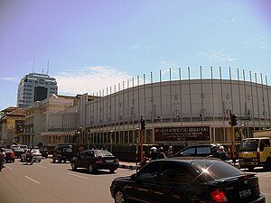
Merdeka Building (Indonesian: Gedung Merdeka) is an Art Deco building in Jalan Asia-Afrika, Bandung, Indonesia. Today it serves as a museum displaying collections and photographs of the Asian–African Conference, the first Non-Aligned Movement event, which was held there in 1955.
Banceuy Prison
Distance: Approx. 602 meters
Latitude and longitude: -6.9147,107.61
Banceuy Prison (Indonesian: Penjara Banceuy) was a prison located in Bandung, West Java, Indonesia. Banceuy Prison was built in 1877 by the Dutch colonial government. It is located in Banceuy Street, 500 meters to the west of the Merdeka Building-Asian-African Conference Museum complex.

Lake Bandung
Former lake
Distance: Approx. 667 meters
Latitude and longitude: -6.92388889,107.60638889
Lake Bandung (Sundanese: Situ Hiang) was a prehistoric lake located in and around the city of Bandung, Parahyangan highlands, West Java, Indonesia. believed to exist between 126,000 and 20,000 BCE in the Pleistocene due to the violent eruption of Mount Sunda that blocked the Citarum River, causing the lowlands to begin to be inundated with water, eventually forming a lake. Today, the lake had dried out and revealed the bottom of a geological basin known as the Bandung basin.
Grand Mosque of Bandung
Mosque in Bandung, West Java, Indonesia
Distance: Approx. 558 meters
Latitude and longitude: -6.921734,107.606259
The Grand Mosque of Bandung (Indonesian: Masjid Raya Bandung), previously known as the Great Mosque of Bandung (Masjid Agung Bandung), is a mosque in Bandung, the a provincial capital of West Java, Indonesia. The mosque received the status of provincial mosque in West Java Province in 2004. It is located on the east side of the alun-alun of Bandung.

Al-Imtizaj Mosque
Mosque in Bandung, West Java, Indonesia
Distance: Approx. 353 meters
Latitude and longitude: -6.91944444,107.60786111
The Al-Imtizaj Mosque (Indonesian: Masjid Al-Imtizaj) is a mosque in Bandung, West Java, Indonesia.
Lautze 2 Mosque
Mosque in Bandung, West Java, Indonesia
Distance: Approx. 261 meters
Latitude and longitude: -6.91802778,107.61225
The Lautze 2 Mosque (Indonesian: Masjid Lautze 2) is a mosque in Bandung, West Java, Indonesia.
Weather in this IP's area
overcast clouds
23 Celsius
23 Celsius
23 Celsius
23 Celsius
1012 hPa
87 %
1012 hPa
933 hPa
10000 meters
0.45 m/s
0.89 m/s
73 degree
89 %
05:21:29
17:45:23


