Country:
 Indonesia
Region:
City:
Latitude and Longitude:
Time Zone:
Postal Code:
IP information under different IP Channel
ip-api
Country
Region
City
ASN
Time Zone
ISP
Blacklist
Proxy
Latitude
Longitude
Postal
Route
IPinfo
Country
Region
City
ASN
Time Zone
ISP
Blacklist
Proxy
Latitude
Longitude
Postal
Route
MaxMind
Country
Region
City
ASN
Time Zone
ISP
Blacklist
Proxy
Latitude
Longitude
Postal
Route
Luminati
Country
IDASN
Time Zone
Asia/Jakarta
ISP
PT Telkom Satelit Indonesia
Latitude
Longitude
Postal
db-ip
Country
Region
City
ASN
Time Zone
ISP
Blacklist
Proxy
Latitude
Longitude
Postal
Route
ipdata
Country
Region
City
ASN
Time Zone
ISP
Blacklist
Proxy
Latitude
Longitude
Postal
Route
Popular places and events near this IP address

Bogor
City in Java, Indonesia
Distance: Approx. 6638 meters
Latitude and longitude: -6.5966,106.7972
Bogor City (Indonesian: Kota Bogor) or Bogor (Sundanese: ᮘᮧᮌᮧᮁ, Dutch: Buitenzorg) is a city in the West Java province, Indonesia. Located around 60 kilometers (37 mi) south of the national capital of Jakarta, Bogor is the 6th largest city in the Jakarta metropolitan area and the 14th overall nationwide. The city covers an area of 111.39 km2, and it had a population of 950,334 in the 2010 Census and 1,043,070 in the 2020 Census.

Pajajaran Stadium
Distance: Approx. 4792 meters
Latitude and longitude: -6.577165,106.797661
Pajajaran Stadium is a multi-use stadium in Bogor, Indonesia. It is currently used mostly for football matches and is used as the home venue for PSB Bogor. The stadium holds 12,000 people.

IPB University
Distance: Approx. 5525 meters
Latitude and longitude: -6.55405556,106.72341667
IPB University (Indonesian: Institut Pertanian Bogor, abbreviated as IPB) is a state-run agricultural university based in the regency of Bogor, Indonesia. IPB has long been considered one of the "Big 5" universities in Indonesia, along with University of Indonesia, Bandung Institute of Technology, Gadjah Mada University and Airlangga University.
Roman Catholic Diocese of Bogor
Roman Catholic diocese on Java, Indonesia
Distance: Approx. 5499 meters
Latitude and longitude: -6.5833,106.8
The Roman Catholic Diocese of Bogor (Latin: Bogoren(sis)) is a diocese located in the city of Bogor in the ecclesiastical province of Jakarta in Indonesia.

Bogor railway station
Railway station in Indonesia
Distance: Approx. 6129 meters
Latitude and longitude: -6.5942707,106.7908108
Bogor Station (BOO), formerly Buitenzorg Station, is a railway station located in the city of Bogor, West Java. This station serves as the terminus for the Red Line service of KRL Commuterline. The station has five island platforms and two side platforms.

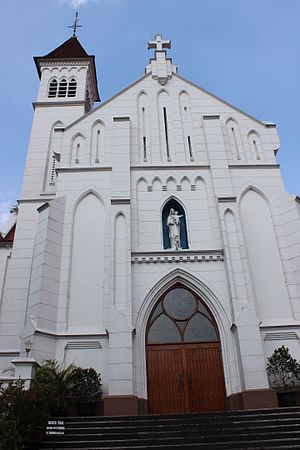
Blessed Virgin Mary Cathedral, Bogor
Catholic church in Indonesia
Distance: Approx. 6506 meters
Latitude and longitude: -6.597,106.7932
Bogor Cathedral, formally the Cathedral of the Blessed Virgin Mary (Indonesian: Gereja Santa Perawan Maria), is a historic church building in the Diocese of Bogor in Bogor, West Java, Indonesia. A church in Buitenzorg (Dutch name for the area) in 1894 served both Protestants and Catholics. The cathedral was built 1905.

Cilebut railway station
Railway station in Indonesia
Distance: Approx. 3430 meters
Latitude and longitude: -6.53052778,106.80058333
Cilebut Station (CLT) is a railway station located in East Cilebut, Sukaraja, Bogor Regency, West Java that was opened in 1873. The station is located at an altitude of +171 meters above sea level. This station serves KRL Commuterline trains serving Jabodetabek area.

Bojong Gede railway station
Railway station in Indonesia
Distance: Approx. 6030 meters
Latitude and longitude: -6.49334,106.794938
Bojong Gede Station (BJD) is a railway station located in Bojong Gede, Bojong Gede, Bogor Regency, West Java that was opened in 1873. The station is located at an altitude of +140 meters above sea level. This station serves as a KRL Commuterline train stop serving the Jabodetabek area.

Bogor Paledang railway station
Railway station in Indonesia
Distance: Approx. 6500 meters
Latitude and longitude: -6.597889,106.790544
Bogor Paledang Station (BOP) is a railway station located in the city of Bogor, West Java. The station is located at the altitude of +246 meters above sea level. It opened in 2013 to cut down human traffic in Bogor station which now serves commuter trains, KRL Commuterline.
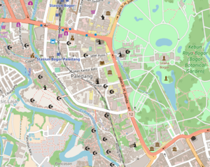
Paledang, Bogor
Village in West Java, Indonesia
Distance: Approx. 6683 meters
Latitude and longitude: -6.5991328,106.7920068
Paledang is one of the areas in Central Bogor District, Bogor, West Java, Indonesia. It encompasses the Bogor Botanical Gardens and Istana, plus a bustling urban area to the west between the Gardens and the river. Bogor Paledang railway station serves the Bogor-Sukabumi route.

Atang Sendjaja Air Force Base
Military airport in Bogor, West Java, Indonesia
Distance: Approx. 1892 meters
Latitude and longitude: -6.53888889,106.75527778
Atang Sendjaja or Atang Senjaya Air Force Base (ICAO: WIAJ) is a small airbase operated by Indonesian Air Force. Located in Kemang, Bogor Regency, West Java, Indonesia, this airport has a single runway lane of 1.400 m. The airbase is named after Atang Sendjaja, an Indonesian Air Force helicopter pilot.

Bogor City Regional House of Representatives
Municipal legislature of the city of Bogor, West Java, Indonesia
Distance: Approx. 6408 meters
Latitude and longitude: -6.59611111,106.79305556
The Bogor City Regional House of Representatives is the unicameral municipal legislature of the city of Bogor, West Java, Indonesia. It has 50 members, who are elected every five years, simultaneously with the national legislative election.
Weather in this IP's area
scattered clouds
34 Celsius
37 Celsius
32 Celsius
34 Celsius
1008 hPa
48 %
1008 hPa
989 hPa
10000 meters
3.58 m/s
3.16 m/s
338 degree
50 %
05:29:40
17:45:45