103.91.193.75 - IP Lookup: Free IP Address Lookup, Postal Code Lookup, IP Location Lookup, IP ASN, Public IP
Country:
Region:
City:
Location:
Time Zone:
Postal Code:
ISP:
ASN:
language:
User-Agent:
Proxy IP:
Blacklist:
IP information under different IP Channel
ip-api
Country
Region
City
ASN
Time Zone
ISP
Blacklist
Proxy
Latitude
Longitude
Postal
Route
db-ip
Country
Region
City
ASN
Time Zone
ISP
Blacklist
Proxy
Latitude
Longitude
Postal
Route
IPinfo
Country
Region
City
ASN
Time Zone
ISP
Blacklist
Proxy
Latitude
Longitude
Postal
Route
IP2Location
103.91.193.75Country
Region
new south wales
City
casino
Time Zone
Australia/Sydney
ISP
Language
User-Agent
Latitude
Longitude
Postal
ipdata
Country
Region
City
ASN
Time Zone
ISP
Blacklist
Proxy
Latitude
Longitude
Postal
Route
Popular places and events near this IP address

Casino, New South Wales
Town in New South Wales, Australia
Distance: Approx. 974 meters
Latitude and longitude: -28.86666667,153.05
Casino is a town in the Northern Rivers area of New South Wales, Australia, with a population of 12,298 people at the 2021 census. It lies on the banks of the Richmond River and is situated at the junction of the Bruxner Highway and the Summerland Way. It is located 726 km (451 mi) north of Sydney and 228 km (142 mi) south of Brisbane.

Richmond Valley Council
Local government area in New South Wales, Australia
Distance: Approx. 974 meters
Latitude and longitude: -28.86666667,153.05
Richmond Valley Council (RVC) is a local government area on the Northern Rivers region of north-eastern New South Wales, Australia. RVC services an area of 3,051 square kilometres (1,178 sq mi) and draws its name from the Richmond River, which flows through most of the council area. The area under management is located adjacent to the Bruxner Highway, Pacific Highway, and the North Coast railway line.
Tomki, New South Wales
Distance: Approx. 8421 meters
Latitude and longitude: -28.86666667,153.13333333
Tomki is a locality in northern New South Wales, Australia in Richmond Valley Shire. The name Tomki is derived from Bundjalung damgay, meaning "greedy".

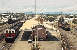
Casino railway station
Australian railway station
Distance: Approx. 960 meters
Latitude and longitude: -28.861081,153.038215
Casino railway station is a heritage-listed railway station on the North Coast line in New South Wales, Australia. Opening on 22 September 1930, it serves the town of Casino. It was added to the New South Wales State Heritage Register on 2 April 1999.
St. Mary's Catholic College, Casino
Private, coeducational school in Casino, New South Wales, Australia
Distance: Approx. 469 meters
Latitude and longitude: -28.8618,153.045
St. Mary's Catholic College Casino is a co-educational Catholic secondary school in Casino, New South Wales, Australia. It was founded by the Marist Brothers in 1946.
Casino Post Office
Historic site in New South Wales, Australia
Distance: Approx. 681 meters
Latitude and longitude: -28.8643,153.04704
Casino Post Office is a heritage-listed post office at 102 Barker Street, Casino, in the Northern Rivers region of New South Wales, Australia. It was designed by the NSW Colonial Architect's Office and built from 1879. The property is owned by Australia Post.
Old Casino railway station
Former railway station in Casino, Australia
Distance: Approx. 417 meters
Latitude and longitude: -28.8553,153.0502
Old Casino railway station is a heritage-listed former railway station and now museum on the Murwillumbah railway line at Casino, Richmond Valley Council, New South Wales, Australia. It was built from 1903. The property was added to the New South Wales State Heritage Register on 2 April 1999.
Camp Victory (New South Wales)
Royal Netherlands East Indies Army base during World War II in Australia
Distance: Approx. 3251 meters
Latitude and longitude: -28.8347,153.0277
Camp Victory, also known as Camp Casino, was a Royal Netherlands East Indies Army (KNIL) base and prisoner of war camp, used during World War II, near Casino, New South Wales, Australia. The Dutch government-in-exile was given extraterritorial rights over the management and conduct of the base. It was named Camp Victory by the Dutch government in the hopes of a swift recapture of the Dutch East Indies.
Weather in this IP's area
clear sky
18 Celsius
18 Celsius
18 Celsius
18 Celsius
1013 hPa
69 %
1013 hPa
1007 hPa
10000 meters
1.45 m/s
4.44 m/s
246 degree