Country:
 Pakistan
Region:
City:
Latitude and Longitude:
Time Zone:
Postal Code:
IP information under different IP Channel
ip-api
Country
Region
City
ASN
Time Zone
ISP
Blacklist
Proxy
Latitude
Longitude
Postal
Route
IPinfo
Country
Region
City
ASN
Time Zone
ISP
Blacklist
Proxy
Latitude
Longitude
Postal
Route
MaxMind
Country
Region
City
ASN
Time Zone
ISP
Blacklist
Proxy
Latitude
Longitude
Postal
Route
Luminati
Country
PKASN
Time Zone
Asia/Karachi
ISP
Pak-Qatar General Takaful Limited
Latitude
Longitude
Postal
db-ip
Country
Region
City
ASN
Time Zone
ISP
Blacklist
Proxy
Latitude
Longitude
Postal
Route
ipdata
Country
Region
City
ASN
Time Zone
ISP
Blacklist
Proxy
Latitude
Longitude
Postal
Route
Popular places and events near this IP address
Mohammad Ali Jinnah University
University in Karachi, Pakistan
Distance: Approx. 374 meters
Latitude and longitude: 24.8602,67.0699
The Mohammad Ali Jinnah University (Urdu: جامعہ محمد علی جناح), abbreviated as MAJU) is a private university located in Karachi, Sindh, Pakistan. Established in 1998, the university offers undergraduate and post-graduate programs with a strong emphasis on business management, applied sciences, engineering and computer science.
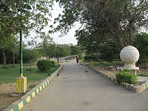
Hill Park, Karachi
Urban park in Pakistan
Distance: Approx. 547 meters
Latitude and longitude: 24.86722222,67.07111111
Hill Park (Urdu: باغ کوہ) is situated on a hilltop surrounded by a residential area known as PECHS neighborhood of Jamshed Town in Karachi, Sindh, Pakistan. The park is spread over 62 acres (25 ha) and of this only 25% area has been developed as park.
Azam Basti
Residential neighborhood of Karachi, Pakistan
Distance: Approx. 1515 meters
Latitude and longitude: 24.85,67.06666667
Azam Basti (Urdu: اعظم بستی) is a neighborhood in Karachi East district of Karachi, Pakistan. It was previously administered as part of Jamshed Town, which was disbanded in 2011. There are several ethnic groups in Azam Basti including Muhajirs, Punjabis, Sindhis, Kashmiris, Seraikis, Pakhtuns, Balochis, Memons, Bohras, Ismailis.

P.E.C.H.S Block 2
Neighbourhood in Karachi, Karachi East
Distance: Approx. 1376 meters
Latitude and longitude: 24.8694,67.0613
Pakistan Employees Cooperative Housing Society (PECHS), Block 2 (biggest block of PECHS) is a neighborhood in Karachi East district of Karachi, Pakistan. It was founded by Mehmood Ahmad Nizami in the year 1950, three years after Pakistan was founded by Quaid-e-Azam Mohammad Ali Jinnah. Mehmood Ahmad Nizami lived in this same society and also created the first house in PECHS where some of his descendants now live.
Bahadurabad
Neighbourhood of Karachi, Pakistan
Distance: Approx. 2395 meters
Latitude and longitude: 24.88333333,67.06666667
Bahadurabad (Urdu: بہادر آباد) is one of the neighbourhoods of Gulshan Town, Karachi, Sindh, Pakistan. It is located in the Civic Centre zone in the Gulshan Town. It was originally inhabited by mainly middle class Hyderabadi Muslim refugees from Hyderabad Deccan (now Hyderabad, Telangana, India) who migrated after the creation of Pakistan in 1947 and mainly after Hyderabad became part of India in 1948.

Jheel Park
Park in Karachi, Pakistan
Distance: Approx. 1279 meters
Latitude and longitude: 24.8702,67.0632
The Jheel Park or Society Jheel Park (Urdu: جھیل پارک یا سوسائٹی جھیل پارک ), is situated near Tariq Road in P.E.C.H Society, Karachi, Sindh, Pakistan. The park is constructed on 25 acres (100,000 m2) of land.
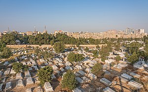
Gora Qabaristan, Karachi
Christian cemetery in Pakistan
Distance: Approx. 2418 meters
Latitude and longitude: 24.8556,67.0499
The Gora Qabaristan (Urdu: گورا قبرِستان; also spelled as Gora Kabristan), or Gora Cemetery, literally transliterated as White (man's) graveyard is Karachi, Pakistan's only operational Christian cemetery.
Jinnah Medical and Dental College
College in Karachi, Pakistan
Distance: Approx. 2285 meters
Latitude and longitude: 24.88111111,67.06305556
Jinnah Medical and Dental College (Sindhi: جناح ميڊيڪل ۽ ڊينٽل ڪالج or JMDC) was established in 1998 in Karachi, Sindh Pakistan. It is located in the heart of Karachi on Shaheed-e-Millat Road. The first batch of doctors and dentists graduated from JMDC in 2003 and 2004 whereas first batch of pharmacy graduated in 2009.
Tabani's School of Accountancy
Distance: Approx. 1406 meters
Latitude and longitude: 24.863436,67.058722
Tabani's School of Accountancy (Urdu: تابانی اسکول آف اکاؤنٹنسی, abbreviated as: TSA) is a privately owned tertiary institution which provides professional chartered accountancy education in Karachi, Pakistan. The school has three campuses throughout Karachi, with over 4,000 students studying at three differentiated campuses located at P.E.C.H.S, North Nazimabad and Clifton.
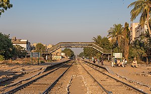
Chanesar railway station
Railway station in Pakistan
Distance: Approx. 802 meters
Latitude and longitude: 24.8573,67.0671
Chanesar Halt railway station (Urdu: چینیسر ریلوے اسٹیشن, Sindhi: چنيسر ريلوي اسٽيشن), is an abandoned train station located in Karachi, Pakistan, near the village of Chanesar Goth.

Nasla Tower
Residential building in Karachi
Distance: Approx. 1453 meters
Latitude and longitude: 24.860266,67.058425
Nasla Tower (نسلہ ٹاور) was a seventeen storey building located on Shahrah-e-Faisal, Karachi. In the encroachment case pending in the Supreme Court of Pakistan, the Supreme Court has ordered immediate demolition of Nasla Tower, a residential project in Plot No. 193 Sindhi Muslim Housing Society at the confluence of Shahra-e-Qaedin and Shahra-e-Faisal.

Kidney Hill Park
Park in Karachi, Pakistan
Distance: Approx. 2070 meters
Latitude and longitude: 24.88055556,67.0775
Kidney Hill Park, also known as Ahmed Ali Park, is an urban park located in Karachi, Pakistan. The park is known for its kidney-shaped hilly terrain and is considered one of the highest points in Karachi.
Weather in this IP's area
few clouds
28 Celsius
31 Celsius
28 Celsius
28 Celsius
1012 hPa
74 %
1012 hPa
1010 hPa
6000 meters
2.06 m/s
260 degree
20 %
06:25:40
18:13:39