Country:
 Australia
Region:
City:
Latitude and Longitude:
Time Zone:
Postal Code:
IP information under different IP Channel
ip-api
Country
Region
City
ASN
Time Zone
ISP
Blacklist
Proxy
Latitude
Longitude
Postal
Route
IPinfo
Country
Region
City
ASN
Time Zone
ISP
Blacklist
Proxy
Latitude
Longitude
Postal
Route
MaxMind
Country
Region
City
ASN
Time Zone
ISP
Blacklist
Proxy
Latitude
Longitude
Postal
Route
Luminati
Country
AURegion
qld
City
brisbane
ASN
Time Zone
Australia/Brisbane
ISP
Shine Corporate Ltd
Latitude
Longitude
Postal
db-ip
Country
Region
City
ASN
Time Zone
ISP
Blacklist
Proxy
Latitude
Longitude
Postal
Route
ipdata
Country
Region
City
ASN
Time Zone
ISP
Blacklist
Proxy
Latitude
Longitude
Postal
Route
Popular places and events near this IP address
Redbank Plains State High School
School in Redbank Plains, Queensland, Australia
Distance: Approx. 2306 meters
Latitude and longitude: -27.65204444,152.86908889
Redbank Plains State High School is a Secondary school located in Redbank Plains, Queensland, Australia.

Springfield Anglican College
School in Australia
Distance: Approx. 2129 meters
Latitude and longitude: -27.67055556,152.90777778
The Springfield Anglican College (TSAC) is an independent Anglican co-educational early learning, primary and secondary day school, located in Springfield, a suburb of the City of Ipswich in South East Queensland, Australia. The College comprises two campuses, the early learning centre and primary school from Kindergarten to Year 6, located on Springfield College Drive; and the secondary school from Year 7 to Year 12) on the Springfield – Greenbank Arterial. In 2024, the College has approximately 1100 students across both Campuses.
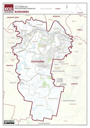
Electoral district of Bundamba
State electoral district of Queensland, Australia
Distance: Approx. 2631 meters
Latitude and longitude: -27.66666667,152.86666667
Bundamba is a Legislative Assembly of Queensland electoral division in the state of Queensland, Australia. The electorate encompasses suburbs in the east and south-east of the City of Ipswich local government area. Major locations include Bundamba, Blackstone, Goodna, Redbank Plains, Augustine Heights and Springfield.

Bellbird Park, Queensland
Suburb of Ipswich, Queensland, Australia
Distance: Approx. 2374 meters
Latitude and longitude: -27.6369,152.888
Bellbird Park is a suburb in the City of Ipswich, Queensland, Australia. In the 2021 census, Bellbird Park had a population of 9,191 people.

Augustine Heights, Queensland
Suburb of Ipswich, Queensland, Australia
Distance: Approx. 882 meters
Latitude and longitude: -27.6605,152.883
Augustine Heights is a suburb in the City of Ipswich, Queensland, Australia. In the 2021 census, Augustine Heights had a population of 6,088 people.

Brookwater, Queensland
Suburb of Ipswich, Queensland, Australia
Distance: Approx. 570 meters
Latitude and longitude: -27.6588,152.8972
Brookwater is a suburb in the City of Ipswich, Queensland, Australia. It is one of the suburbs of the Greater Springfield Development. In the 2021 census, Brookwater had a population of 2,902 people.

Springfield Central railway station
Railway station in Queensland, Australia
Distance: Approx. 2135 meters
Latitude and longitude: -27.6743,152.9029
Springfield Central Railway Station is the terminus station of the Springfield Line in Queensland, Australia. It serves Springfield Central (the central suburb of Greater Springfield) and other nearby suburbs in the City of Ipswich. Brisbane-bound services depart half-hourly during off-peak times, with most travelling to Kippa-Ring.

Springfield railway station, Ipswich
Railway station in Queensland, Australia
Distance: Approx. 3011 meters
Latitude and longitude: -27.66,152.92194444
Springfield railway station is located on the Springfield line in Queensland, Australia. It serves the Ipswich suburbs of Springfield and Springfield Lakes via footbridge access. It is the second-last station on the Springfield Line in the outbound direction.

Springfield Central, Queensland
Suburb of City of Ipswich, Queensland, Australia
Distance: Approx. 3304 meters
Latitude and longitude: -27.6855,152.9041
Springfield Central is a suburb in the City of Ipswich, Queensland, Australia. In the 2021 census, Springfield Central had a population of 234 people. It is the designated business district of Greater Springfield.
Woodcrest State College
Public, college in Springfield, Queensland, Australia
Distance: Approx. 2811 meters
Latitude and longitude: -27.658,152.92
Woodcrest State College is a co-educational public Prep to Year 12 school located in the City of Ipswich suburb of Springfield in Queensland, Australia. The school has a total enrolment of 1,719 students in 2022. Between 1998 and 2022, Pat Murphy was the Executive Principal of Woodcrest State College.

Springfield Central Stadium
Australian rules football stadium in Ipswich, Queensland, Australia
Distance: Approx. 2015 meters
Latitude and longitude: -27.67213889,152.90425
Springfield Central Stadium (also known due to naming rights sponsorship as Brighton Homes Arena) is an Australian rules football venue located in Springfield, a suburb of Ipswich, approximately 30 km south-west of Brisbane. The facility has been the permanent training and administrative home of professional Australian Football League (AFL) club the Brisbane Lions since 2022. The venue plays host to the club's AFL pre-season home practice matches as well as matches for the AFL Women's (AFLW), Victorian Football League (VFL) and the club's men's and women's Academy (junior) squad programs.

Woogaroo Forest
Forest in Queensland, Australia
Distance: Approx. 2431 meters
Latitude and longitude: -27.6375,152.9
Woogaroo Forest (also known as Woogaroo Scrub or Goodna Scrub) is an area of forest covered land in eastern Ipswich, Queensland, Australia. Woogaroo Forest currently covers over 450 hectares. Although not officially designated as protected bushland, it has been known locally for many years.
Weather in this IP's area
light rain
16 Celsius
17 Celsius
16 Celsius
18 Celsius
1018 hPa
95 %
1018 hPa
1012 hPa
10000 meters
1.54 m/s
290 degree
100 %
05:17:31
17:53:05