Country:
Region:
City:
Latitude and Longitude:
Time Zone:
Postal Code:
IP information under different IP Channel
ip-api
Country
Region
City
ASN
Time Zone
ISP
Blacklist
Proxy
Latitude
Longitude
Postal
Route
Luminati
Country
ASN
Time Zone
Asia/Hong_Kong
ISP
HGC Global Communications Limited
Latitude
Longitude
Postal
IPinfo
Country
Region
City
ASN
Time Zone
ISP
Blacklist
Proxy
Latitude
Longitude
Postal
Route
db-ip
Country
Region
City
ASN
Time Zone
ISP
Blacklist
Proxy
Latitude
Longitude
Postal
Route
ipdata
Country
Region
City
ASN
Time Zone
ISP
Blacklist
Proxy
Latitude
Longitude
Postal
Route
Popular places and events near this IP address

Causeway Bay station
MTR station on Hong Kong Island
Distance: Approx. 271 meters
Latitude and longitude: 22.2802,114.1835
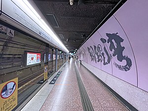
Causeway Bay (Chinese: 銅鑼灣; Cantonese Yale: Tùnglòwāan) is an underground metro station on the MTR network in Hong Kong. It is located between Wan Chai and Tin Hau stations on the Island line, and sits underneath Great George Street near Hennessy Road and Yee Wo Street. Named for the Causeway Bay area and its abundant shopping centres, the station serves various malls including Hysan Place, Sino Plaza, Sogo, and the nearby Victoria Park.

Times Square (Hong Kong)
Shopping centre in Causeway Bay, Hong Kong
Distance: Approx. 27 meters
Latitude and longitude: 22.27833333,114.18222222
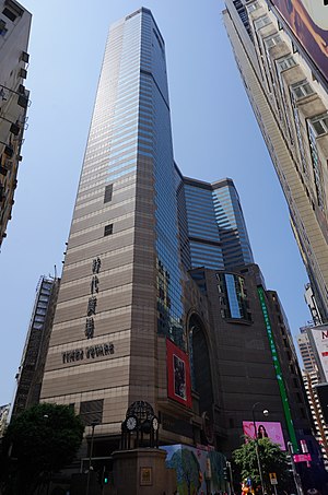
Times Square (Chinese: 時代廣場) is a luxury shopping centre and office tower complex in Causeway Bay, Hong Kong. The complex, owned by Wharf Properties, part of The Wharf (Holdings) Limited group, opened on 13 April 1994.

Canal Road, Hong Kong
Road in Hong Kong
Distance: Approx. 91 meters
Latitude and longitude: 22.27791,114.18117
Canal Road East (Chinese: 堅拿道東), Canal Road West (堅拿道西) and the Canal Road Flyover (堅拿道天橋) are important roads in the Wan Chai District of Hong Kong Island, between the areas of East Point near Causeway Bay, and Morrison Hill near Wan Chai.

Lee Theatre
Theatre in Hong Kong, China
Distance: Approx. 110 meters
Latitude and longitude: 22.27833333,114.18305556
Lee Theatre (Chinese: 利舞臺; Jyutping: lei6 mou5 toi4; pinyin: Lì wǔtái) was a prominent theatre in Causeway Bay on Hong Kong Island, Hong Kong. Once one of the premier performing venues in Hong Kong, the Beaux-Arts theatre was demolished in the 1990s and replaced with an office building and a shopping centre.
Percival Street
Street in Causeway Bay, Hong Kong
Distance: Approx. 182 meters
Latitude and longitude: 22.2797,114.1827
Percival Street is a street in the East Point and Happy Valley, Hong Kong Island, Hong Kong. The street spans from Gloucester Road in the north to Leighton Road in the south. Between Hennessy Road and Leighton Road, the street is with a branch of Hong Kong Tramways leading to Happy Valley.
Leighton Road
Road in Causeway Bay, Hong Kong
Distance: Approx. 226 meters
Latitude and longitude: 22.2776,114.1841
Leighton Road (Chinese: 禮頓道) is a main road in Causeway Bay, Hong Kong. It begins east of Causeway Road and ends at the west of the junction with Morrison Hill Road and Canal Road.

Lee Garden One
Hong Kong building complex
Distance: Approx. 269 meters
Latitude and longitude: 22.27833333,114.18461111
Manulife Plaza, also known as Lee Garden One, is an office skyscraper in Causeway Bay, Hong Kong Island, Hong Kong. The triangular-shaped tower stands 789 ft (240 m) tall and contains 52 floors of office space. The building is currently the 16th tallest in Hong Kong and the tallest in Causeway Bay.

Praya East Reclamation Scheme
Distance: Approx. 163 meters
Latitude and longitude: 22.2794,114.1811
Praya East Reclamation Scheme (Chinese: 海旁東填海計劃) was a large scale land reclamation project in Colonial Hong Kong lasting from 1921 to 1931 under Sir Catchick Paul Chater.

Russell Street, Hong Kong
Russell Streets in Hong Kong
Distance: Approx. 105 meters
Latitude and longitude: 22.27889,114.18269
Russell Street (Chinese: 羅素街) in Causeway Bay, Hong Kong Island, is a commercial shopping street in Hong Kong. In 2014, it was noted as the most expensive luxury street in the world. Russell Street is an east–west running street with two sections.
Brandon Learning Centre
Distance: Approx. 120 meters
Latitude and longitude: 22.27713889,114.18180556
The Brandon Learning Centre is the first school in Hong Kong to offer public speaking classes based around English Speaking Board assessments. The English Speaking Board was founded in 1954 and the qualifications are regulated by the UK Office of Qualifications and Examinations Regulation The school was founded in 2006, by Jessica Ogilvy-Stuart, PhD, and Andrew Cathcart, M.A., M.Ed, with the aim of developing confidence in spoken English and preparing students for overseas studies. The initial opening was supported by InvestHK and the school is regulated by the Education Bureau.

Hysan Place
Shopping centre in Causeway Bay, Hong Kong
Distance: Approx. 243 meters
Latitude and longitude: 22.2798,114.1836
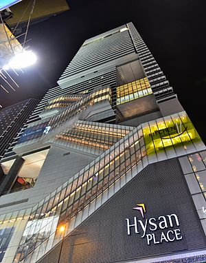
Hysan Place (Chinese: 希慎廣場; Jyutping: hei1 san6 gwong2 coeng4, sometimes 希慎, hei¹ san²*) is a shopping centre and office building at 500 Hennessy Road, Lee Garden, Causeway Bay, Hong Kong. It was developed by Hysan Development Company Limited at the former site of Hennessy Centre and was designed by international architecture firm Kohn Pedersen Fox. It was opened on 10 August 2012.
Tung Tak Pawn Shop
Demolished pawn shop in Hong Kong
Distance: Approx. 259 meters
Latitude and longitude: 22.27895,114.17962
Tung Tak Pawn Shop (Chinese: 同德押), also referred to as Nos. 369 & 371 Hennessy Road, is a former pawn shop and Grade III historic building in Wan Chai, Hong Kong. It was demolished in 2015.
Weather in this IP's area
overcast clouds
24 Celsius
25 Celsius
23 Celsius
25 Celsius
1018 hPa
65 %
1018 hPa
1013 hPa
10000 meters
4.47 m/s
40 degree
97 %
06:30:09
17:43:39


