Country:
 Bangladesh
Region:
City:
Latitude and Longitude:
Time Zone:
Postal Code:
IP information under different IP Channel
ip-api
Country
Region
City
ASN
Time Zone
ISP
Blacklist
Proxy
Latitude
Longitude
Postal
Route
IPinfo
Country
Region
City
ASN
Time Zone
ISP
Blacklist
Proxy
Latitude
Longitude
Postal
Route
MaxMind
Country
Region
City
ASN
Time Zone
ISP
Blacklist
Proxy
Latitude
Longitude
Postal
Route
Luminati
Country
BDASN
Time Zone
Asia/Dhaka
ISP
Apple Communication Ltd.
Latitude
Longitude
Postal
db-ip
Country
Region
City
ASN
Time Zone
ISP
Blacklist
Proxy
Latitude
Longitude
Postal
Route
ipdata
Country
Region
City
ASN
Time Zone
ISP
Blacklist
Proxy
Latitude
Longitude
Postal
Route
Popular places and events near this IP address

Ahsanullah University of Science and Technology
University in Dhaka, Bangladesh
Distance: Approx. 784 meters
Latitude and longitude: 23.76361111,90.40694444
Ahsanullah University of Science and Technology (Bengali: আহ্ছানউল্লা বিজ্ঞান ও প্রযুক্তি বিশ্ববিদ্যালয়), commonly known as AUST, is a private (science and technology) university in Bangladesh. It was founded by the Dhaka Ahsania Mission in 1995. Dhaka Ahsania Mission is a non-profit voluntary organization in Bangladesh.
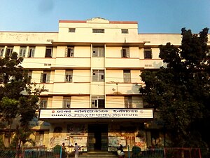
Dhaka Polytechnic Institute
College in Bangladesh
Distance: Approx. 479 meters
Latitude and longitude: 23.75888889,90.39972222
Dhaka Polytechnic Institute (Bengali: ঢাকা পলিটেকনিক ইনস্টিটিউট, also known as DPI) is a government technical institute in Dhaka, Bangladesh. It is the largest and the oldest polytechnic academia in modern Bangladesh.
Begun Bari
Human settlement in Bangladesh
Distance: Approx. 713 meters
Latitude and longitude: 23.763502,90.403683
Begunbari is a slum mahallah (neighborhood) in Ward 37 of Tejgaon Thana, Dhaka, Bangladesh. According to the 2011 Bangladesh census, it had 9,034 households and a population of 34,517.

Bangladesh University of Textiles
Public Research University, Bangladesh
Distance: Approx. 541 meters
Latitude and longitude: 23.7604,90.4001
Bangladesh University of Textiles, commonly referred to as BUTEX, is a public university in Bangladesh, situated in Tejgaon, Dhaka. It is the only public university in Bangladesh to teach textile engineering. The institution established education which sustains the entrepreneurship and industrialisation in the RMG industry of Bangladesh.
Ad-din Women's Medical College
Private medical college in Bangladesh
Distance: Approx. 965 meters
Latitude and longitude: 23.7485,90.4052
Ad-din Women's Medical College (AWMC) (Bengali: আদ-দ্বীন মহিলা মেডিকেল কলেজ) is a private medical college in Bangladesh, exclusively for female students, established in 2008. It is located in Maghbazar, Dhaka. It is affiliated with Dhaka University as a constituent college.

National Institute of Ear, Nose and Throat (Bangladesh)
Hospital in Tejgaon, Bangladesh
Distance: Approx. 707 meters
Latitude and longitude: 23.7633,90.4055
The National Institute of ENT (Ear, Nose and Throat) is a specialized hospital and training center in ear, nose and throat (Otorhinolaryngology) diseases located in Tejgaon, Dhaka, Bangladesh.

Tejgaon Industrial Area Thana
Thana in Dhaka Division, Bangladesh
Distance: Approx. 806 meters
Latitude and longitude: 23.76418,90.40566
Tejgaon Industrial Area Thana is a Thana of Dhaka District in the Division of Dhaka, Bangladesh that was formed in 2006.

Bangladesh Film Development Corporation
Distance: Approx. 793 meters
Latitude and longitude: 23.752593,90.3979781
Bangladesh Film Development Corporation (BFDC) is a government owned and operated corporation in Tejgaon, Dhaka, Bangladesh. Nuzhat Yeasmin is the managing director of the corporation.

BGMEA Bhaban
Building in Bangladesh
Distance: Approx. 972 meters
Latitude and longitude: 23.7508,90.3974
BGMEA Bhaban (BGMEA Building) was a 16-storey building that served as the former headquarters of Bangladesh Garment Manufacturers and Exporters Association and was located in Hatirjheel, Dhaka. The foundation of the building was placed in 1998 by then Prime Minister Sheikh Hasina. In 2006 it was inaugurated by then Prime Minister Khaleda Zia.

Moghbazar-Mouchak Flyover
Flyover in Bangladesh
Distance: Approx. 487 meters
Latitude and longitude: 23.7554,90.3996
The Moghbazar-Mouchak Flyover is the second largest flyover in Bangladesh. Its foundation stone was laid in 2011. The flyover was partially opened on 30 March 2016.
2021 Moghbazar explosion
Catastrophic Event in Bangladesh
Distance: Approx. 969 meters
Latitude and longitude: 23.7489,90.4072
The Moghbazar explosion took place on 27 June 2021 at the wireless gate of Moghbazar in Dhaka, the capital of Bangladesh. At least 7 people were killed and more than 100 injured, out of whom 66 were admitted to various hospitals. Police suspect the incident was caused by frozen gas.

Hatirjheel Thana
Thana in Dhaka
Distance: Approx. 845 meters
Latitude and longitude: 23.76,90.41166667
Hatirjheel Thana is a thana in Dhaka, the capital of Bangladesh. It was formed in 2018 with the Hatirjheel project and its surrounding areas. The areas under this thana were earlier under the thanas of Ramna, Tejgaon Industrial Area and Rampura .
Weather in this IP's area
haze
31 Celsius
38 Celsius
31 Celsius
31 Celsius
1005 hPa
74 %
1005 hPa
1004 hPa
5000 meters
3.09 m/s
140 degree
40 %
05:42:39
18:09:49