Country:
 Bangladesh
Region:
City:
Latitude and Longitude:
Time Zone:
Postal Code:
IP information under different IP Channel
ip-api
Country
Region
City
ASN
Time Zone
ISP
Blacklist
Proxy
Latitude
Longitude
Postal
Route
IPinfo
Country
Region
City
ASN
Time Zone
ISP
Blacklist
Proxy
Latitude
Longitude
Postal
Route
MaxMind
Country
Region
City
ASN
Time Zone
ISP
Blacklist
Proxy
Latitude
Longitude
Postal
Route
Luminati
Country
BDASN
Time Zone
Asia/Dhaka
ISP
New CNS Online
Latitude
Longitude
Postal
db-ip
Country
Region
City
ASN
Time Zone
ISP
Blacklist
Proxy
Latitude
Longitude
Postal
Route
ipdata
Country
Region
City
ASN
Time Zone
ISP
Blacklist
Proxy
Latitude
Longitude
Postal
Route
Popular places and events near this IP address
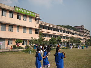
Azimpur Government Girls' School and College
Government school and college in Bangladesh
Distance: Approx. 559 meters
Latitude and longitude: 23.725,90.387
Azimpur Government Girls' School and College (Bengali: আজিমপুর গভর্নমেন্ট গার্লস স্কুল এন্ড কলেজ) is a secondary and higher secondary school in Azimpur, Dhaka, Bangladesh. It was established in 1957 by the Welfare Association of Government Employees. In 1999 the school had an enrollment of some 2,700 students and a faculty of 82.

Eden Mohila College
Women's college in Bangladesh
Distance: Approx. 239 meters
Latitude and longitude: 23.727842,90.3863622
Eden Mohila College (known as Eden College), is a women's college in Azimpur, Dhaka, Bangladesh. It was established in 1873 in the Farashganj area of Dhaka. In 1878 the school was named after Ashley Eden, Lieutenant Governor of Bengal.

Nilkhet
Distance: Approx. 446 meters
Latitude and longitude: 23.73333333,90.38333333
Nilkhet (Bengali: নীলক্ষেত) is a neighbourhood in Dhaka, the capital city of Bangladesh. It is located between Dhaka University to the east, Mirpur Road and New Market to the west, and Elephant Road to the north. The name Nilkhet (nil: blue or indigo, khet: field) implies that the area may have been used for indigo cultivation in earlier times.

New Market, Dhaka
Distance: Approx. 419 meters
Latitude and longitude: 23.7333,90.3839
New Market (Bengali: নিউ মার্কেট) is the largest commercial shopping market in Bangladesh in north of Azimpur, Dhaka. It is situated on the opposite side of Chandni Chowk.
Azimpur, Dhaka
Town in Dhaka Division, Bangladesh
Distance: Approx. 46 meters
Latitude and longitude: 23.73,90.385
Azimpur (Bengali: আজিমপুর) is an old region in the old part of Dhaka, capital of Bangladesh. The region is named after 7th Mughal Emperor Azam Shah who was the youngest son and successor of Mughal Emperor Aurangzeb. Other accounts attribute the name to Azim-us-Shaan, the Nayeb-e-Nazim of Dhaka during the early 18th century.

Agrani School and College
School in Bangladesh
Distance: Approx. 213 meters
Latitude and longitude: 23.729,90.3835
Agrani School and College was established at Azimpur, Dhaka, Bangladesh, in 1957 as a kindergarten. From the inception, the medium of instruction was English, although vernacular was also taught in all classes. It was upgraded into a secondary school for girls in 1967.

Salimullah Muslim Hall
Dorm hall at the University of Dhaka
Distance: Approx. 542 meters
Latitude and longitude: 23.7294,90.3907
Salimullah Muslim Hall is a residential hall at Dhaka University, named after Nawab Sir Khwaja Salimullah Bahadur. Inaugurated on 11 August 1931. Among the residential halls of Dhaka University, Salimullah Muslim Hall holds a special status due to its heritage.
Institute of Social Welfare and Research (Dhaka University)
Research institute in Bangladesh
Distance: Approx. 537 meters
Latitude and longitude: 23.7318,90.3806
Institute of Social Welfare and Research is one of the oldest institutes of the University of Dhaka. It is the apex institution for the social work education in Bangladesh. It offers Graduation, Post-Graduation, M.Phil.
New Paltan
Distance: Approx. 513 meters
Latitude and longitude: 23.7284,90.3806
New Paltan (Azimpur Natun Paltan in Dhaka City Corporation records) is near Dhaka's New Market in Azimpur. Several markets and a number of educational institutions (Dhaka University's Institute of Social Welfare and Research and arts faculty, Dhaka College, Government Laboratory High School, Dhaka City College and Eden Mohila College) are nearby. Border Guards Bangladesh headquarters is in neighbouring Pilkhana.

Government College of Applied Human Science
Distance: Approx. 162 meters
Latitude and longitude: 23.731,90.3863
Government College of Applied Human Science is a government college formerly known as the College of Home Economics.

Chandni Chowk, Dhaka
Distance: Approx. 477 meters
Latitude and longitude: 23.7340593,90.3848641
Chandni Chowk (Bengali: চাঁদনি চক) or Chandni Chowk Shopping Complex is one of markets in Dhaka, Bangladesh. It is situated in Mirpur Road, near to New Market. This market area is under New Market Thana.

Balaka Cineworld
Movie theater in Bangladesh
Distance: Approx. 402 meters
Latitude and longitude: 23.7334,90.3851
Balaka is a movie theater located in New Market, Dhaka, Bangladesh. Balaka Cineworld, one of the oldest movie theaters in the country, was closed on 20 March 2020 for COVID-19 epidemic, but reopened on 29 September 2022.
Weather in this IP's area
haze
29 Celsius
35 Celsius
29 Celsius
29 Celsius
1008 hPa
79 %
1008 hPa
1006 hPa
3200 meters
2.57 m/s
50 degree
75 %
05:56:56
17:29:55