Country:
Region:
City:
Latitude and Longitude:
Time Zone:
Postal Code:
IP information under different IP Channel
ip-api
Country
Region
City
ASN
Time Zone
ISP
Blacklist
Proxy
Latitude
Longitude
Postal
Route
Luminati
Country
Region
yo
City
yogyakarta
ASN
Time Zone
Asia/Jakarta
ISP
Dinas Komunikasi dan Informatika
Latitude
Longitude
Postal
IPinfo
Country
Region
City
ASN
Time Zone
ISP
Blacklist
Proxy
Latitude
Longitude
Postal
Route
db-ip
Country
Region
City
ASN
Time Zone
ISP
Blacklist
Proxy
Latitude
Longitude
Postal
Route
ipdata
Country
Region
City
ASN
Time Zone
ISP
Blacklist
Proxy
Latitude
Longitude
Postal
Route
Popular places and events near this IP address

Bethesda Hospital (Yogyakarta)
Hospital in Special Region of Yogyakarta, Indonesia
Distance: Approx. 1610 meters
Latitude and longitude: -7.783,110.378
Bethesda Hospital (Rumah Sakit Bethesda), founded in 1899, is the oldest hospital in Yogyakarta, Indonesia. It is managed by Yayasan Kristen untuk Kesehatan Umum (Yakkum, lit. 'Christian Foundation for General Health').

Mandala Krida Stadium
Sporting venue in Yogyakarta, Indonesia
Distance: Approx. 32 meters
Latitude and longitude: -7.79583333,110.38416667
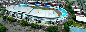
Mandala Krida Stadium (Indonesian: Stadion Mandala Krida; Javanese: ꦱꦼꦠꦝꦶꦪꦺꦴꦤ꧀ꦩꦤ꧀ꦢꦭꦏꦿꦶꦢ, romanized: Setadhiyon Mandala Krida) is a football stadium located in Yogyakarta, Yogyakarta Special Region, Indonesia. The stadium is surrounded by three roads, east is the Gondosuli Road, south is Kenari Road, and west is the Andung Road. The stadium is used mostly for football matches in general and also held several large events in the city, such as concerts, the presidential campaign, and Eid prayers.
Duta Wacana Christian University
Private university in Yogyakarta, Indonesia
Distance: Approx. 1331 meters
Latitude and longitude: -7.78583333,110.37805556
Duta Wacana Christian University (DWCU) or Universitas Kristen Duta Wacana (UKDW) is a private university in Yogyakarta, central of Java island, Indonesia. "Duta Wacana" in Sanskrit conveys an approximate meaning of being 'an ambassador for knowledge' or 'a messenger of the word'. According to Webometrics World Universities' Ranking on the Web 2007, DWCU is ranked at 89th place among Southeast Asian universities.

Lempuyangan railway station
Railway station in Indonesia
Distance: Approx. 1180 meters
Latitude and longitude: -7.7901989,110.3754443
Lempuyangan Station (Javanese: ꦱꦼꦠꦱꦶꦪꦸꦤ꧀ꦊꦩ꧀ꦥꦸꦪꦔꦤ꧀, romanized: Setasiyun Lempuyangan; LPN) is a railway station located in Bausasran, Danurejan, Yogyakarta, Indonesia. It is 1 kilometre (0.62 mi) east of Yogyakarta Station, 114 metres (374 ft) above sea level. The station is part of Operational Area VI Yogyakarta.
Kusumanegara Heroes' Cemetery
Cemetery in Indonesia
Distance: Approx. 750 meters
Latitude and longitude: -7.80269722,110.38363056
Kusumanegara Heroes' Cemetery (also spelled Kusuma Negara; also known as Semaki Heroes' Cemetery) is a cemetery located in Yogyakarta, Indonesia. It is the final resting place of five National Heroes of Indonesia.
University of Sarjanawiyata Tamansiswa in Yogyakarta
Distance: Approx. 1065 meters
Latitude and longitude: -7.8015,110.3923
Universitas Sarjanawiyata Tamansiswa Yogyakarta is a university in Yogyakarta City in Indonesia. The University has its origins in Taman Siswa founded in 1922 by Ki Hajar Dewantara.

Taman Pintar Yogyakarta
Science museum in Yogyakarta, Indonesia
Distance: Approx. 1932 meters
Latitude and longitude: -7.80055556,110.3675
Taman Pintar Yogyakarta (lit. 'Yogyakarta Smart Park'), or just Taman Pintar, is a science-themed park and museum for kids and a place for expression, appreciation, creation in a pleasant situation. It is situated on the center of the city of Yogyakarta, on Jalan Panembahan Senopati. Bringing its motto educate and pleasant, the place that was firstly built in 2004 wants to increase the intention of kids and the young generation in science through imaginations, trials, and games in order to improve the human resources.

Dharma Wiratama Museum
Military museum in Yogyakarta, Indonesia
Distance: Approx. 1759 meters
Latitude and longitude: -7.782883,110.3755
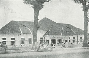
Dharma Wiratama Museum, officially the Dharma Wiratama Central Army Museum (Indonesian: Museum Pusat TNI AD Dharma Wiratama) is a military museum centred on the history of the Indonesian Army from its inception in 1945 up through the coup of 30 September 1965 and Indonesian peacekeeping missions. It is located in the former national army headquarters in Yogyakarta.
Bintaran
Distance: Approx. 1313 meters
Latitude and longitude: -7.805,110.3767
Bintaran (Javanese: ꦧꦶꦤ꧀ꦠꦫꦤ꧀) is a village in Wirogunan, Mergangsan, Yogyakarta, Indonesia. The area is known for its Dutch-Javanese architecture. It was formerly a Catholic settlement.

Gembira Loka Zoo
Zoo in Yogyakarta, Indonesia
Distance: Approx. 1731 meters
Latitude and longitude: -7.803968,110.3978733
Gembira Loka Zoo (Indonesian: Kebun Binatang Gembira Loka; Javanese: ꦏꦼꦧꦺꦴꦤ꧀ꦫꦗꦒꦼꦩ꧀ꦧꦶꦫꦭꦺꦴꦏ, romanized: Kêbon Raja Gêmbira Loka) is a zoological garden located in Yogyakarta, Special Region of Yogyakarta, Indonesia. Gembira Loka Zoo was opened in 1956 and comprises a botanical garden, orchid nursery, (artificial) lake, children's park, numerous scenic bridges across the Gajahwong River, and a collection of approximately 470 animals, most notable of which are its native Indonesian tigers, leopards, Komodo dragons, saltwater crocodiles, orangutans, and gibbons, as well as African animals such as lions, camels and hippopotamus. The park is 54 acres (21.8 hectares) in size.
De Britto High School Yogyakarta
Catholic high school in Yogyakarta, Indonesia
Distance: Approx. 1788 meters
Latitude and longitude: -7.78277778,110.39361111
De Britto College High School Yogyakarta ("JB" after John de Britto, a 17th-century Portuguese missionary to India) is a private Catholic all-boys high school run by the Indonesian Province of the Society of Jesus (Jesuits) in Yogyakarta, Indonesia. It was founded by the Jesuits on August 19, 1948, on an eight-acre (3.2 ha) campus.
Among Rogo Sports Hall
Multifunction sports arena in Special Region of Yogyakarta, Indonesia
Distance: Approx. 244 meters
Latitude and longitude: -7.79801001,110.38529013
Among Rogo Sports Hall (Indonesian: Gelanggang Olahraga Among Rogo) is a multifunction sports arena in Semaki, Umbulharjo, Yogyakarta, Special Region of Yogyakarta, Indonesia. This arena can be used for basketball, badminton, volleyball, futsal, and taekwondo venues.
Weather in this IP's area
light rain
27 Celsius
27 Celsius
27 Celsius
27 Celsius
1008 hPa
87 %
1008 hPa
995 hPa
10000 meters
1.05 m/s
2.21 m/s
218 degree
99 %
05:09:16
17:38:18

