103.82.138.160 - IP Lookup: Free IP Address Lookup, Postal Code Lookup, IP Location Lookup, IP ASN, Public IP
Country:
Region:
City:
Location:
Time Zone:
Postal Code:
IP information under different IP Channel
ip-api
Country
Region
City
ASN
Time Zone
ISP
Blacklist
Proxy
Latitude
Longitude
Postal
Route
Luminati
Country
ASN
Time Zone
Australia/Sydney
ISP
Summit Internet Australia
Latitude
Longitude
Postal
IPinfo
Country
Region
City
ASN
Time Zone
ISP
Blacklist
Proxy
Latitude
Longitude
Postal
Route
IP2Location
103.82.138.160Country
Region
queensland
City
the summit
Time Zone
Australia/Brisbane
ISP
Language
User-Agent
Latitude
Longitude
Postal
db-ip
Country
Region
City
ASN
Time Zone
ISP
Blacklist
Proxy
Latitude
Longitude
Postal
Route
ipdata
Country
Region
City
ASN
Time Zone
ISP
Blacklist
Proxy
Latitude
Longitude
Postal
Route
Popular places and events near this IP address

Thulimbah, Queensland
Town in Queensland, Australia
Distance: Approx. 3978 meters
Latitude and longitude: -28.5513,151.9486
Thulimbah is a rural town and locality in the Southern Downs Region, Queensland, Australia. In the 2021 census, the locality of Thulimbah had a population of 351 people. It borders New South Wales.
Applethorpe, Queensland
Town in Queensland, Australia
Distance: Approx. 3970 meters
Latitude and longitude: -28.6175,151.9552
Applethorpe is a rural town and locality in the Southern Downs Region, Queensland, Australia. It is on Queensland's border with New South Wales. It is well known for the production of apples.
Stanthorpe Airport
Airport in Queensland, Australia
Distance: Approx. 4516 meters
Latitude and longitude: -28.61833333,151.99
Stanthorpe Airport (IATA: SNH, ICAO: YSPE) is located at Applethorpe to the immediate north of Stanthorpe, Southern Downs Region, Queensland, Australia.
Stanthorpe Soldiers Memorial
Historic site in Queensland, Australia
Distance: Approx. 8496 meters
Latitude and longitude: -28.6561,151.9406
Stanthorpe Soldiers Memorial is a heritage-listed war memorial at Lock Street, Stanthorpe, Southern Downs Region, Queensland, Australia. It was designed by Dornbusch & Connolly and built from 1925 to 1926 by N J Thompson & Sons. It is also known as Stanthorpe War Memorial.

El Arish, Stanthorpe
Historic site in Queensland, Australia
Distance: Approx. 8494 meters
Latitude and longitude: -28.6558,151.9396
El Arish is a heritage-listed house and gardens at 94 Greenup Street, Stanthorpe, Southern Downs Region, Queensland, Australia. It was built from 1880s & early 1920s to 1930s. It was added to the Queensland Heritage Register on 4 October 1996.
Masel Residence
Historic site in Queensland, Australia
Distance: Approx. 8174 meters
Latitude and longitude: -28.6524,151.9384
Masel Residence is a heritage-listed detached house at 98 High Street, Stanthorpe, Southern Downs Region, Queensland, Australia. It was designed by Charles William Thomas Fulton and built from 1937 to 1938 by Kell & Rigby. It is also known as Diamond Residence.
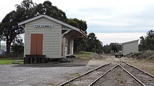
The Summit railway station
Former railway station in Queensland, Australia
Distance: Approx. 1937 meters
Latitude and longitude: -28.5746,151.949543
The Summit railway station is located on the Southern line in Queensland, Australia. It services the town of The Summit, a fruit growing district in the Granite Belt. At 923.5 metres (3,030 ft) above sea level, it is the highest station in the state.
The Summit, Queensland
Town in Queensland, Australia
Distance: Approx. 1780 meters
Latitude and longitude: -28.5755,151.9508
The Summit is a rural town and locality in the Southern Downs Region, Queensland, Australia. In the 2021 census, the locality of The Summit had a population of 436 people. The locality borders New South Wales.
Mount Marlay
Mountain in Queensland, Australia
Distance: Approx. 8032 meters
Latitude and longitude: -28.65333333,151.94694444
Mount Marlay is a mountain in the Southern Downs Region, Queensland, Australia.

Cottonvale, Queensland
Suburb of Southern Downs Region, Queensland, Australia
Distance: Approx. 7691 meters
Latitude and longitude: -28.5186,151.9391
Cottonvale is a rural locality in the Southern Downs Region, Queensland, Australia. It borders New South Wales and contains the town of Cotton Vale. In the 2021 census, Cottonvale had a population of 153 people.

Fleurbaix, Queensland
Suburb of Southern Downs Region, Queensland, Australia
Distance: Approx. 8079 meters
Latitude and longitude: -28.5277,151.9136
Fleurbaix is a locality in the Southern Downs Region, Queensland, Australia. In the 2021 census, Fleurbaix had a population of 56 people.

Glen Niven, Queensland
Suburb of Southern Downs Region, Queensland, Australia
Distance: Approx. 618 meters
Latitude and longitude: -28.5855,151.9725
Glen Niven is a rural locality in the Southern Downs Region, Queensland, Australia. It is within the Granite Belt on the Darling Downs and adjacent to the border with New South Wales. In the 2021 census, Glen Niven had a population of 99 people.
Weather in this IP's area
clear sky
19 Celsius
18 Celsius
19 Celsius
19 Celsius
1017 hPa
74 %
1017 hPa
916 hPa
10000 meters
5.16 m/s
10.64 m/s
98 degree
2 %


