Country:
 India
IndiaRegion:
City:
Latitude and Longitude:
Time Zone:
Postal Code:
IP information under different IP Channel
ip-api
Country
Region
City
ASN
Time Zone
ISP
Blacklist
Proxy
Latitude
Longitude
Postal
Route
IPinfo
Country
Region
City
ASN
Time Zone
ISP
Blacklist
Proxy
Latitude
Longitude
Postal
Route
MaxMind
Country
Region
City
ASN
Time Zone
ISP
Blacklist
Proxy
Latitude
Longitude
Postal
Route
Luminati
Country
INASN
Time Zone
Asia/Kolkata
ISP
Autonetic Software Technologies Pvt Ltd
Latitude
Longitude
Postal
db-ip
Country
Region
City
ASN
Time Zone
ISP
Blacklist
Proxy
Latitude
Longitude
Postal
Route
ipdata
Country
Region
City
ASN
Time Zone
ISP
Blacklist
Proxy
Latitude
Longitude
Postal
Route
Popular places and events near this IP address
Jawaharlal Nehru Technological University, Hyderabad
University in Hyderabad, Telangana, India
Distance: Approx. 1217 meters
Latitude and longitude: 17.49268,78.40539
Jawaharlal Nehru Technological University, Hyderabad (JNTU Hyderabad) is a public university, located in Hyderabad, Telangana. Founded in 1965 as the Nagarjuna Sagar Engineering College, it was established as a university in 1972 by The Jawaharlal Nehru Technological University Act, 1972. The university is situated at Kukatpally Housing Board Region in Hyderabad of India.

Kukatpally
Suburb in Medchal-Malkajgiri, Telangana, India
Distance: Approx. 2316 meters
Latitude and longitude: 17.48333333,78.41666667
Kukatpally is a suburb located in the northwestern part of Hyderabad in the Indian state of Telangana. It is the headquarters of Balanagar mandal in Malkajgiri revenue division of Medchal-Malkajgiri district. It was a municipality prior to its merger into the Greater Hyderabad Municipal Corporation (GHMC).

Sanathnagar
Neighbourhood in Hyderabad, Telangana, India
Distance: Approx. 2316 meters
Latitude and longitude: 17.48333333,78.41666667
Sanathnagar is an industrial and residential neighbourhood in Hyderabad City, Telangana, India, and one of the most densely populated neighbourhoods in India. In the past, a part of it served as a residential area for officers and workers in the industries located there. The residential area is known as SRT (Single Room Tenements) quarters.
Moosapet
Neighbourhood in Medchal-Malkajgiri district, Telangana, India
Distance: Approx. 2316 meters
Latitude and longitude: 17.48333333,78.41666667
Moosapet is a neighbourhood in Hyderabad, India, And also a part of Greater Hyderabad. The suburb is 3 km (1.9 mi) from KPHB Colony and 5 km (3.1 mi) from Madhapur. Kukatpally Y junction is located in this area.

Erragadda
Urban in Telangana, India
Distance: Approx. 2316 meters
Latitude and longitude: 17.48333333,78.41666667
Erragadda is a developing commercial and residential area in the west zone of Hyderabad, Telangana, India. It is home to the ECE Industries, an electrical enterprise. Popular landmarks are the Gokul theater and St.

Hi-Tech City railway station
Railway station in India
Distance: Approx. 2263 meters
Latitude and longitude: 17.4696,78.3852
Hi-Tech City railway station in Hyderabad, Telangana, India located on the Wadi–Hyderabad Deccan section of South Central Railway. Jawaharlal Nehru Technological University, Hyderabad and localities like Kukatpally, Madhapur and are accessible from this station. A modern railway terminal is proposed to be constructed near HITEC City railway station to facilitate passengers in the western parts of the city.
Allwyn Colony
Neighbourhood in Medchal, Telangana, India
Distance: Approx. 2316 meters
Latitude and longitude: 17.48333333,78.41666667
Allwyn Colony is a residential colony in Hyderabad, Telangana, India. It is located on the northwest fringe of Hyderabad city and is near to Kukatpally. Allwyn Colony is divided into two phases called 1st and 2nd phases.
Kondapur
Suburb in Ranga Reddy, Telangana, India
Distance: Approx. 2316 meters
Latitude and longitude: 17.48333333,78.41666667
Kondapur is a suburb in western part of Hyderabad, Telangana, India. It falls under Serilingampally mandal of Ranga Reddy district. The locality has emerged as a prominent commercial and residential hub, owing to its close proximity to IT corridor of Hyderabad.

Kukatpally Assembly constituency
Constituency of the Telangana legislative assembly in India
Distance: Approx. 608 meters
Latitude and longitude: 17.488,78.401
Kukatpally Assembly Constituency is a constituency of Telangana Legislative Assembly, India. It is one of 14 constituencies in Medchal-Malkajgiri district. It is part of Malkajgiri Lok Sabha constituency.
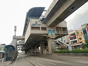
Kukatpally metro station
Metro station in Hyderabad, India
Distance: Approx. 1517 meters
Latitude and longitude: 17.4851155,78.409369
The Kukatpally Metro Station is located on the Red Line of the Hyderabad Metro in India. This station was opened to public on 2017. It is near to Reliance Smart Bazaar, BJP Office, Omni Hospital, Sri Chaitanya Junior College, TSRTC Bus Stop, Reliance Digital and Indian Post Office.
KPHB Colony metro station
Metro station in Hyderabad, India
Distance: Approx. 982 meters
Latitude and longitude: 17.49378,78.401795
The KPHB Colony Metro Station is located on the Red Line of the Hyderabad Metro in India. This station was opened to the public in 2017. It is near to Remedy Hospital, Chennai shopping mall, Usha Mullapudi arch, Vishwanath Theatre, TSRTC Bus stop, Apollo Hospital and KPHB Colony.

JNTU College metro station
Metro station in Hyderabad, India
Distance: Approx. 1421 meters
Latitude and longitude: 17.498653,78.388793
The JNTU College Metro Station is located on the Red Line of the Hyderabad Metro in India. This station was opened to the public in 2017. It is located near JNTU College.
Weather in this IP's area
light rain
30 Celsius
33 Celsius
30 Celsius
30 Celsius
1009 hPa
62 %
1009 hPa
946 hPa
6000 meters
2.57 m/s
40 degree
40 %
06:11:22
17:50:04