Country:
Region:
City:
Latitude and Longitude:
Time Zone:
Postal Code:
IP information under different IP Channel
ip-api
Country
Region
City
ASN
Time Zone
ISP
Blacklist
Proxy
Latitude
Longitude
Postal
Route
Luminati
Country
Region
tki
City
newplymouth
ASN
Time Zone
Pacific/Auckland
ISP
PrimoWireless Ltd
Latitude
Longitude
Postal
IPinfo
Country
Region
City
ASN
Time Zone
ISP
Blacklist
Proxy
Latitude
Longitude
Postal
Route
db-ip
Country
Region
City
ASN
Time Zone
ISP
Blacklist
Proxy
Latitude
Longitude
Postal
Route
ipdata
Country
Region
City
ASN
Time Zone
ISP
Blacklist
Proxy
Latitude
Longitude
Postal
Route
Popular places and events near this IP address

New Plymouth
City in Taranaki, New Zealand
Distance: Approx. 2062 meters
Latitude and longitude: -39.05777778,174.07416667
New Plymouth (Māori: Ngāmotu) is the major city of the Taranaki region on the west coast of the North Island of New Zealand. It is named after the English city of Plymouth, in Devon, from where the first English settlers to New Plymouth migrated. The New Plymouth District, which includes New Plymouth City and several smaller towns, is the 10th largest district (out of 67) in New Zealand, and has a population of 90,000 – about two-thirds of the total population of the Taranaki Region and 1.7% of New Zealand's population.

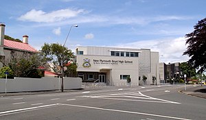
New Plymouth Boys' High School
School
Distance: Approx. 1837 meters
Latitude and longitude: -39.0613,174.0866
New Plymouth Boys' High School is a single-sex boys' state secondary school in New Plymouth, Taranaki, New Zealand. The school currently caters for approximately 1300 students, including 210 boarders, on its 15 hectares (37 acres) site. The school often collaborates with the very close-by New Plymouth Girls' High School.

Fitzroy, New Plymouth
Suburb of New Plymouth, New Zealand
Distance: Approx. 1132 meters
Latitude and longitude: -39.04694444,174.10472222
Fitzroy (Māori: Poutūtaki) is a coastal suburb of New Plymouth, in the western North Island of New Zealand. It is located to the north-east of the city centre. The area was initially named the Fitzroy Block after Governor Robert FitzRoy reduced the land purchased by the Plymouth Company from local Māori from 25,000 hectares (62,000 acres) to 1,500 hectares (3,700 acres) in the mid-1840s.

New Plymouth Girls' High School
School
Distance: Approx. 1205 meters
Latitude and longitude: -39.0559,174.0946
New Plymouth Girls' High School is a girls' state secondary school in Strandon, New Plymouth, New Zealand. The school separated from New Plymouth High School in 1914, leaving New Plymouth Boys' High School on the old site. It is currently one of two of New Plymouth's girls' schools along with Sacred Heart Girls' College and has a current roll of 1329 students.
Sacred Heart Girls' College, New Plymouth
School
Distance: Approx. 1252 meters
Latitude and longitude: -39.0527,174.1027
Sacred Heart Girls' College is a single-sex (girls) secondary and intermediate school in New Plymouth, New Zealand. Sacred Heart started as a school and boarding facility called Sacred Heart College, founded by the Sisters of Our Lady of the Missions in 1884. The school was next to the present St Joseph's Church and catered for primary & secondary students.

Waiwhakaiho River
River in New Zealand
Distance: Approx. 1621 meters
Latitude and longitude: -39.0371,174.1073
The Waiwhakaiho River is a river of the Taranaki Region of New Zealand's North Island. One of many rivers and streams radiating from the slopes of Taranaki/Mount Egmont, it flows initially northeast before veering northwest to reach the Tasman Sea close to the New Plymouth suburb of Fitzroy. Near the sea, it is crossed by the coastal walkway, connecting New Plymouth with Bell Block via the Te Rewa Rewa Bridge.

Wind Wand
Kinetic sculpture in New Plymouth, New Zealand
Distance: Approx. 2108 meters
Latitude and longitude: -39.056056,174.071736
The Wind Wand is a 48-metre kinetic sculpture located in New Plymouth, New Zealand. The sculpture includes a 45-metre tube of red fibreglass, and was made to designs by artist Len Lye. To residents, it is one of the main icons of New Plymouth.

Te Rewa Rewa Bridge
Bridge across the Waiwhakaiho River in New Plymouth, New Zealand
Distance: Approx. 1932 meters
Latitude and longitude: -39.037778,174.111944
Te Rewa Rewa Bridge is a pedestrian and cycleway bridge across the Waiwhakaiho River at New Plymouth in New Zealand. Its spectacular shape and setting make it a popular landmark.

Te Henui Cemetery
Cemetery in New Plymouth, New Zealand
Distance: Approx. 1303 meters
Latitude and longitude: -39.057,174.092
Te Henui Cemetery, also known as New Plymouth Cemetery, is the oldest public cemetery in New Plymouth, New Zealand. It was first used in 1861. The New Zealand Ministry for Culture and Heritage gives a translation of "the great mistake" for Te Hēnui.
East End, New Zealand
Distance: Approx. 425 meters
Latitude and longitude: -39.049,174.093
East End is a coastal suburb of New Plymouth, in the western North Island of New Zealand. It is located to the east of the city centre, north of Strandon, and west of Fitzroy. One of New Plymouth's main roads, Devon Street East, forms an approximate southern boundary of the suburb.

Holy Trinity Church, New Plymouth
Heritage church in New Plymouth, New Zealand
Distance: Approx. 750 meters
Latitude and longitude: -39.049436,174.098652
Holy Trinity Church is a heritage-listed Anglican building at 12 Henui Street, Fitzroy, New Plymouth, New Zealand. The church is one of the heritage buildings registered by Heritage New Zealand as a Category 1 Historic Place located in New Plymouth. It is one of the few remaining church buildings that had their foundations in the earliest period of European settlement.

Strandon
Suburb of New Plymouth, New Zealand
Distance: Approx. 987 meters
Latitude and longitude: -39.054,174.094
Strandon is a suburb of New Plymouth, in the western North Island of New Zealand. It is located to the east of the city centre.
Weather in this IP's area
overcast clouds
13 Celsius
13 Celsius
13 Celsius
15 Celsius
1021 hPa
100 %
1021 hPa
1021 hPa
10000 meters
1.05 m/s
1.45 m/s
216 degree
100 %
06:09:01
20:05:30