Country:
Region:
City:
Latitude and Longitude:
Time Zone:
Postal Code:
IP information under different IP Channel
ip-api
Country
Region
City
ASN
Time Zone
ISP
Blacklist
Proxy
Latitude
Longitude
Postal
Route
Luminati
Country
Region
tki
City
newplymouth
ASN
Time Zone
Pacific/Auckland
ISP
PrimoWireless Ltd
Latitude
Longitude
Postal
IPinfo
Country
Region
City
ASN
Time Zone
ISP
Blacklist
Proxy
Latitude
Longitude
Postal
Route
db-ip
Country
Region
City
ASN
Time Zone
ISP
Blacklist
Proxy
Latitude
Longitude
Postal
Route
ipdata
Country
Region
City
ASN
Time Zone
ISP
Blacklist
Proxy
Latitude
Longitude
Postal
Route
Popular places and events near this IP address

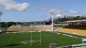
Yarrow Stadium
New Zealand rugby stadium
Distance: Approx. 22 meters
Latitude and longitude: -39.07027778,174.065
Yarrow Stadium is situated in the central suburb of Westown in New Plymouth, Taranaki, New Zealand, with main vehicle access off Maratahu Street. Named the third best rugby stadium on earth by New Zealand Rugby World magazine in May 2009, Yarrow Stadium (known as Stadium Taranaki for the Rugby World Cup 2011) conforms with the International Rugby Board's "clean stadium" policy. The primary tenant of this 25,000-capacity stadium is the Taranaki Rugby Football Union which has a representative team playing in the country's principal rugby union competition, the Mitre 10 Cup.

New Plymouth Observatory
Observatory
Distance: Approx. 1129 meters
Latitude and longitude: -39.0627,174.0737
New Plymouth Observatory was opened in 1920 and is situated on Marsland Hill, Robe Street, New Plymouth, New Zealand, and is the home of the New Plymouth Astronomical Society (NPAS). The Society opens the Observatory to the Public, Tuesday evenings. Winter hours are 7.30-9.00pm.

Westown
Suburb of New Plymouth, New Zealand
Distance: Approx. 859 meters
Latitude and longitude: -39.075,174.05722222
Westown is a suburb of New Plymouth, in the western North Island of New Zealand. It is located to the southwest of the city centre and west of Frankleigh Park. Taranaki Base Hospital lies between Westown and Lynmouth.

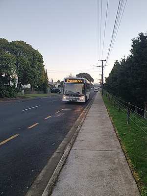
Frankleigh Park
Suburb of New Plymouth, New Zealand
Distance: Approx. 1127 meters
Latitude and longitude: -39.07972222,174.07027778
Frankleigh Park is a suburb of New Plymouth, in the western North Island of New Zealand. It is located to the south of the city centre. The suburb is built around the site of early settler Henry King's farm, Woodleigh, the father of William Cutfield King.
Lynmouth, New Zealand
Suburb of New Plymouth, New Zealand
Distance: Approx. 1181 meters
Latitude and longitude: -39.06444444,174.05388889
Lynmouth is a suburb of New Plymouth in the Taranaki Region of New Zealand. It is located to the west of the city centre. Taranaki Base Hospital is between Lynmouth and Westown to the south.

Brooklands, New Plymouth
Suburb in New Plymouth, New Zealand
Distance: Approx. 1280 meters
Latitude and longitude: -39.07,174.08
Brooklands is a suburb of New Plymouth, in the Taranaki region of the western North Island of New Zealand. It is located on the southern edge of the city and east of Vogeltown. The area is named after Brooklands farm, established in 1842.

Govett-Brewster Art Gallery
Art museum in New Plymouth, New Zealand
Distance: Approx. 1369 meters
Latitude and longitude: -39.05861111,174.06972222
The Govett-Brewster Art Gallery is a contemporary art museum at New Plymouth, Taranaki, New Zealand. The gallery receives core funding from the New Plymouth District Council. Govett-Brewster is recognised internationally for contemporary art.

Festival of Lights (New Plymouth)
Distance: Approx. 1398 meters
Latitude and longitude: -39.06444444,174.07944444
The TSB Festival of Lights is an annual event held in Pukekura Park, New Plymouth. Running for free every year from mid-December to late January, it has a daytime and night time programme of events for people of all ages, with light installations illuminating the park. In 2021 the festival won the Best Local Government and NZ's Favourite Event Awards at the 2021 NZ Events Association Awards.
Radio Taranaki
Radio station in New Plymouth
Distance: Approx. 1310 meters
Latitude and longitude: -39.0597034,174.0715209
Radio Taranaki was a radio station in New Plymouth and Hāwera. The station was originally started by Radio New Zealand (which at the time was known as the National Broadcasting Service) in 1948 as 2XP which broadcast on 1370AM in New Plymouth. The callsign was later changed to 2ZP and the station became known as 2ZP Radio Taranaki.

Taranaki Cathedral
Historic church in New Plymouth, New Zealand
Distance: Approx. 1317 meters
Latitude and longitude: -39.060271,174.07308
The Taranaki Cathedral Church of St Mary (formerly known as St Mary's Church) is a historic Anglican cathedral church, located at 37 Vivian Street, New Plymouth, in New Zealand. The cathedral is the oldest stone church in New Zealand and is listed by Heritage New Zealand (formerly New Zealand Historic Places Trust) as a Category 1 Historic Place. At the same time, it is one of the newest cathedrals in the Anglican Communion.

Boer War Memorial, New Plymouth
War memorial in New Plymouth, New Zealand
Distance: Approx. 1254 meters
Latitude and longitude: -39.06135889,174.07386194
The Boer War Memorial from New Plymouth, New Zealand, is a Category 2 heritage place registered by Heritage New Zealand, situated on Marsland Hill. It was erected and unveiled in January 1911 in the memory of Taranaki men who fell in the South African Wars (1899 – 1908).

New Zealand Wars Memorial, New Plymouth
New Zealand Wars Memorial on Marsland Hill, New Plymouth
Distance: Approx. 1254 meters
Latitude and longitude: -39.06135889,174.07386194
The New Zealand Wars Memorial in New Plymouth, New Zealand, is a Category 1 historic place registered by Heritage New Zealand, situated on Marsland Hill. Dedicated to the memory of the men who died during the New Zealand Wars, it was unveiled during a ceremony in May 1909.
Weather in this IP's area
light rain
12 Celsius
12 Celsius
12 Celsius
14 Celsius
1021 hPa
100 %
1021 hPa
1015 hPa
10000 meters
0.98 m/s
1.43 m/s
219 degree
100 %
06:09:04
20:05:39