103.79.159.137 - IP Lookup: Free IP Address Lookup, Postal Code Lookup, IP Location Lookup, IP ASN, Public IP
Country:
Region:
City:
Location:
Time Zone:
Postal Code:
ISP:
ASN:
language:
User-Agent:
Proxy IP:
Blacklist:
IP information under different IP Channel
ip-api
Country
Region
City
ASN
Time Zone
ISP
Blacklist
Proxy
Latitude
Longitude
Postal
Route
db-ip
Country
Region
City
ASN
Time Zone
ISP
Blacklist
Proxy
Latitude
Longitude
Postal
Route
IPinfo
Country
Region
City
ASN
Time Zone
ISP
Blacklist
Proxy
Latitude
Longitude
Postal
Route
IP2Location
103.79.159.137Country
Region
victoria
City
camberwell
Time Zone
Australia/Melbourne
ISP
Language
User-Agent
Latitude
Longitude
Postal
ipdata
Country
Region
City
ASN
Time Zone
ISP
Blacklist
Proxy
Latitude
Longitude
Postal
Route
Popular places and events near this IP address

Camberwell, Victoria
Suburb of Melbourne, Victoria, Australia
Distance: Approx. 792 meters
Latitude and longitude: -37.835,145.071
Camberwell ( KAM-bər-wel) is an inner suburb of Melbourne, Victoria, Australia, 10 km east of Melbourne's Central Business District, located within the City of Boroondara local government area. Camberwell recorded a population of 21,965 at the 2021 census. The western, southern and eastern boundaries of the suburb generally follow Burke Road, Toorak Road and Warrigal Road respectively.
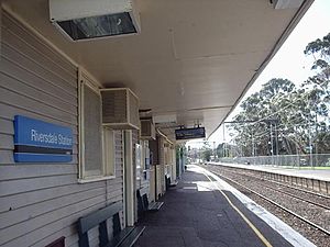
Riversdale railway station
Railway station in Melbourne, Australia
Distance: Approx. 1169 meters
Latitude and longitude: -37.8315,145.0697
Riversdale railway station is a commuter railway station on the Alamein line, which is part of the Melbourne railway network. It serves the eastern suburb of Camberwell, in Melbourne, Victoria, Australia. Riversdale station is a ground level unstaffed station, featuring two side platforms.

Willison railway station
Railway station in Melbourne, Australia
Distance: Approx. 706 meters
Latitude and longitude: -37.8357,145.0703
Willison railway station is a commuter railway station on the Alamein line, part of the Melbourne railway network. It serves the eastern Melbourne suburb of Camberwell in Victoria, Australia. Willison is a ground level unstaffed station, featuring two side platforms.

Hartwell railway station
Railway station in Victoria, Australia
Distance: Approx. 593 meters
Latitude and longitude: -37.8441,145.0756
Hartwell railway station is a commuter railway station on the Alamein line, which is part of the Melbourne railway network. It serves the eastern suburb of Camberwell, in Melbourne, Victoria, Australia. Hartwell station is a ground level unstaffed station, featuring an island platform with two faces.

Burwood railway station, Melbourne
Railway station in Melbourne, Australia
Distance: Approx. 1447 meters
Latitude and longitude: -37.8516,145.0805
Burwood railway station is a commuter railway station on the Alamein line, which is part of the Melbourne railway network. It serves the eastern suburb of Glen Iris, in Melbourne, Victoria, Australia. Burwood station is a ground level unstaffed station, featuring two side platforms.

Our Lady of Victories Basilica, Camberwell
Church in Australia
Distance: Approx. 1449 meters
Latitude and longitude: -37.8338,145.0566
Our Lady of Victories Basilica is a Roman Catholic church located in the Melbourne suburb of Camberwell. Romanesque Revival in style, it was designed by architect Augustus Andrew Fritsch and was completed in 1918. It is one of five churches in Australia with minor basilica status.

Camberwell High School
Public school in Canterbury, Victoria, Australia
Distance: Approx. 1320 meters
Latitude and longitude: -37.83055556,145.07333333
Camberwell High School is a government-funded, government run, co-educational high school for years 7 to 12, located on Prospect Hill Road in Canterbury, a suburb of Melbourne, Victoria, Australia. Camberwell High School is located on a 3.2-hectare site in Canterbury, which lies about twelve kilometres from Melbourne's Central Business District. Its school zone includes the affluent suburbs of Ashburton, Camberwell, Canterbury, Surrey Hills, Hartwell, Burwood, Hawthorn and Hawthorn East.

Camberwell Town Hall
Heritage former town hall
Distance: Approx. 1174 meters
Latitude and longitude: -37.834582,145.059904
The Camberwell Town Hall is situated at 360 Camberwell Road. It was constructed for the Boroondara Shire Council in the late 1880s, in the Free Classical style. It became the Camberwell Town Hall when the town was proclaimed in 1906, which became the City of Camberwell in 1914.

Brinsley Road Community School
School
Distance: Approx. 1460 meters
Latitude and longitude: -37.82888889,145.06916667
Brinsley Road Community School was a state-run high school (years 7–12) in the suburb of Camberwell, in Melbourne, Victoria, Australia. The school was established in February 1973 under the umbrella of Camberwell High School with the support of Camberwell High School's progressive principal Margaret Essex. The school was formally referred to by the Education Department as the "Camberwell High Annex".
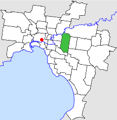
Electoral district of Glen Iris
Former state electoral district of Victoria, Australia
Distance: Approx. 922 meters
Latitude and longitude: -37.85,145.06666667
The Electoral district of Glen Iris was an electoral district of the Victorian Legislative Assembly. It was created in the redistribution of 1945 when several districts including Boroondara were abolished. Glen Iris was abolished in the 1955 redistribution when several districts including Burwood and Caulfield East were created.

City of Camberwell
Local government area in Victoria, Australia
Distance: Approx. 792 meters
Latitude and longitude: -37.835,145.071
The City of Camberwell was a local government area about 10 kilometres (6 mi) east of Melbourne, the state capital of Victoria, Australia. The city covered an area of 36.01 square kilometres (13.90 sq mi), and existed from 1914 until 1994.
Electoral district of Camberwell
Former state electoral district of Victoria, Australia
Distance: Approx. 994 meters
Latitude and longitude: -37.83333333,145.06666667
Camberwell was an electoral district of the Legislative Assembly in the Australian state of Victoria from 1945 to 1976. It centred on the eastern Melbourne suburb of Camberwell.
Weather in this IP's area
broken clouds
17 Celsius
17 Celsius
15 Celsius
18 Celsius
1017 hPa
85 %
1017 hPa
1013 hPa
10000 meters
1.34 m/s
3.58 m/s
138 degree
66 %
