Country:
 Hong Kong (China)
Region:
City:
Latitude and Longitude:
Time Zone:
Postal Code:
IP information under different IP Channel
ip-api
Country
Region
City
ASN
Time Zone
ISP
Blacklist
Proxy
Latitude
Longitude
Postal
Route
IPinfo
Country
Region
City
ASN
Time Zone
ISP
Blacklist
Proxy
Latitude
Longitude
Postal
Route
MaxMind
Country
Region
City
ASN
Time Zone
ISP
Blacklist
Proxy
Latitude
Longitude
Postal
Route
Luminati
Country
 CA
CAASN
Time Zone
America/Toronto
ISP
ChangLian Network Technology Co., Limited
Latitude
Longitude
Postal
db-ip
Country
Region
City
ASN
Time Zone
ISP
Blacklist
Proxy
Latitude
Longitude
Postal
Route
ipdata
Country
Region
City
ASN
Time Zone
ISP
Blacklist
Proxy
Latitude
Longitude
Postal
Route
Popular places and events near this IP address

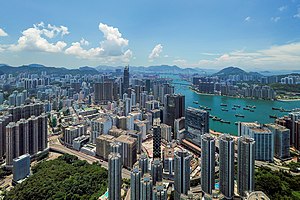
New Territories
Area of Hong Kong
Distance: Approx. 2237 meters
Latitude and longitude: 22.41,114.125
The New Territories (abbr. N.T. , Chinese: 新界) is one of the three areas of Hong Kong, alongside Hong Kong Island and the Kowloon Peninsula. It makes up 86.2% of Hong Kong's territory, and contains around half of the population of Hong Kong.

Yuen Yuen Institute
Distance: Approx. 2031 meters
Latitude and longitude: 22.38333333,114.12277778
The Yuen Yuen Institute (Chinese: 圓玄學院; Jyutping: jyun4 jyun4 hok6 jyun2) is a Taoist temple in Lo Wai, Tsuen Wan District, Hong Kong.
Chai Wan Kok
Area in Tsuen Wan, Hong Kong
Distance: Approx. 1725 meters
Latitude and longitude: 22.38333333,114.1
Chai Wan Kok (Chinese: 柴灣角) is an area in Tsuen Wan, Hong Kong. It is located at the west end of Tsuen Wan Town. While its southeast is industrial area, its hilly northeast and coastal southwest are residential.

Tai Mo Shan Road
Distance: Approx. 1896 meters
Latitude and longitude: 22.4102,114.1198
Tai Mo Shan Road (Chinese: 大帽山道; Jyutping: daai6 mou6 saan1 dou6; pinyin: Dàmàoshāndào) is a road in New Territories, Hong Kong. It originates from Route Twisk and leads to (but does not terminate at) the weather station at the top of Tai Mo Shan. Paved the whole way, the upper-most roughly 3 kilometres (1.9 mi) route is blocked by a staffed barrier gate, and is hence inaccessible to motor vehicles, except those on government or military service.
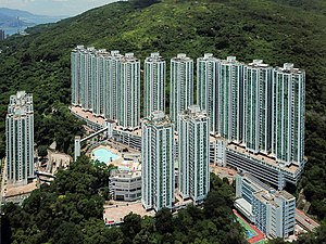
Allway Gardens
Housing estate in Tsuen Wan, Hong Kong
Distance: Approx. 1963 meters
Latitude and longitude: 22.3788,114.1078
Allway Gardens (Chinese: 荃威花園) is the earliest and one of the largest-scale private housing estates located in Tsuen Wan, New Territories, Hong Kong. It was developed by Hopewell Holdings. It is located on Tsuen King Circuit, a hilltop at the west of Tsuen Wan.
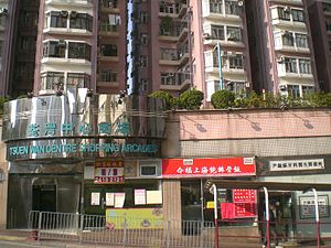
Tsuen Wan Centre
Distance: Approx. 1963 meters
Latitude and longitude: 22.3788,114.1078
Tsuen Wan Centre (Chinese: 荃灣中心) is one of the largest private housing estates in Tsuen Wan, New Territories, Hong Kong, located at Tsuen King Circuit. It consists of 19 high-rise buildings, with their names of a number of Chinese cities, and a shopping arcade. It was divided into 3 phases which were completed between 1980 and 1982, and was developed by Sun Hung Kai Properties.
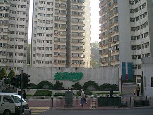
Tsuen King Garden
Housing estate in Tsuen Wan, Hong Kong
Distance: Approx. 2004 meters
Latitude and longitude: 22.3784,114.1095
Tsuen King Garden (Chinese: 荃景花園) is one of the largest private housing estates in Tsuen Wan, New Territories, Hong Kong, located at Tsuen King Circuit. It comprises 12 high-rise buildings in two phases which were completed between 1987 and 1988, and was developed by Sun Hung Kai Properties.

The Cairnhill
Private housing estate in Tsuen Wan, New Territories, Hong Kong
Distance: Approx. 1257 meters
Latitude and longitude: 22.38511,114.10935
The Cairnhill (Chinese: 朗逸峯) is a private housing estate in Tsuen Wan, New Territories, Hong Kong. Being one of the estates built on many d level of the hill of Route Twisk (Another one is The Cliveden), it consists of 16 low-density blocks divided into 2 phases and completed in 2004 and 2005 respectively, offering a total of 770 units. It was jointly developed by Cheung Kong Holdings, Sino Land and K. Wah International.

The Cliveden
Distance: Approx. 1356 meters
Latitude and longitude: 22.38422,114.10917
The Cliveden (Chinese: 寶雲匯) is a private housing estate in mid-level of Route Twisk, Tsuen Wan, New Territories, Hong Kong, next to The Cairnhill. It is a low-density European-style luxury residential development project in the mid-levels of Tsuen Wan District, with a total of 9 residential buildings (there is no 4th block). It was jointly developed by Kerry Properties and Sino Land in 2002.
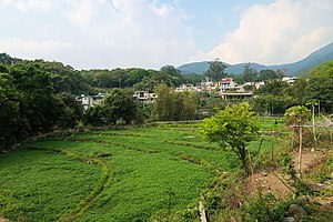
Chuen Lung
Village of Hong Kong
Distance: Approx. 460 meters
Latitude and longitude: 22.39297,114.1115
Chuen Lung (Chinese: 川龍) is a village in Tsuen Wan District, Hong Kong.
Ha Fa Shan
Distance: Approx. 2048 meters
Latitude and longitude: 22.383107,114.095245
Ha Fa Shan (Chinese: 下花山) is a village in Tsuen Wan District, Hong Kong.
Lin Fa Shan, Tsuen Wan
Mountain in Tsuen Wan, Hong Kong
Distance: Approx. 2029 meters
Latitude and longitude: 22.398086,114.089372
Lin Fa Shan (Chinese: 蓮花山; lit. 'lotus flower hill') is mountain in Hong Kong. With a height of 1,896 ft (578 m) in Tsuen Wan District, it is situated within Tai Lam Country Park.
Weather in this IP's area
overcast clouds
29 Celsius
34 Celsius
29 Celsius
30 Celsius
1005 hPa
70 %
1005 hPa
970 hPa
10000 meters
2.68 m/s
5.81 m/s
169 degree
100 %
06:11:28
18:23:23