Country:
 India
IndiaRegion:
City:
Latitude and Longitude:
Time Zone:
Postal Code:
IP information under different IP Channel
ip-api
Country
Region
City
ASN
Time Zone
ISP
Blacklist
Proxy
Latitude
Longitude
Postal
Route
IPinfo
Country
Region
City
ASN
Time Zone
ISP
Blacklist
Proxy
Latitude
Longitude
Postal
Route
MaxMind
Country
Region
City
ASN
Time Zone
ISP
Blacklist
Proxy
Latitude
Longitude
Postal
Route
Luminati
Country
INASN
Time Zone
Asia/Kolkata
ISP
Extreme IX
Latitude
Longitude
Postal
db-ip
Country
Region
City
ASN
Time Zone
ISP
Blacklist
Proxy
Latitude
Longitude
Postal
Route
ipdata
Country
Region
City
ASN
Time Zone
ISP
Blacklist
Proxy
Latitude
Longitude
Postal
Route
Popular places and events near this IP address

Lajpat Nagar
Neighborhood of Delhi in South East Delhi, India
Distance: Approx. 128 meters
Latitude and longitude: 28.56805556,77.24166667
Lajpat Nagar is a residential and commercial neighborhood in the South East Delhi district of Delhi. It was named in honor of Lala Lajpat Rai and is today most known for the Lajpat Nagar Central Market. This area is not to be confused with the Lajpat Nagar in Ghaziabad in the NCR region.
Dayanand Colony
Neighborhood of Delhi in South Delhi, India
Distance: Approx. 986 meters
Latitude and longitude: 28.5625,77.2484
Dayanand Colony is part of the Lajpat Nagar area of Delhi. It falls under Lajpat Nagar-4 in South Delhi. By 1957, it was named after Dayanand Saraswati.

Municipal Corporation of Delhi
Municipal Corporation in National Capital Territory of Delhi, India
Distance: Approx. 474 meters
Latitude and longitude: 28.566,77.245
Municipal Corporation of Delhi (MCD; ISO: Dillī Nagara Nigama) is the municipal corporation that governs most of Delhi, India. The MCD is among the largest municipal bodies in the world providing civic services to a population of about 20 million citizens in the capital city Delhi. It is headed by the Mayor of Delhi, who presides over elected councillors from 250 wards.
The Frank Anthony Public School, New Delhi
Private school in New Delhi, India, Delhi, India
Distance: Approx. 1090 meters
Latitude and longitude: 28.561,77.2357
The Frank Anthony Public School (often abbreviated as 'FAPS') is a public day-school in New Delhi, India, for students ranging from 3–18 years.
Sriniwaspuri
Neighborhood of Delhi in India
Distance: Approx. 850 meters
Latitude and longitude: 28.56666667,77.25
Sriniwaspuri (Hindi: श्रीनिवासपुरी) is a small Colony located in the southern part of Delhi, India. It is the only place in Delhi where Emperor Ashoka’s Rock Edict was discovered. The in-situ Bahapur rock edict (28.55856°N 77.25662°E) was discovered in Delhi is a minor edict that is in an engraved form on a small patch of rock exposure in Sriniwaspuri.

Lajpat Nagar metro station
Metro station in Delhi, India
Distance: Approx. 544 meters
Latitude and longitude: 28.57056581,77.23646031
Lajpat Nagar is an interchange station between Violet Line and Pink Line of the Delhi Metro in Delhi. It is located between Jangpura and Moolchand on the Violet Line in Lajpat Nagar. The station was opened with the first section of the Violet Line on 3 October 2010, in time for the Commonwealth Games opening ceremony on the same day.

Moolchand metro station
Metro station in Delhi, India
Distance: Approx. 939 meters
Latitude and longitude: 28.56398519,77.23424481
Moolchand is a Delhi Metro station in Delhi. It is located between Lajpat Nagar and Kailash Colony stations on the Violet Line. The station was opened with the first section of the Line on 3 October 2010 in time for the Commonwealth Games opening ceremony on the same day.
Defence Colony
Neighborhood of Delhi in South East Delhi, India
Distance: Approx. 1157 meters
Latitude and longitude: 28.57,77.23
Defence Colony is a neighbourhood in Delhi. It was built in the 1960s for veterans of the Indian Armed Forces. It serves as the administrative headquarters of the South East Delhi district of Delhi.
Max Med Centre Services Lajpat Nagar
Hospital in New Delhi, India
Distance: Approx. 527 meters
Latitude and longitude: 28.564771,77.239907
Max Institute of Cancer Care Lajpat Nagar is a healthcare facility situated in New Delhi, India.

Vidyasagar Institute of Mental Health and Neuro and Allied Sciences
Hospital in Delhi, India
Distance: Approx. 883 meters
Latitude and longitude: 28.56927778,77.25083333
Sagar Institute of Mental Health and Neuro and Allied Sciences (VIMHANS) is a mental healthcare institution in South Delhi. It was founded in 1987 as a tribute to the Indian psychiatrist Vidya Sagar.
Bluebells School International
International school in New Delhi, India
Distance: Approx. 1195 meters
Latitude and longitude: 28.559,77.238
Bluebells School International is an international school in Kailash Colony, New Delhi, India. As of 2015, the school has 1,875 students in levels Nursery through XII, with 150 teachers. It has Pre-Primary, Primary School, Middle School, and Secondary & Senior Secondary programmes.
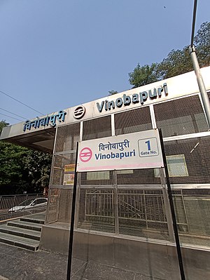
Vinobapuri metro station
Metro station in Delhi, India
Distance: Approx. 925 meters
Latitude and longitude: 28.56594389,77.25050194
The Vinobapuri metro station is located on the Pink Line of the Delhi Metro. The station was opened for public on 31 December 2018. As part of Phase III of Delhi Metro, Vinobapuri is the metro station of the Pink Line.
Weather in this IP's area
mist
24 Celsius
25 Celsius
24 Celsius
24 Celsius
1006 hPa
94 %
1006 hPa
982 hPa
2500 meters
3.6 m/s
40 degree
75 %
06:08:02
18:21:41