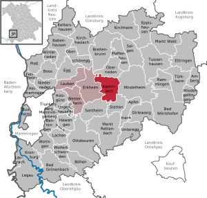
103.76.96.112 - IP Lookup: Free IP Address Lookup, Postal Code Lookup, IP Location Lookup, IP ASN, Public IP
Country:
Region:
City:
Location:
Time Zone:
Postal Code:
IP information under different IP Channel
ip-api
Country
Region
City
ASN
Time Zone
ISP
Blacklist
Proxy
Latitude
Longitude
Postal
Route
Luminati
Country
ASN
Time Zone
Europe/Berlin
ISP
LEW TelNet GmbH
Latitude
Longitude
Postal
IPinfo
Country
Region
City
ASN
Time Zone
ISP
Blacklist
Proxy
Latitude
Longitude
Postal
Route
IP2Location
103.76.96.112Country
Region
bayern
City
mindelheim
Time Zone
Europe/Berlin
ISP
Language
User-Agent
Latitude
Longitude
Postal
db-ip
Country
Region
City
ASN
Time Zone
ISP
Blacklist
Proxy
Latitude
Longitude
Postal
Route
ipdata
Country
Region
City
ASN
Time Zone
ISP
Blacklist
Proxy
Latitude
Longitude
Postal
Route
Popular places and events near this IP address
Unterallgäu
District in Bavaria, Germany
Distance: Approx. 5131 meters
Latitude and longitude: 48,10.5
Unterallgäu is a Landkreis (district) in Swabia, Bavaria, Germany. Neighboring districts are (from the north clockwise) Neu-Ulm, Günzburg, Augsburg, Ostallgäu, Oberallgäu, and the districts Ravensburg und Biberach in Baden-Württemberg. The district-free city Memmingen in the west of the district is nearly surrounded by the district.

Grob Aircraft
German aircraft manufacturer, founded 1971
Distance: Approx. 7725 meters
Latitude and longitude: 48.11194444,10.52361111
Grob Aircraft, formerly Grob Aerospace, is a German aircraft manufacturer, specialising in gliders and general aviation. Since its foundation in 1971, Grob Aircraft produced a range of aircraft. Initially focusing on gliders, it soon grew into other markets.

Mindelheim
Town in Bavaria, Germany
Distance: Approx. 2353 meters
Latitude and longitude: 48.03333333,10.46666667
Mindelheim (German: [ˈmɪndl̩ˌhaɪ̯m] ; Swabian: Mindelhoi) is a town in Swabia, Bavaria, Germany. The town is the capital of the Unterallgäu district. At various points in history it was the chief settlement of an eponymous state.

Dirlewang
Municipality in Bavaria, Germany
Distance: Approx. 5131 meters
Latitude and longitude: 48,10.5
Dirlewang is a market town and municipality in the district of Unterallgäu in Bavaria, Germany. The town is seat of a municipal association with Apfeltrach, Stetten, Bavaria and Unteregg. The town of Dirlewang is recorded as one of place where Johannes Gossner, German evangelist and philanthropist, staying from 1804 until 1811.

Apfeltrach
Municipality in Bavaria, Germany
Distance: Approx. 3295 meters
Latitude and longitude: 48.01666667,10.5
Apfeltrach is a municipality in the district of Unterallgäu in Bavaria, Germany. The town has a municipal association with Dirlewang.

Kammlach
Municipality in Bavaria, Germany
Distance: Approx. 5640 meters
Latitude and longitude: 48.05,10.41666667
Kammlach is a municipality in the district of Unterallgäu in Bavaria, Germany. The town has a municipal association with Erkheim.
Rammingen, Bavaria
Municipality in Bavaria, Germany
Distance: Approx. 7168 meters
Latitude and longitude: 48.06666667,10.58333333
Rammingen is a municipality in the district of Unterallgäu in Bavaria, Germany. The town has a municipal association with Türkheim.

Stetten, Bavaria
Municipality in Bavaria, Germany
Distance: Approx. 4596 meters
Latitude and longitude: 48.03333333,10.43333333
Stetten (German pronunciation: [ˈʃtɛtn̩] ) is a municipality in the district of Unterallgäu in Bavaria, Germany. The town has a municipal association with Dirlewang. It is located in Upper Swabia.
Schwäbisches Turmuhrenmuseum
Horological museum in Hungerbachgasse, Mindelheim
Distance: Approx. 419 meters
Latitude and longitude: 48.04698,10.48685
The Schwäbisches Turmuhrenmuseum in Mindelheim, Germany is a small horological museum dedicated to the history of towerclocks. It is located in a former historic church, the Silvesterkirche, as well as the associated clocktower, the Kappelturm. Large working towerclocks are located on every floor of the tower, allowing the visitor to fully experience towerclocks in their natural environment.
Westernach (Mindel)
River in Germany
Distance: Approx. 4539 meters
Latitude and longitude: 48.0847,10.4739
Westernach is a river of Bavaria, Germany. It is a tributary of the Mindel near Mindelheim.

Mindelheim station
Railway station in Mindelheim, Germany
Distance: Approx. 717 meters
Latitude and longitude: 48.044892,10.501733
Mindelheim station is the station of the district town of Mindelheim in the German state of Bavaria and lies about one km south of the original town.
Skyline Park
Amusement Park in Bavaria, Germany
Distance: Approx. 7378 meters
Latitude and longitude: 48.043055,10.591245
Skyline Park (also known as Allgäu Skyline Park) is a 35-hectare (86-acre) amusement park in Bad Wörishofen, Bavaria, Germany. The facility includes several thrill rides, family attractions, and playground amenities. The park is run by the Löwenthal family of showmen.
Weather in this IP's area
mist
-5 Celsius
-8 Celsius
-6 Celsius
-3 Celsius
1038 hPa
87 %
1038 hPa
963 hPa
3000 meters
2.06 m/s
30 degree
42 %

