Country:
 Singapore
Region:
City:
Latitude and Longitude:
Time Zone:
Postal Code:
IP information under different IP Channel
ip-api
Country
Region
City
ASN
Time Zone
ISP
Blacklist
Proxy
Latitude
Longitude
Postal
Route
IPinfo
Country
Region
City
ASN
Time Zone
ISP
Blacklist
Proxy
Latitude
Longitude
Postal
Route
MaxMind
Country
Region
City
ASN
Time Zone
ISP
Blacklist
Proxy
Latitude
Longitude
Postal
Route
Luminati
Country
SGASN
Time Zone
Asia/Singapore
ISP
Northtelecom PTE LTD
Latitude
Longitude
Postal
db-ip
Country
Region
City
ASN
Time Zone
ISP
Blacklist
Proxy
Latitude
Longitude
Postal
Route
ipdata
Country
Region
City
ASN
Time Zone
ISP
Blacklist
Proxy
Latitude
Longitude
Postal
Route
Popular places and events near this IP address

Singapore Expo
Distance: Approx. 680 meters
Latitude and longitude: 1.33403333,103.95893056
Singapore EXPO is the largest convention and exhibition venue in Singapore with over 100,000 square metres of column-free, indoor space spread over 10 halls. The center was designed by Cox Richardson Rayner, built by PSA International, and funded by the Ministry of Trade and Industry. The S$220 million building (excluding the cost of the 40,000 m² expansion) is located in Tampines, Singapore.
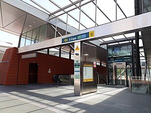
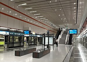
Expo MRT station
Mass Rapid Transit station in Singapore
Distance: Approx. 346 meters
Latitude and longitude: 1.33527778,103.96194444
Expo MRT station is a Mass Rapid Transit (MRT) interchange station on the East West line (EWL) and Downtown line (DTL) in the Tampines planning area, Singapore. The station lies between Changi City Point and the Singapore Expo, located along Changi South Avenue 1 at the junction of Expo Drive. The station is part of the two-station branch line which extends from Tanah Merah to Changi Airport station.
University of New South Wales Asia
Distance: Approx. 678 meters
Latitude and longitude: 1.3408,103.9647
The University of New South Wales Asia (Abbreviation: UNSW Asia; Chinese: 亚洲新南威尔斯大学) was the first international university campus for the University of New South Wales in Singapore which opened on 12 March 2007. UNSW Asia was the first foreign university and fifth university in Singapore. On 23 May 2007, UNSW Asia Singapore campus announced its planned closure on 28 June 2007, at the end of the first semester due to financial issues and lower than expected student numbers.
Singapore Flying College
Flight school in Singapore
Distance: Approx. 1201 meters
Latitude and longitude: 1.3453,103.9629
The Singapore Flying College (Abbreviation: SFC) is a CAAS approved flight school based in Singapore. Established in 1988 under the Singapore Airlines Group, it is the training school for cadet pilots with Singapore Airlines, Scoot and Singapore Airlines Cargo. The SFC headquarters is located at SIA Training Centre, Singapore, in close proximity to Changi Airport and is where the ATPL ground training phase is conducted.
ITE College East
Singapore vocational school
Distance: Approx. 1146 meters
Latitude and longitude: 1.334475,103.95470278
ITE College East (ITECE) is a post-secondary education institution and statutory board under the purview of the Ministry of Education in Singapore. It is one of the Institute of Technical Education's three colleges under the "One ITE System, Three Colleges" Governance and Education Model.

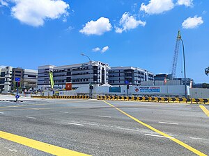
Changi Business Park
Distance: Approx. 34 meters
Latitude and longitude: 1.33497222,103.96516667
The Changi Business Park (CBP) is a business park located in Changi South, in the eastern part of Singapore.

Singapore University of Technology and Design
Public university in Tampines, Singapore
Distance: Approx. 747 meters
Latitude and longitude: 1.341313,103.963757
The Singapore University of Technology and Design (SUTD) is a public autonomous university in Singapore.
Upper Changi MRT station
Mass Rapid Transit station in Singapore
Distance: Approx. 894 meters
Latitude and longitude: 1.3419,103.9614
Upper Changi MRT station is an underground Mass Rapid Transit station on the Downtown Line in Tampines planning area, Singapore, located under Upper Changi Road East. The station serves residential estates in the vicinity and the campus of the Singapore University of Technology and Design, which is linked via an underground linkway. The station, along with Fort Canning, is one of the longest stations along the line, at 205 meters.

Changi City Point
Shopping mall in Singapore
Distance: Approx. 260 meters
Latitude and longitude: 1.3343,103.9627
Changi City Point (Chinese: 樟城坊) is a shopping mall located in the vicinity of Changi Business Park, Singapore. It was constructed from June 2010, and completed in November 2011. In 2014, Changi City Point was sold by joint owners, Ascendas Frasers and Ascendas Development, to Frasers Centrepoint Trust (FCT) for $305 million.
Xilin MRT station
Future Mass Rapid Transit station in Singapore
Distance: Approx. 648 meters
Latitude and longitude: 1.3289,103.9649
Xilin MRT station is a future underground Mass Rapid Transit station on the Downtown line in Tampines planning area, Singapore. Taking its name from Xilin Avenue which passes overhead, Xilin station serves industries around Changi South, as well as the nearby Tanah Merah Country Club. The station is located at the junction of Xilin Avenue, Changi South Avenue 3 and Laguna Golf Green.

East Coast Integrated Depot
MRT and bus depot in Singapore
Distance: Approx. 1182 meters
Latitude and longitude: 1.32736,103.95734
The East Coast Integrated Depot (ECID) is a large integrated bus and train depot located in Changi that will serve three Mass Rapid Transit (MRT) lines in Singapore, the East–West Line (EWL), the Downtown Line (DTL) and the Thomson–East Coast Line (TEL). It is currently under construction, with expected completion in 2026. The depot will be located beside the current site of Changi Depot, which will be demolished.
Le Freeport
High-security storage facility in Singapore
Distance: Approx. 1232 meters
Latitude and longitude: 1.345,103.9691
Le Freeport, formerly known as Singapore Freeport, is a high-security storage and display facility in Singapore. A majority stake is held by Natural Le Coultre S.A. of art dealer and shipper Yves Bouvier. Opened near Singapore Changi Airport in May 2010, the facility is modelled after similar institutions in Geneva and Luxembourg.
Weather in this IP's area
light intensity shower rain
29 Celsius
33 Celsius
29 Celsius
33 Celsius
1010 hPa
70 %
1010 hPa
1009 hPa
10000 meters
7.2 m/s
130 degree
75 %
06:58:08
19:05:52