103.75.159.127 - IP Lookup: Free IP Address Lookup, Postal Code Lookup, IP Location Lookup, IP ASN, Public IP
Country:
 India
IndiaRegion:
City:
Location:
Time Zone:
Postal Code:
ISP:
ASN:
language:
User-Agent:
Proxy IP:
Blacklist:
IP information under different IP Channel
ip-api
Country
Region
City
ASN
Time Zone
ISP
Blacklist
Proxy
Latitude
Longitude
Postal
Route
db-ip
Country
Region
City
ASN
Time Zone
ISP
Blacklist
Proxy
Latitude
Longitude
Postal
Route
IPinfo
Country
Region
City
ASN
Time Zone
ISP
Blacklist
Proxy
Latitude
Longitude
Postal
Route
IP2Location
103.75.159.127Country
inRegion
tamil nadu
City
tiruchirappalli
Time Zone
Asia/Kolkata
ISP
Language
User-Agent
Latitude
Longitude
Postal
ipdata
Country
Region
City
ASN
Time Zone
ISP
Blacklist
Proxy
Latitude
Longitude
Postal
Route
Popular places and events near this IP address
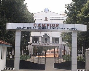
Campion Anglo-Indian Higher Secondary School
Secondary school in Tiruchirapalli, India
Distance: Approx. 1265 meters
Latitude and longitude: 10.805475,78.68449
Campion Anglo-Indian Higher Secondary School was started in the year 1934 at Tiruchirapalli, Tamil Nadu, India. The school is named after its patron saint, St. Edmund Campion.

Bishop Heber College
Educational Institution ,Thirichirapalli , Tamilnadu, India
Distance: Approx. 913 meters
Latitude and longitude: 10.8188,78.6754
Bishop Heber College is a religious minority educational institution in Tiruchirappalli, Tamil Nadu, India. It was founded in 1966, although the school has historical roots extending through various earlier local religious schools to about the mid-nineteenth century. Bishop Heber College offers several undergraduate and graduate degrees including the doctorate level.
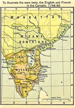
Siege of Trichinopoly (1743)
1743 siege and capture of Trichinopoly by Nizam of Hyderabad
Distance: Approx. 1333 meters
Latitude and longitude: 10.805,78.68555556
The siege of Trichinopoly (14 March 1743 – 29 August 1743) was part of an extended series of conflicts between the Nizam of Hyderabad and the Maratha Empire for control of the Carnatic region. On 29 August 1743, after a six-month siege, Murari Rao surrendered, giving Nizam ul Mulk (Nizam) the suzerainty of Trichinopoly. By the end of 1743, the Nizam had regained full control of Deccan.

Abhishekapuram
Distance: Approx. 797 meters
Latitude and longitude: 10.813178,78.677216
Abhishekapuram (Tamil: அபிஷேகபுரம்) is a suburb of the city of Tiruchirappalli in Tamil Nadu, India. It constitutes one of the four zones of the Tiruchirappalli Municipal Corporation.

Tiruchirappalli Fort
Historic site in Trichirapalli, India
Distance: Approx. 1130 meters
Latitude and longitude: 10.825334,78.689103
Tiruchirappalli Fort is a dilapidated fort in India which once protected the Old City of Trichy encompassing Big Bazaar Street, Singarathope, Bishop Heber School, Teppakulam and Tiruchirapalli Rock Fort. All that remains now is a railway station with that name and Main Guard Gate along West Boulevard Road in the city of Tiruchirappalli in Tamil Nadu. The fort can be traced along West Boulevard Road in West, East Boulevard Road in East, Butter-worth Road in North and Gandhi Market to the South.

Beema Nagar
Distance: Approx. 1176 meters
Latitude and longitude: 10.808736,78.690452
Beema Nagar (Tamil: பீம நகர்) is an area of the city of Tiruchirapalli in the Indian state of Tamil Nadu. The district court and district registrar office are located within the neighborhood.
Tiruchirappalli Fort Railway Station
Historic site in Trichirapalli, India
Distance: Approx. 1069 meters
Latitude and longitude: 10.8248,78.6889
Tiruchirappalli Fort Railway Station (station code: TP) is an NSG–5 category Indian railway station in Tiruchirappalli railway division of Southern Railway zone. It is a Railway station which once served that citizens of the dilapidated fort of Old City of Trichy encompassing Big Bazaar Street, Singarathope, Bishop Heber School, Teppakulam and Tiruchirapalli Rock Fort. All that which remains now is a railway station with that name and Main Guard Gate along West Boulevard Road in the city of Tiruchirappalli in Tamil Nadu, India.
Pathalapattai
Village in Tamil Nadu, India
Distance: Approx. 1333 meters
Latitude and longitude: 10.805,78.68555556
Pathalapattai is a village in Tiruchirappalli taluk of Tiruchirappalli district in Tamil Nadu, India.
Tiruchirappalli Town railway station
Historic site in Trichirapalli, India
Distance: Approx. 1069 meters
Latitude and longitude: 10.8248,78.6889
Tiruchirapalli Town railway station (station code:TPTN) is an NSG–6 category Indian railway station in Tiruchirappalli railway division of Southern Railway zone. It is the railway station located near to Rockfort.
World War I Memorial (Tiruchirappalli)
World War I Memorial in Tiruchirappalli
Distance: Approx. 1451 meters
Latitude and longitude: 10.8155,78.6967
World War I Memorial, located opposite to Gandhi Market, Tiruchirappalli in the state of Tamil Nadu, India, is a war memorial dedicated to the soldiers of Trichinopoly.
Holy Cross College, Tiruchirappalli
Women's college in Tamil Nadu, India
Distance: Approx. 1274 meters
Latitude and longitude: 10.82457,78.692055
Holy Cross College is an autonomous women's college located in Tiruchirappalli, Tamil Nadu, India. It has been recognized as the 'College with Potential for Excellence (CPE)' by the University Grants Commission. The college is ranked 39th among colleges in India by the National Institutional Ranking Framework (NIRF) in 2024.
Maruti Hospital, Tiruchirappalli
Hospital in Tamil Nadu, India
Distance: Approx. 842 meters
Latitude and longitude: 10.8099833,78.6801677
Maruti Hospital is a multi-speciality hospital located in Tiruchirappalli, Tamil Nadu, India.
Weather in this IP's area
few clouds
34 Celsius
36 Celsius
34 Celsius
34 Celsius
1010 hPa
43 %
1010 hPa
1001 hPa
6000 meters
3.09 m/s
50 degree
20 %