Country:
Region:
City:
Latitude and Longitude:
Time Zone:
Postal Code:
IP information under different IP Channel
ip-api
Country
Region
City
ASN
Time Zone
ISP
Blacklist
Proxy
Latitude
Longitude
Postal
Route
Luminati
Country
Region
sa
City
adelaide
ASN
Time Zone
Australia/Adelaide
ISP
Falcore Investments Pty Ltd
Latitude
Longitude
Postal
IPinfo
Country
Region
City
ASN
Time Zone
ISP
Blacklist
Proxy
Latitude
Longitude
Postal
Route
db-ip
Country
Region
City
ASN
Time Zone
ISP
Blacklist
Proxy
Latitude
Longitude
Postal
Route
ipdata
Country
Region
City
ASN
Time Zone
ISP
Blacklist
Proxy
Latitude
Longitude
Postal
Route
Popular places and events near this IP address

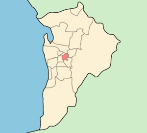
City of Norwood Payneham & St Peters
Local government area in South Australia
Distance: Approx. 838 meters
Latitude and longitude: -34.91666667,138.63333333
The City of Norwood Payneham & St Peters is a metropolitan local government area of South Australia. It covers the inner eastern suburbs of Adelaide. It is divided into five wards: Torrens, Payneham, West Norwood/Kent Town, Kensington (each electing two councillors), and Maylands/Trinity (three councillors).

Prince Alfred College
Independent, single-sex, day & boarding school in Kent Town, South Australia, Australia
Distance: Approx. 902 meters
Latitude and longitude: -34.9225,138.61916667
Prince Alfred College (also referred to as PAC, Princes, or in sporting circles, the Reds) is a private, independent, day and boarding school for boys, located on Dequetteville Terrace, Kent Town – near the centre of Adelaide, South Australia. Prince Alfred College was established in 1869 by the Methodist Church of Australasia, which amalgamated with other Protestant churches in 1977 to form the Uniting Church in Australia. The school has enrolment of some 1,160 students from Reception to Year 12 (ages 2 to 18), including some 151 boarders from years seven to twelve.

Norwood, South Australia
Suburb of Adelaide, South Australia
Distance: Approx. 367 meters
Latitude and longitude: -34.923,138.633
Norwood is a suburb of Adelaide, about 4 km (2.5 mi) east of the Adelaide city centre. The suburb is in the City of Norwood Payneham & St Peters, whose predecessor was the oldest South Australian local government municipality. The Parade runs east to west through the centre of the suburb.

City of Onkaparinga
Local government area in South Australia
Distance: Approx. 838 meters
Latitude and longitude: -34.91666667,138.63333333
The City of Onkaparinga () is a local government area (LGA) located on the southern fringe of Adelaide, South Australia. It is named after the Onkaparinga River, whose name comes from Ngangkiparinga, a Kaurna word meaning women's river. It is the largest LGA in South Australia, with a population of over 170,000 people in both urban and rural communities and is also geographically expansive, encompassing an area of 518.3 km2.
Rose Park, South Australia
Suburb of Adelaide, South Australia
Distance: Approx. 831 meters
Latitude and longitude: -34.93072,138.62798
Rose Park is a suburb with a population of 1,374 in the South Australian capital city of Adelaide. It is located 1 kilometre (0.62 mi) east of Adelaide's central business district. Rose Park is a leafy, tree-lined and wealthy inner suburb containing a number of historical and contemporary attractions.
Kent Town, South Australia
Suburb of Adelaide, South Australia
Distance: Approx. 958 meters
Latitude and longitude: -34.920278,138.619167
Kent Town is an inner suburb of Adelaide, South Australia. It is located in the City of Norwood Payneham & St Peters local government area.

Burnside Hospital
Distance: Approx. 1009 meters
Latitude and longitude: -34.9278,138.6386
Burnside Hospital, formerly Burnside War Memorial Hospital, is the only private community hospital in the City of Burnside, Adelaide, South Australia. Burnside Council suggested building a community hospital in August 1943, as part of its Post-War Reconstruction and Development Committee; it was to cost 100,000 pounds and to remain as a memorial to honour Burnside's war dead. A local resident of Toorak Gardens, Otto George Ludwig von Rieben, offered his property, a mansion called Attunga, for use as a community hospital free of charge in 1944.

Norwood Town Hall
Town hall in the suburb of Norwood in Adelaide, South Australia
Distance: Approx. 728 meters
Latitude and longitude: -34.92083333,138.63638889
The Norwood Town Hall is the council seat of the City of Norwood Payneham & St Peters, and the building includes a number of other venues. It is located at 175 The Parade in Norwood, an inner-eastern suburb of greater Adelaide, South Australia, five minutes east of the city centre. The current town hall building was completed in 1883, with the large concert hall added at the back between 1914 and 1918.

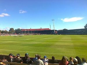
Norwood Oval
Multipurpose stadium near Adelaide, Australia
Distance: Approx. 423 meters
Latitude and longitude: -34.91972222,138.63055556
Norwood Oval (currently known as Coopers Stadium due to sponsorship from the Adelaide-based Coopers Brewery) is a suburban oval in the western end of Norwood, an inner eastern suburb of Adelaide, South Australia. The Oval has a capacity of 10,000 people, with grandstand seating for up to 3,900. Norwood Oval was built in 1901 and began hosting events from that year but was officially opened in 1906 to host football matches.
Britannia Roundabout
Roundabout, Adelaide, South Australia
Distance: Approx. 718 meters
Latitude and longitude: -34.92777778,138.62333333
The Britannia Roundabout is a roundabout intersection on the eastern side of the City Ring Route near the city centre of Adelaide, and is named for the Britannia Hotel, adjacent. Before it was upgraded in 2014 it was regarded as a traffic black spot, many minor collisions having occurred there. The five roads which join the intersection are (in clockwise order) Fullarton Road (to the north), Kensington Road to the east, Fullarton Road (to the south), Wakefield Road (to the west) and Dequetteville Terrace (to the northwest).

Attunga, Toorak Gardens
Distance: Approx. 965 meters
Latitude and longitude: -34.92777778,138.63805556
Attunga was a mansion which now forms part of Burnside Hospital, in Toorak Gardens, South Australia.

City of Kensington and Norwood
Local government area in South Australia
Distance: Approx. 728 meters
Latitude and longitude: -34.92094,138.636433
The City of Kensington and Norwood, originally the Corporate Town of Kensington and Norwood, was a local government area in South Australia from 1853 to 1997, centred on the inner eastern Adelaide suburbs of Kensington and Norwood. In November 1997 it amalgamated with the City of Payneham and the Town of St Peters to form the City of Norwood Payneham & St Peters.
Weather in this IP's area
broken clouds
16 Celsius
15 Celsius
15 Celsius
17 Celsius
1023 hPa
59 %
1023 hPa
1016 hPa
10000 meters
5.14 m/s
210 degree
75 %
05:59:58
20:01:37
