Country:
 Australia
Region:
City:
Latitude and Longitude:
Time Zone:
Postal Code:
IP information under different IP Channel
ip-api
Country
Region
City
ASN
Time Zone
ISP
Blacklist
Proxy
Latitude
Longitude
Postal
Route
IPinfo
Country
Region
City
ASN
Time Zone
ISP
Blacklist
Proxy
Latitude
Longitude
Postal
Route
MaxMind
Country
Region
City
ASN
Time Zone
ISP
Blacklist
Proxy
Latitude
Longitude
Postal
Route
Luminati
Country
AUASN
Time Zone
Australia/Sydney
ISP
INFINET VOICE & DATA PTY LTD
Latitude
Longitude
Postal
db-ip
Country
Region
City
ASN
Time Zone
ISP
Blacklist
Proxy
Latitude
Longitude
Postal
Route
ipdata
Country
Region
City
ASN
Time Zone
ISP
Blacklist
Proxy
Latitude
Longitude
Postal
Route
Popular places and events near this IP address

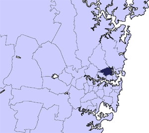
Chatswood, New South Wales
Suburb of Sydney, New South Wales, Australia
Distance: Approx. 324 meters
Latitude and longitude: -33.79666667,151.18138889
Chatswood is a suburb in the Lower North Shore of Sydney, in the state of New South Wales, Australia, 10 kilometres north of the Sydney central business district. It is the administrative centre of the local government area of the City of Willoughby.

Chatswood railway station
Railway station in Sydney
Distance: Approx. 379 meters
Latitude and longitude: -33.797324,151.180887
Chatswood railway station is a railway station located in the Sydney suburb of Chatswood. It is served by Sydney Trains services; the T1 North Shore & Western Line and the T9 Northern Line, and the Sydney Metro's North West & Bankstown Line.
City of Willoughby
Local government area in New South Wales, Australia
Distance: Approx. 736 meters
Latitude and longitude: -33.8,151.18333333
The City of Willoughby is a local government area on the Lower North Shore of Northern Sydney, in the state of New South Wales, Australia. It is located 6 kilometres (3.7 mi) north of the Sydney central business district. It was first proclaimed in October 1865 as the Municipality of North Willoughby.

Chatswood Oval
Distance: Approx. 634 meters
Latitude and longitude: -33.799555,151.181484
Chatswood Oval is located south of the Chatswood railway station in northern Sydney. It has four small pavilions and seating surrounding the oval. It is one of the Lower North Shore's largest sportsgrounds, and the home ground of the Gordon Rugby Football Club and Gordon District Cricket Club.
Chatswood High School
School in Chatswood, New South Wales, Australia
Distance: Approx. 772 meters
Latitude and longitude: -33.79972222,151.17527778
Chatswood High School is a government-funded co-educational bi-modal partially academically selective and comprehensive secondary day school, located in Chatswood, a suburb in the Lower North Shore of Sydney, New South Wales, Australia. Its campus is situated on extensive grounds at Centennial Avenue on the former Carr-Horden estate and is surrounded by remnant bushland. Established in 1959, the school caters to approximately 1,500 students from Year 7 to Year 12, especially known for its multicultural diversity with its connections to sister schools in Asia.
Northside Radio
Radio station
Distance: Approx. 526 meters
Latitude and longitude: -33.795617,151.185329
Northside Broadcasting Co-operative Limited (2NSB) - 99.3FM is Sydney's vibrant North Shore community radio station for lovers of great music and local content. Based in Chatswood, Sydney, Australia, the station operates on the FM 99.3 frequency and is referred to as Northside Radio FM99.3 on-air and for business purposes. Northside Radio FM99.3 transmits to Sydney's North Shore, covering the Willoughby, Lane Cove, North Sydney, Mosman and Ku-ring-gai Council areas.
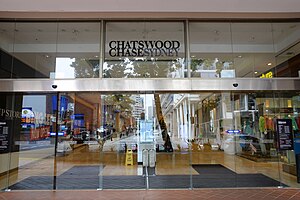
Chatswood Chase Sydney
Shopping mall in New South Wales, Australia
Distance: Approx. 558 meters
Latitude and longitude: -33.79418,151.186019
Chatswood Chase is a shopping centre in the suburb of Chatswood on the Lower North Shore of Sydney, Australia.

Westfield Chatswood
Shopping mall in New South Wales, Australia
Distance: Approx. 499 meters
Latitude and longitude: -33.796893,151.184111
Westfield Chatswood is a large indoor shopping centre in the suburb of Chatswood in the Lower North Shore of Sydney.

St Pius X College, Sydney
School in Chatswood, Lower North Shore, Sydney, New South Wales, Australia
Distance: Approx. 320 meters
Latitude and longitude: -33.79472222,151.18333333
St Pius X College (abbreviated as Pius) is an independent Catholic primary and secondary day school for boys, located in Chatswood, a lower North Shore suburb of Sydney, New South Wales, Australia. The school was established by the Congregation of Christian Brothers in 1937 and is operated under the auspices of Edmund Rice Education Australia. Oversight of the school is provided by the Catholic Education Office of the Diocese of Broken Bay.

Chatswood Public School
Government public school in Chatswood, New South Wales, Australia
Distance: Approx. 506 meters
Latitude and longitude: -33.79833333,151.17833333
Chatswood Public School is a primary and public school that was founded in 1883, located in the suburb of Chatswood in Sydney, New South Wales, Australia. This school provides a playground which has been changed throughout the years and four buildings.

Chislehurst, Chatswood
Former house and school in New South Wales, Australia
Distance: Approx. 716 meters
Latitude and longitude: -33.798728,151.17475
Chislehurst was a former house and former school building located in Chatswood West, Sydney, New South Wales, Australia. Completed in 1892 by the merchant and pastoralist John de Villiers Lamb, the former house was originally known as Maroomba.

Chatswood Interchange
Shopping mall in New South Wales, Australia
Distance: Approx. 395 meters
Latitude and longitude: -33.79714,151.181982
Chatswood Interchange (also known as The Interchange Chatswood or The Interchange) is a shopping centre in the suburb of Chatswood in the lower North Shore of Sydney and is integrated with the Chatswood railway station and features a Woolworths Metro supermarket, 70 speciality stores, three high-rise office towers and high-rise apartments.
Weather in this IP's area
overcast clouds
12 Celsius
12 Celsius
11 Celsius
13 Celsius
1022 hPa
87 %
1022 hPa
1008 hPa
10000 meters
4.12 m/s
300 degree
100 %
06:20:13
19:04:04